
Датотека:South East England districts 2011 map.svg

Veličina PNG pregleda za ovu SVG datoteku je 749 × 600 piksela. 6 drugih rezolucija: 300 × 240 piksela | 600 × 480 piksela | 959 × 768 piksela | 1.279 × 1.024 piksela | 2.558 × 2.048 piksela | 1.425 × 1.141 piksela.
Originalna datoteka (SVG datoteka, nominalno 1.425 × 1.141 piksela, veličina: 2,18 MB)
| Ovo je datoteka sa Vikimedijine ostave. Informacije sa njene stranice sa opisom prikazane su ispod. Vikimedijina ostava je skladište slobodno licenciralnih multimedijalnih datoteka. I Vi možete da pomognete. |
Opis izmene
| Opis |
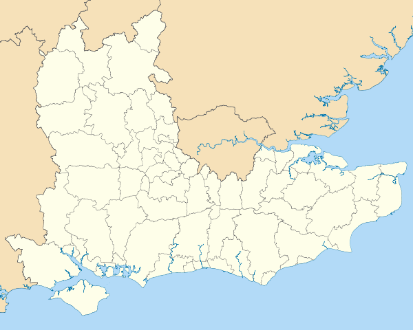
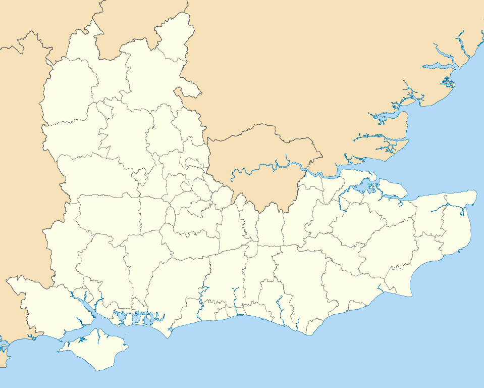
Map of the South East England region showing the administrative districts. Equirectangular map projection on WGS 84 datum, with N/S stretched 160% Geographic limits:
|
| Datum | |
| Izvor |
|
| Autor | Nilfanion, created using Ordnance Survey data |
| Ostale verzije |
Derivative works of this file: |
Licenciranje
Ja, nosilac autorskih prava nad ovim delom, objavljujem isto pod sledećim licencama:
Ova datoteka je dostupna pod licencom Creative Commons Autorstvo-Deliti pod istim uslovima 3.0 Unported.
- Dozvoljeno je:
- da delite – da umnožavate, raspodeljujete i prenosite delo
- da prerađujete – da preradite delo
- Pod sledećim uslovima:
- autorstvo – Morate da date odgovarajuće zasluge, obezbedite vezu ka licenci i naznačite da li su izmene napravljene. Možete to uraditi na bilo koji razuman manir, ali ne na način koji predlaže da licencator odobrava vas ili vaše korišćenje.
- deliti pod istim uslovima – Ako izmenite, preobrazite ili dogradite ovaj materijal, morate podeliti svoje doprinose pod istom ili kompatibilnom licencom kao original.

|
Data je dozvola da se kopira, distribuira i/ili menja ovaj dokument pod uslovima GNU-ove licence za slobodnu dokumentaciju, verzije 1.2 ili bilo koje novije verzije koju objavi Zadužbina za slobodni softver; bez nepromenljivih odeljaka i bez teksta na naslovnoj i zadnjoj strani. Tekst licence možete pročitati ovde. |
Izaberite licencu po želji.
Istorija datoteke
Kliknite na datum/vreme da biste videli tadašnju verziju datoteke.
| Datum/vreme | Minijatura | Dimenzije | Korisnik | Komentar | |
|---|---|---|---|---|---|
| trenutna | 21:04, 1. maj 2011. | | 1.425 × 1.141 (2,18 MB) | Nilfanion | == Summary == {{Information |Description=Map of the South East England region showing the administrative districts. Equirectangular map projection on WGS 84 datum, with N/S stretched 160% Geographic limits: *West: 2.0W *East: 1. |
Upotreba datoteke
Nema stranica koje koriste ovu datoteku.
Globalna upotreba datoteke
Drugi vikiji koji koriste ovu datoteku:
- Upotreba na ar.wikipedia.org
- Upotreba na bs.wikipedia.org
- Upotreba na ceb.wikipedia.org
- Upotreba na en.wikipedia.org
- Hastings
- Isle of Wight
- Oxford
- Portsmouth
- Reading, Berkshire
- South East England
- Oxfordshire
- East Sussex
- Brighton and Hove
- Bracknell Forest
- Borough of Runnymede
- Crawley
- Reigate and Banstead
- Mid Sussex District
- Medway
- Hart District
- West Berkshire
- Borough of Waverley
- Royal Borough of Windsor and Maidenhead
- Adur District
- Arun District
- Gosport
- Sevenoaks
- Borough of Dartford
- Basingstoke and Deane
- Worthing
- City of Milton Keynes
- Cherwell (district)
- Wealden District
- Vale of White Horse
- Tonbridge and Malling
- East Hampshire
- Rushmoor
- Test Valley
- Gravesham
- Borough of Swale
- Folkestone and Hythe District
- South Oxfordshire
- West Oxfordshire
- Borough of Spelthorne
- Surrey Heath
- Borough of Elmbridge
- Mole Valley
- Epsom and Ewell
- Tandridge District
- Rother District
- Lewes District
Još globalnog korišćenja ove datoteke.