
Датотека:South Williamson Kentucky aerial view.jpg

Veličina ovog prikaza: 800 × 534 piksela. 4 druge rezolucije: 320 × 214 piksela | 640 × 427 piksela | 1.024 × 683 piksela | 1.500 × 1.001 piksela.
Originalna datoteka (1.500 × 1.001 piksela, veličina datoteke: 814 kB, MIME tip: image/jpeg)
| Ovo je datoteka sa Vikimedijine ostave. Informacije sa njene stranice sa opisom prikazane su ispod. Vikimedijina ostava je skladište slobodno licenciralnih multimedijalnih datoteka. I Vi možete da pomognete. |
| Opis |
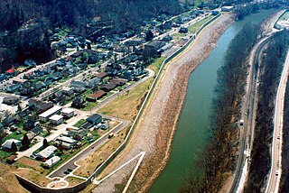
English: Aerial view of South Williamson, Kentucky, USA. The town is protected by a floodwall built along the Tug Fork River by the U.S. Army Corps of Engineers. The river here is the border between Kentucky and West Virginia. The view in this photograph is from the West Virginia side looking south-southwest over the river to South Williamson, Kentucky. |
|||
| Lokacija | South Williamson, Kentucky, USA 37°40′20.97″N 82°17′4.92″W / 37.6724917°N 82.2847°W |
|||
| Datum | ||||
| Izvor |
U.S. Army Corps of Engineers Digital Visual Library Image page Image description page Digital Visual Library home page |
|||
| Autor | U.S. Army Corps of Engineers, photographer not specified or unknown | |||
| Dozvola (Ponovno korišćenje ove datoteke) |
|
Istorija datoteke
Kliknite na datum/vreme da biste videli tadašnju verziju datoteke.
| Datum/vreme | Minijatura | Dimenzije | Korisnik | Komentar | |
|---|---|---|---|---|---|
| trenutna | 03:21, 22. mart 2007. | | 1.500 × 1.001 (814 kB) | DanMS | {{Information | Description = {{en|Aerial view of South Williamson, Kentucky, USA. The town is protected by a floodwall built along the Tug Fork River by the U.S. Army Corps of Engineers.}} | Source = U.S. Army Corps of Engineers Digital Visual |
Upotreba datoteke
Sledeća stranica koristi ovu datoteku:
Globalna upotreba datoteke
Drugi vikiji koji koriste ovu datoteku:
- Upotreba na azb.wikipedia.org
- Upotreba na ceb.wikipedia.org
- Upotreba na ce.wikipedia.org
- Upotreba na en.wikipedia.org
- Upotreba na es.wikipedia.org
- Upotreba na fa.wikipedia.org
- Upotreba na lld.wikipedia.org
- Upotreba na pl.wikipedia.org
- Upotreba na tt.wikipedia.org
- Upotreba na uk.wikipedia.org
- Upotreba na www.wikidata.org
- Upotreba na zh.wikipedia.org