
Датотека:St helens map showing 1980 eruption deposits.png
Veća rezolucija nije dostupna.
St_helens_map_showing_1980_eruption_deposits.png (702 × 527 piksela, veličina datoteke: 18 kB, MIME tip: image/png)
| Ovo je datoteka sa Vikimedijine ostave. Informacije sa njene stranice sa opisom prikazane su ispod. Vikimedijina ostava je skladište slobodno licenciralnih multimedijalnih datoteka. I Vi možete da pomognete. |
Opis izmene
| Opis | |
| Izvor | USGS |
| Autor | USGS |

|
Ова geology слика требало би да буду поново израђене као векторска графика у SVG формату. Тиме се остварује неколико предности. Више информација потражите на Commons:Media for cleanup. Ако је ова слика већ доступна у SVG формату, отпремите је. Након отпремања датотеке, овај шаблон замените шаблоном {{vector version available|new image name.svg}}.
|
Licenciranje
This image is in the public domain in the United States because it only contains materials that originally came from the United States Geological Survey, an agency of the United States Department of the Interior. For more information, see the official USGS copyright policy.
|
Prvobitan dnevnik otpremanja
The original description page was here. All following user names refer to en.wikipedia.
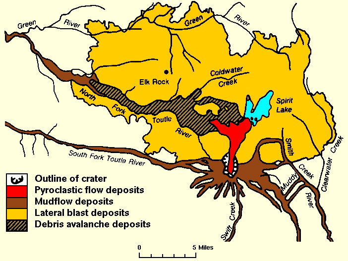
- 2007-12-27 01:18 Peteforsyth 702×527× (17938 bytes) replacing jpeg version, and cropping out extraneous text. Map of the area around Mount St. Helens which were affected by the May 18, 1980 eruption. North is to the top. [[USGS]] image from [http://vulcan.wr.usgs.gov/Volcanoes/MSH/SlideSet/ljt_slideset_
Istorija datoteke
Kliknite na datum/vreme da biste videli tadašnju verziju datoteke.
| Datum/vreme | Minijatura | Dimenzije | Korisnik | Komentar | |
|---|---|---|---|---|---|
| trenutna | 20:18, 24. maj 2011. | | 702 × 527 (18 kB) | File Upload Bot (Magnus Manske) | {{BotMoveToCommons|en.wikipedia|year={{subst:CURRENTYEAR}}|month={{subst:CURRENTMONTHNAME}}|day={{subst:CURRENTDAY}}}} {{Information |Description={{en|replacing jpeg version, and cropping out extraneous text. Map of the area around Mount St. Helens whic |
Upotreba datoteke
3 sledeće stranice koriste ovu datoteku:
Globalna upotreba datoteke
Drugi vikiji koji koriste ovu datoteku:
- Upotreba na bg.wikipedia.org
- Upotreba na cs.wikipedia.org
- Upotreba na el.wikipedia.org
- Upotreba na en.wikipedia.org
- Upotreba na fa.wikipedia.org
- Upotreba na id.wikipedia.org
- Upotreba na km.wikipedia.org
- Upotreba na mk.wikipedia.org
- Upotreba na ms.wikipedia.org
- Upotreba na ne.wikipedia.org
- Upotreba na nl.wikipedia.org
- Upotreba na pt.wikipedia.org
- Upotreba na simple.wikipedia.org
- Upotreba na te.wikipedia.org
- Upotreba na th.wikipedia.org
- Upotreba na tr.wikipedia.org
- Upotreba na uk.wikipedia.org
- Upotreba na uz.wikipedia.org
- Upotreba na vi.wikipedia.org
- Upotreba na zh.wikipedia.org