
Датотека:The Road to the Stars.jpg

Veličina ovog prikaza: 800 × 527 piksela. 6 drugih rezolucija: 320 × 211 piksela | 640 × 421 piksela | 1.024 × 674 piksela | 1.280 × 843 piksela | 2.560 × 1.686 piksela | 5.148 × 3.390 piksela.
Originalna datoteka (5.148 × 3.390 piksela, veličina datoteke: 4,07 MB, MIME tip: image/jpeg)
| Ovo je datoteka sa Vikimedijine ostave. Informacije sa njene stranice sa opisom prikazane su ispod. Vikimedijina ostava je skladište slobodno licenciralnih multimedijalnih datoteka. I Vi možete da pomognete. |
Opis izmene
| Opis |
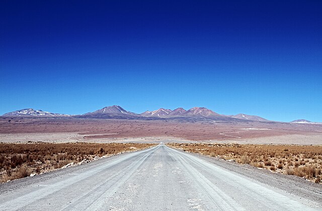
English: This photograph shows the road to the Atacama Large Millimeter/submillimeter Array (ALMA)’s Operations Support Facility (OSF) and then on further to the breathtaking Chajnantor Plateau at 5000 metres above sea level. The plateau, situated in Chilean Puna in the Atacama region, is home to the Array Operations Site (AOS) and is the site of the highest and driest astronomical observatory on Earth.
The OSF is the centre of activities for the ALMA project and is where all staff and contractors are accommodated — only 2900 metres above sea level. This is where all the scientific operations related to the daily operation of the observatory take place. The AOS houses a technical building — the second highest building on Earth — along with the ALMA correlator, the highest and fastest computer ever used at an astronomical site. Due to the high altitude, human operations are kept to a minimum. ALMA will address some of the deepest questions of our cosmic origins as it explores the cool Universe – in particular molecular clouds, star formation and planetary systems. |
||||
| Datum | |||||
| Izvor | http://www.eso.org/public/images/potw1530a/ | ||||
| Autor | NAOJ/ALMA (ESO/NAOJ/NRAO) | ||||
| Dozvola (Ponovno korišćenje ove datoteke) |
|
||||
| Положај камере | | Ова и друге слике снимљене у близини на: OpenStreetMap |
|---|
| Annotations | This image is annotated: View the annotations at Commons |
.jpg)
Istorija datoteke
Kliknite na datum/vreme da biste videli tadašnju verziju datoteke.
| Datum/vreme | Minijatura | Dimenzije | Korisnik | Komentar | |
|---|---|---|---|---|---|
| trenutna | 17:47, 14. februar 2024. | | 5.148 × 3.390 (4,07 MB) | C messier | full size |
| 10:44, 27. jul 2015. |  | 1.280 × 843 (203 kB) | Jmencisom | User created page with UploadWizard |
Upotreba datoteke
Sledeća stranica koristi ovu datoteku:
Globalna upotreba datoteke
Drugi vikiji koji koriste ovu datoteku:
- Upotreba na en.wikipedia.org
- Upotreba na sl.wikipedia.org
- Upotreba na ur.wikipedia.org