
Датотека:WRF rita spread2.jpg
Veća rezolucija nije dostupna.
WRF_rita_spread2.jpg (311 × 504 piksela, veličina datoteke: 51 kB, MIME tip: image/jpeg)
| Ovo je datoteka sa Vikimedijine ostave. Informacije sa njene stranice sa opisom prikazane su ispod. Vikimedijina ostava je skladište slobodno licenciralnih multimedijalnih datoteka. I Vi možete da pomognete. |
Opis izmene
| Opis |
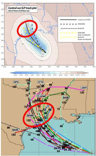
English: (Top): WRF model simulation of Hurricane Rita tracks. The model resolution is 30km. The colored field shows the lowest sea-level pressure (SLP) recorded during the last 27 hours of a 54 hour control simulation of Rita using LFO (5 class) microphysics and the Kain-Fritsch (KF) convective scheme. The superposed black line traces the model hurricane, which strikes Houston. Also shown are tracks of minimum SLP for runs using the Kessler (warm rain) scheme, the WSM3 simple ice scheme (with the Betts-Miller-Jancic convective scheme), the Kessler with reduced rain fallspeed, and WSM3 with enhanced ice fallspeed. (Bottom): The spread of NHC multi-model ensemble forecast at 06 UTC, 22 September. Note a similar ensemble spread was obtained from a single model simply by varying the model microphysics and convective schemes. Image from Jonathan Vigh, Colorado State University. |
| Izvor | http://mls.jpl.nasa.gov/research/hurricanes.php |
| Autor | Prof. Robert Fovell (UCLA); Dr. Hui Su (JPL) |
http://www.jpl.nasa.gov/imagepolicy/
Licenciranje
| Ова датотека је у јавном власништву зато што је њен аутор НАСА. НАСА-а политика ауторских права наводи „Материјали НАСА-е нису заштићени ауторским правима осим ако није другачије наведено“. (Погледајте Template:PD-USGov, NASA copyright policy page или JPL Image Use Policy.) | ||
 |
Упозорења:
|
Istorija datoteke
Kliknite na datum/vreme da biste videli tadašnju verziju datoteke.
| Datum/vreme | Minijatura | Dimenzije | Korisnik | Komentar | |
|---|---|---|---|---|---|
| trenutna | 23:49, 5. mart 2010. | | 311 × 504 (51 kB) | Atmoz | {{Information |Description={{en|1=(Top): WRF model simulation of Hurricane Rita tracks. The model resolution is 30km. The colored field shows the lowest sea-level pressure (SLP) recorded during the last 27 hours of a 54 hour control simulation of Rita usi |
Upotreba datoteke
Sledeća stranica koristi ovu datoteku:
Globalna upotreba datoteke
Drugi vikiji koji koriste ovu datoteku:
- Upotreba na el.wikipedia.org
- Upotreba na en.wikipedia.org
- Upotreba na fa.wikipedia.org
- Upotreba na fr.wikipedia.org