
Датотека:Yasi feb 1 2011 0000Z.jpg

Originalna datoteka (7.200 × 9.400 piksela, veličina datoteke: 7,93 MB, MIME tip: image/jpeg)
| Ovo je datoteka sa Vikimedijine ostave. Informacije sa njene stranice sa opisom prikazane su ispod. Vikimedijina ostava je skladište slobodno licenciralnih multimedijalnih datoteka. I Vi možete da pomognete. |
| Warning | The original file is very high-resolution. It might not load properly or could cause your browser to freeze when opened at full size. |
|---|
Opis izmene
| Opis |
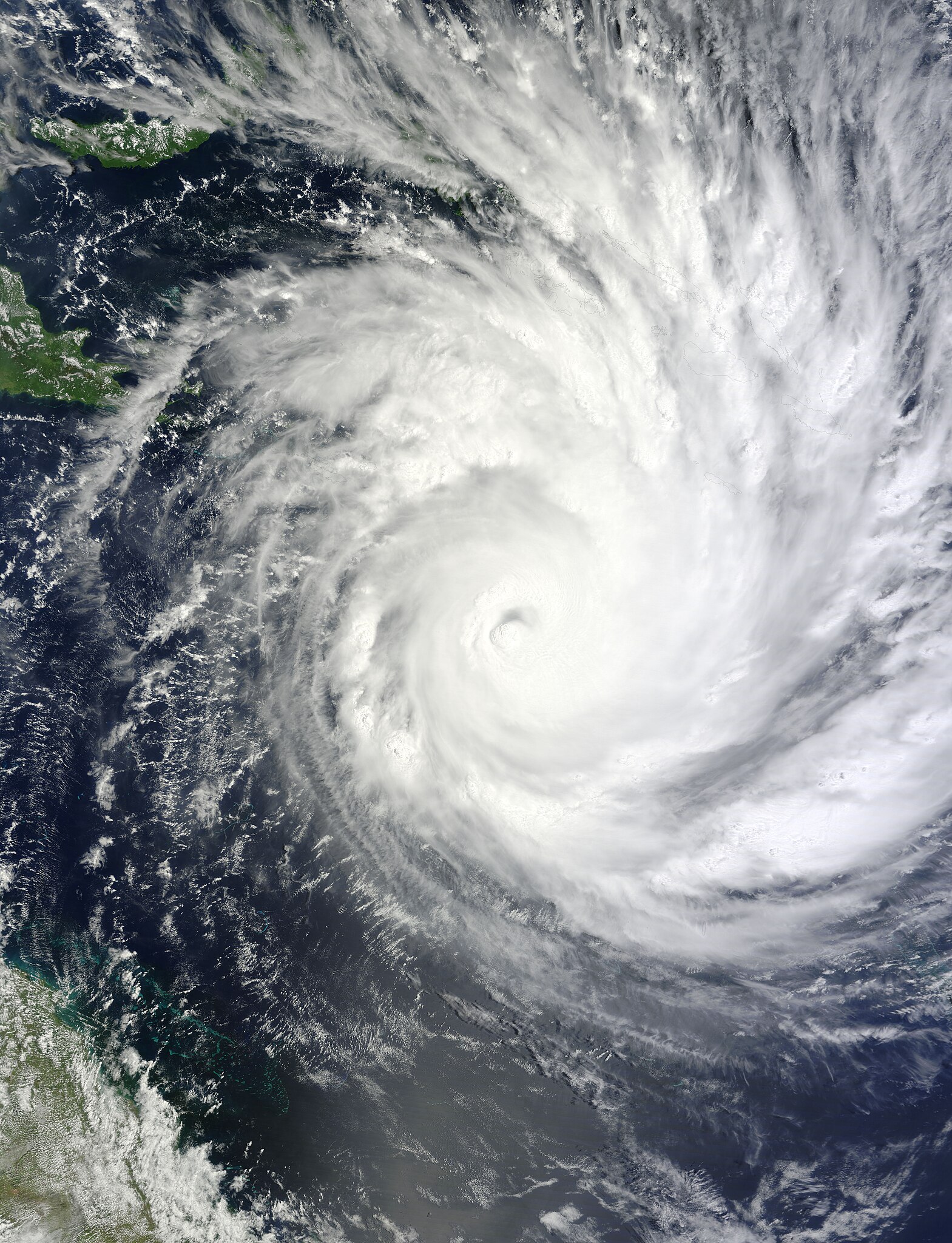
English: On February 1, 2011, Tropical Cyclone Yasi continued on its path toward Queensland, Australia. The Moderate Resolution Imaging Spectroradiometer (MODIS) on NASA’s Terra satellite captured this natural-color image at 10:00 a.m. Queensland time (00:00 UTC) on February 1. The storm extends over the Solomon Islands (outlined in black) and grazes Papua New Guinea. Part of the Queensland coast appears in the lower left corner of the image.
At 1:00 a.m. on February 2 Queensland time (15:00 on February 1 UTC), the U.S. Navy’s Joint Typhoon Warning Center (JTWC) reported that Yasi was roughly 450 nautical miles (835 kilometers) east-northeast of Cairns, Queensland, Australia. Sporting a well-defined eye, Yasi had maximum sustained winds of 120 knots (220 kilometers per hour) and gusts up to 145 knots (270 kilometers per hour). True to earlier forecasts, favorable conditions had enabled the storm to intensify rapidly over the Pacific Ocean. The JTWC forecast that Yasi would continue to strengthen and would remain on west-southwestward track. The storm was expected to make landfall just south of Cairns, bringing high winds and potentially high waves. The Sydney Morning Herald reported that tens of thousands of residents were evacuating ahead of the storm’s anticipated landfall late February 2 or early February 3. |
| Datum | |
| Izvor | http://rapidfire.sci.gsfc.nasa.gov/gallery/?2011032-0201/Yasi.A2011032.0000.2km.jpg |
| Autor | NASA image by Jeff Schmaltz, MODIS Rapid Response Team at NASA GSFC. Caption by Michon Scott |
Licenciranje
| Ова датотека је у јавном власништву зато што је њен аутор НАСА. НАСА-а политика ауторских права наводи „Материјали НАСА-е нису заштићени ауторским правима осим ако није другачије наведено“. (Погледајте Template:PD-USGov, NASA copyright policy page или JPL Image Use Policy.) | ||
 |
Упозорења:
|
Istorija datoteke
Kliknite na datum/vreme da biste videli tadašnju verziju datoteke.
| Datum/vreme | Minijatura | Dimenzije | Korisnik | Komentar | |
|---|---|---|---|---|---|
| trenutna | 15:52, 13. avgust 2023. | | 7.200 × 9.400 (7,93 MB) | Nino Marakot | Original color |
| 13:07, 1. februar 2011. |  | 7.200 × 9.400 (10,9 MB) | Supportstorm | {{Information |Description ={{en|1=Severe Tropical Cyclone Yasi, as a category three, on February 1, 2011.}} |Source =http://rapidfire.sci.gsfc.nasa.gov/gallery/?2011032-0201/Yasi.A2011032.0000.2km.jpg |Author =NASA/ GSFC, MODIS Rapid R |
Upotreba datoteke
Nema stranica koje koriste ovu datoteku.
Globalna upotreba datoteke
Drugi vikiji koji koriste ovu datoteku:
- Upotreba na en.wikipedia.org
- Upotreba na pt.wikipedia.org
- Upotreba na zh.wikipedia.org