
Датотека:1822 Geographical, Statistical, and Historical Map of Florida by Henry Charles Carey, Isaac Lea and Fielding Lucas.png

Величина овог приказа: 498 × 599 пиксела. 3 друге резолуције: 199 × 240 пиксела | 399 × 480 пиксела | 804 × 967 пиксела.
Оригинална датотека (804 × 967 пиксела, величина датотеке: 1,39 MB, MIME тип: image/png)
| Ово је датотека са Викимедијине оставе. Информације са њене странице са описом приказане су испод. Викимедијина остава је складиште слободно лиценциралних мултимедијалних датотека. И Ви можете да помогнете. |
Опис измене
| Опис |
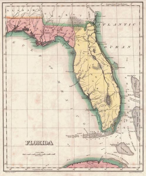
English: 1822 map of Florida Territory, published less then a year after Florida was ceded to the U.S. by Spain. The map delineates the territory's two original counties – Escambia and St. Johns, whose initial boundaries were conterminous with those of the earlier districts of East and West Florida. The interior river system is still largely anecdote and conjecture. Two roads lead west out of St. Augustine, one to Rollstown on the St. Johns River and the other to Ivitachua. A number of early northern forts are listed, including Ft. Barancas, Ft. Gadsden or Collinton, Ft. St. Marks, Ft. Poppa, Picolota Ft., and a British Fort erected during the war on the Apalachicola River. |
| Датум | |
| Извор |
Original publication: A Complete Historical, Chronological, And Geographical American Atlas, Being A Guide To The History Of North And South America, And The West Indies ... To The Year 1822. According To The Plan Of Le Sage's Atlas And Intended As A Companion To Lavoisne's Improvement Of That Celebrated Work." (Philadelphia, PA: Carey and Lea, 1822) |
| Аутор |
Henry Charles Carey, Isaac Lea, Fielding Lucas |
- Other information
English: This is an image of an original map that is in the public domain. This image is not a derivative work of the original map, as it has not been improved through techniques such as cutting out backgrounds, fixing broken lines, simplification, sharpening or otherwise cleaning up.
Лиценцирање
Овај рад је у јавном власништву у Сједињеним Државама зато што је објављен или регистрован у канцеларији за ауторска права САД-а пре 1. јануара 1929.
Овај рад мора бити у јавном власништву у Сједињеним Државама и држави порекла да би се хостовао на Остави. Ако рад није дело америчког аутора, датотека обавезно мора имати и ознаку ауторских права за државу порекла да би се знало зашто је овај рад у јавном власништву у држави порекла.
|
Историја датотеке
Кликните на датум/време да бисте видели тадашњу верзију датотеке.
| Датум/време | Минијатура | Димензије | Корисник | Коментар | |
|---|---|---|---|---|---|
| тренутна | 15:16, 30. јануар 2016. | | 804 × 967 (1,39 MB) | Jeff in CA | re-cropped image |
| 12:40, 30. јануар 2016. |  | 830 × 984 (1,82 MB) | Jeff in CA | {{subst:Upload marker added by en.wp UW}} {{Information |Description = {{en|One of the earliest obtainable separate maps of Florida following its admission as a Territory in July 1821, the map pre-dates all but St. John's County, with the only delineat... |
Употреба датотеке
2 следеће странице користе ову датотеку:
Глобална употреба датотеке
Други викији који користе ову датотеку:
- Употреба на ar.wikipedia.org
- Употреба на bn.wikipedia.org
- Употреба на br.wikipedia.org
- Употреба на en.wikipedia.org
- Употреба на es.wikipedia.org
- Употреба на et.wikipedia.org
- Употреба на gl.wikipedia.org
- Употреба на he.wikipedia.org
- Употреба на pt.wikipedia.org
- Употреба на tr.wikipedia.org
- Употреба на vi.wikipedia.org