
Датотека:1973 sinai war maps.jpg

Оригинална датотека (1.165 × 894 пиксела, величина датотеке: 217 kB, MIME тип: image/jpeg)
| Ово је датотека са Викимедијине оставе. Информације са њене странице са описом приказане су испод. Викимедијина остава је складиште слободно лиценциралних мултимедијалних датотека. И Ви можете да помогнете. |
Опис измене
| Опис |
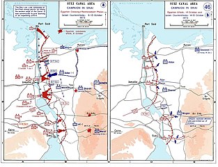
العربية: خريطة للتحركات العسكرية على الجبهة المصرية في حرب أكتوبر في الفترة بين 6 و 13 أكتوبر.
English: Sinai maps, from the US Military Academy History archives (copyright US government?)
Background information: In 1938 the predecessors of what is today The Department of History at the United States Military Academy began developing a series of campaign atlases to aid in teaching cadets a course entitled, "History of the Military Art." Since then, the Department has produced over six atlases and more than one thousand maps, encompassing not only America’s wars but global conflicts as well. In keeping abreast with today's technology, the Department of History is providing these maps on the internet as part of the department's outreach program. The maps were created by the United States Military Academy’s Department of History and are the digital versions from the atlases printed by the United States Defense Printing Agency. We gratefully acknowledge the accomplishments of the department's former cartographer, Mr. Edward J. Krasnoborski, along with the works of our present cartographer, Mr. Frank Martini. Please be aware that these maps are large in file size and may require substantial download times.. |
| Датум | 2005-04-220 |
| Извор |
|
| Аутор | Ondrejk |
| Остале верзије |
 |
Ова датотека је рад припадника Америчке војске или особе запослене у њој и начињена је за време обављања дужности те особе. Као рад америчке савезне владе, ова датотека је у јавном власништву у САД-у.
|
 |
Downloaded and copied from EN-wiki
Историја датотеке
Кликните на датум/време да бисте видели тадашњу верзију датотеке.
| Датум/време | Минијатура | Димензије | Корисник | Коментар | |
|---|---|---|---|---|---|
| тренутна | 23:06, 1. јун 2009. | | 1.165 × 894 (217 kB) | Hohum | Cleaned up |
| 20:09, 20. април 2005. |  | 1.165 × 894 (174 kB) | Thuresson | larger size | |
| 19:56, 20. април 2005. |  | 1.000 × 765 (63 kB) | Ondrejk | Sinai maps, from the US Military Academy History archives (copyright US government?) Source: Department of History, U.S. Military Academy {{PD-USGov}} Downloaded and copied from EN-wiki |
Употреба датотеке
Следећа страница користи ову датотеку:
Глобална употреба датотеке
Други викији који користе ову датотеку:
- Употреба на af.wikipedia.org
- Употреба на ast.wikipedia.org
- Употреба на bg.wikipedia.org
- Употреба на ca.wikipedia.org
- Употреба на cy.wikipedia.org
- Употреба на da.wikipedia.org
- Употреба на de.wikipedia.org
- Употреба на el.wikipedia.org
- Употреба на en.wikipedia.org
- Употреба на eo.wikipedia.org
- Употреба на es.wikipedia.org
- Употреба на eu.wikipedia.org
- Употреба на fi.wikipedia.org
- Употреба на fr.wikipedia.org
- Употреба на gl.wikipedia.org
- Употреба на he.wikipedia.org
- Употреба на id.wikipedia.org
- Употреба на it.wikipedia.org
- Употреба на it.wikibooks.org
- Употреба на ja.wikipedia.org
- Употреба на jv.wikipedia.org
- Употреба на lv.wikipedia.org
- Употреба на ms.wikipedia.org
- Употреба на ne.wikipedia.org
- Употреба на nl.wikipedia.org
- Употреба на nn.wikipedia.org
- Употреба на no.wikipedia.org
Још глобалног коришћења ове датотеке.