
Датотека:Bonadelle Ranchos-Madera Ranchos, California (20952163403).jpg

Оригинална датотека (4.000 × 3.000 пиксела, величина датотеке: 2,62 MB, MIME тип: image/jpeg)
| Ово је датотека са Викимедијине оставе. Информације са њене странице са описом приказане су испод. Викимедијина остава је складиште слободно лиценциралних мултимедијалних датотека. И Ви можете да помогнете. |
.jpg)
Опис измене
| Опис |
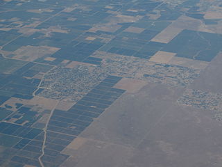
Bonadelle Ranchos-Madera Ranchos is a census-designated place (CDP) in Madera County, California, United States. It is part of the Madera–Chowchilla Metropolitan Statistical Area. The population was 8,569 at the 2010 census, up from 7,300 at the 2000 census. The Bonadelle Ranchos is often regarded as a Valley-Foothill transitional zone, because its elevation is higher than average for valley but slightly too low to be considered part of the Sierra foothills. Immediately Northeast lies the rugged foothills of the Sierra Nevada range. Its environment corresponds, showing qualities of a transition zone. The Northeast portion of the area is the highest in elevation,and small tabletop hills are present: most notably Adobe Hill, which lies at an elevation of 640 feet. All throughout the area, there is large, rolling hills. Multiple creeks run through the area, but none are large enough to bring constant flow. The creeks include Little Dry Creek, Bonadelle Creek, Cottonwood Creek, and Root Creek. Many of these waterways flow in the winter months, when rainfall and snow filter down from the nearby foothills. There are many seasonal ponds in the area, however most are too small and short-lived to offer recreational activities. Many of the wildlife is typical for this type of environment. Mammals include foxes, ground squirrels, coyotes, raccoons, skunks and occasionally bobcats and mountain lions. Dove, crows, ravens, ducks, Scrub jays, California woodpeckers, egrets, red tailed hawks, turkey vultures, and geese can be found as well. en.wikipedia.org/wiki/Bonadelle_Ranchos-Madera_Ranchos,_C... en.wikipedia.org/wiki/Wikipedia:Text_of_Creative_Commons_... |
| Датум | |
| Извор | Bonadelle Ranchos-Madera Ranchos, California |
| Аутор | Ken Lund from Reno, Nevada, USA |
| Положај камере | | Ова и друге слике снимљене у близини на: OpenStreetMap |
|---|
.jpg¶ms=037.041013_N_-119.595634_E_globe:Earth_type:camera_source:Flickr_&language=sr)
Лиценцирање
- Дозвољено је:
- да делите – да умножавате, расподељујете и преносите дело
- да прерађујете – да прерадите дело
- Под следећим условима:
- ауторство – Морате да дате одговарајуће заслуге, обезбедите везу ка лиценци и назначите да ли су измене направљене. Можете то урадити на било који разуман манир, али не на начин који предлаже да лиценцатор одобрава вас или ваше коришћење.
- делити под истим условима – Ако измените, преобразите или доградите овај материјал, морате поделити своје доприносе под истом или компатибилном лиценцом као оригинал.
| This image was originally posted to Flickr by Ken Lund at https://flickr.com/photos/75683070@N00/20952163403. It was reviewed on 4. децембар 2015. by FlickreviewR and was confirmed to be licensed under the terms of the cc-by-sa-2.0. |
Историја датотеке
Кликните на датум/време да бисте видели тадашњу верзију датотеке.
| Датум/време | Минијатура | Димензије | Корисник | Коментар | |
|---|---|---|---|---|---|
| тренутна | 06:50, 4. децембар 2015. | | 4.000 × 3.000 (2,62 MB) | INeverCry | Transferred from Flickr via Flickr2Commons |
Употреба датотеке
Следећа страница користи ову датотеку:
Глобална употреба датотеке
Други викији који користе ову датотеку:
- Употреба на en.wikipedia.org
- Употреба на nv.wikipedia.org
- Употреба на pl.wikipedia.org
- Употреба на simple.wikipedia.org
- Употреба на uk.wikipedia.org
.jpg)