
Датотека:World PVOUT Solar-resource-map GlobalSolarAtlas World-Bank-Esmap-Solargis.png

Оригинална датотека (1.889 × 1.122 пиксела, величина датотеке: 1,37 MB, MIME тип: image/png)
| Ово је датотека са Викимедијине оставе. Информације са њене странице са описом приказане су испод. Викимедијина остава је складиште слободно лиценциралних мултимедијалних датотека. И Ви можете да помогнете. |
Опис измене
| Опис |
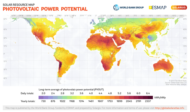
English: This solar resource map provides a summary of the estimated solar energy available for power generation and other energy applications. It represents the average daily/yearly sum of electricity production from a 1 kW-peak grid-connected solar PV power plant covering the period from 1994/1999/2007 (depending on the geographical region) to 2015. The underlying solar resource database is calculated by the Solargis model from atmospheric and satellite data with 15-minute and 30-minute time step respectively, and a spatial resolution of 1 km. Further details available from: https://globalsolaratlas.info. |
||
| Датум | |||
| Извор | https://globalsolaratlas.info | ||
| Аутор | Solargis | ||
| Дозвола (Поновно коришћење ове датотеке) |
https://globalsolaratlas.info/support/terms-of-use
|
||
| Ауторство (required by the license) | © The World Bank / | ||

The World Bank and the International Finance Corporation (IFC), collectively the World Bank Group, have published this solar resource map alongside a Global Solar Atlas consisting of global, regional and country maps, to support the scale-up of solar power in our client countries. This work is funded by the Energy Sector Management Assistance Program (ESMAP), a multi-donor trust fund administered by The World Bank and supported by 13 official bilateral donors. It is part of a global ESMAP initiative on Renewable Energy Resource Mapping that covers biomass, small hydro, solar and wind. The World Bank Group has selected Solargis as its global provider of solar resource data and related services, and this map has been prepared by Solargis, under contract to The World Bank, based on a solar resource database that they own and maintain. To obtain additional maps and information, please visit: http://globalsolaratlas.info.
Лиценцирање
- Дозвољено је:
- да делите – да умножавате, расподељујете и преносите дело
- да прерађујете – да прерадите дело
- Под следећим условима:
- ауторство – Морате да дате одговарајуће заслуге, обезбедите везу ка лиценци и назначите да ли су измене направљене. Можете то урадити на било који разуман манир, али не на начин који предлаже да лиценцатор одобрава вас или ваше коришћење.
Историја датотеке
Кликните на датум/време да бисте видели тадашњу верзију датотеке.
| Датум/време | Минијатура | Димензије | Корисник | Коментар | |
|---|---|---|---|---|---|
| тренутна | 12:58, 15. јул 2020. | | 1.889 × 1.122 (1,37 MB) | Juraj.betak | Upgraded data on the map (climate period now to 2018, before to 2015; PVOUT data calculated with updated Solargis model) |
| 15:36, 25. септембар 2018. |  | 1.889 × 1.122 (1,68 MB) | O-Jay | User created page with UploadWizard |
Употреба датотеке
Следећа страница користи ову датотеку:
Глобална употреба датотеке
Други викији који користе ову датотеку:
- Употреба на ca.wikipedia.org
- Употреба на cs.wikipedia.org
- Употреба на de.wikipedia.org
- Употреба на en.wikipedia.org
- Употреба на es.wikipedia.org
- Употреба на fa.wikipedia.org
- Употреба на ru.wikipedia.org
- Употреба на uk.wikipedia.org
- Употреба на ur.wikipedia.org