
Датотека:Greater Croatia 01.png
Величина овог приказа: 663 × 600 пиксела. 4 друге резолуције: 265 × 240 пиксела | 531 × 480 пиксела | 849 × 768 пиксела | 1.151 × 1.041 пиксела.
Оригинална датотека (1.151 × 1.041 пиксела, величина датотеке: 153 kB, MIME тип: image/png)
| Ово је датотека са Викимедијине оставе. Информације са њене странице са описом приказане су испод. Викимедијина остава је складиште слободно лиценциралних мултимедијалних датотека. И Ви можете да помогнете. |
Опис измене
| Опис |
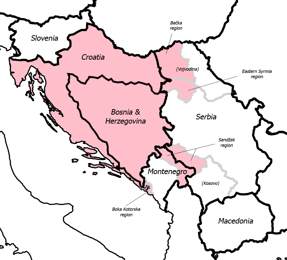
English: Fixed some detail, used overlaid Sandzak, Backa & Syrmium regions so it's much more accurate now. Pink coloring denotes regions claimed by Greater Croatian proponents. Current country borders are black, regional borders (only those that are relevant to the article) are grey.
CommentMap is still wrong:) Croatian-Slovenian border in Istria is 20 kilometars southern that it should be (Umag and Savudrija are in Croatia, hej!) And borders of eastern Srijem are not correct (Zemun and Novi Beograd are part of Srijem, too).
|
| Датум | 24. мај 2006. (првобитни датум слања) |
| Извор | Пребачено са en.wikipedia на Оставу. |
| Аутор | Dr.Gonzo на енглески Википедија |
| Остале верзије |
|


Лиценцирање
| Ово дело је њен носилац ауторских права Dr.Gonzo на енглески Википедија предао у јавно власништво. Ово се односи на цео свет. У неким земљама, ово није законски могуће; у том случају: Dr.Gonzo творац овог дела дозвољава свакоме да користи ово дело за било коју намену, без било каквих услова, осим услова које намеће закон. |
Првобитан дневник отпремања
Оригиналан опис странице је био овде. Сва наведена корисничка имена воде на en.wikipedia.
- 2007-03-13 10:42 Dr.Gonzo 1151×1041×8 (156832 bytes) Fixed the Istria border (sorry for that, the blank map I used already had that mistake)
- 2006-05-24 22:25 Dr.Gonzo 1151×1041×8 (154088 bytes) Fixed some detail, used overlayed Sandzak, Backa & Syrmium regions so it's much more accurate now.
- 2006-05-24 19:10 Dr.Gonzo 1151×1041×8 (153078 bytes) First version, self made. Some minor geographical detail may be incorrect. Pink coloring denotes regions claimed by Greater Croatian proponents.
Историја датотеке
Кликните на датум/време да бисте видели тадашњу верзију датотеке.
| Датум/време | Минијатура | Димензије | Корисник | Коментар | |
|---|---|---|---|---|---|
| тренутна | 00:40, 26. фебруар 2008. | | 1.151 × 1.041 (153 kB) | File Upload Bot (Magnus Manske) | {{BotMoveToCommons|en.wikipedia}} {{Information |Description={{en|Fixed some detail, used overlaid Sandzak, Backa & Syrmium regions so it's much more accurate now. Pink coloring denotes regions claimed by Greater Croatian proponents. Current country bord |
Употреба датотеке
Следећа страница користи ову датотеку:
Глобална употреба датотеке
Други викији који користе ову датотеку:
- Употреба на ar.wikipedia.org
- Употреба на bs.wikipedia.org
- Употреба на cs.wikipedia.org
- Употреба на de.wikipedia.org
- Употреба на el.wikipedia.org
- Употреба на en.wikipedia.org
- Употреба на id.wikipedia.org
- Употреба на ja.wikipedia.org
- Употреба на pt.wikipedia.org
- Употреба на sh.wikipedia.org
- Употреба на uk.wikipedia.org
- Употреба на www.wikidata.org