
Датотека:Huygens shoreline.jpg

Већа резолуција није доступна.
Huygens_shoreline.jpg (305 × 261 пиксела, величина датотеке: 24 kB, MIME тип: image/jpeg)
| Ово је датотека са Викимедијине оставе. Информације са њене странице са описом приказане су испод. Викимедијина остава је складиште слободно лиценциралних мултимедијалних датотека. И Ви можете да помогнете. |
Опис измене
| Опис |
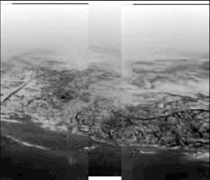
English: This composite was produced from images returned yesterday, January 14, 2005, by the European Space Agency's Huygens probe during its successful descent to land on Titan. It shows the boundary between the lighter-colored uplifted terrain, marked with what appear to be drainage channels, and darker lower areas. These images were taken from an altitude of about 8 kilometers (about 5 miles) and a resolution of about 20 meters (about 65 feet) per pixel. The images were taken by the Descent Imager/Spectral Radiometer, one of two NASA instruments on the probe.
Deutsch: Fotografie der Titanoberfläche während des Landeanflugs von Huygens. Man erkennt Hügel und topographische Merkmale, die einer Küstenregion mit Abflussgräben gleichen, 2005. |
| Датум | |
| Извор | http://photojournal.jpl.nasa.gov/catalog/PIA07231 (image link) |
| Аутор | NASA/JPL/ESA/University of Arizona |
This image or video was catalogued by Jet Propulsion Laboratory of the United States National Aeronautics and Space Administration (NASA) under Photo ID: PIA07231. This tag does not indicate the copyright status of the attached work. A normal copyright tag is still required. See Commons:Licensing. Other languages:
|
Лиценцирање
| Ова датотека је у јавном власништву зато што је њен аутор НАСА. НАСА-а политика ауторских права наводи „Материјали НАСА-е нису заштићени ауторским правима осим ако није другачије наведено“. (Погледајте Template:PD-USGov, NASA copyright policy page или JPL Image Use Policy.) | ||
 |
Упозорења:
|
Првобитан дневник отпремања
(All user names refer to en.wikipedia)
- 2005-01-15 18:17 The Singing Badger 305×261×8 (25004 bytes) Descent image of Titan taken during Huygens' landing, showing an apparent shoreline with hills and drainage channels {{PD-USGov-NASA}}
Историја датотеке
Кликните на датум/време да бисте видели тадашњу верзију датотеке.
| Датум/време | Минијатура | Димензије | Корисник | Коментар | |
|---|---|---|---|---|---|
| тренутна | 19:31, 14. новембар 2007. | | 305 × 261 (24 kB) | File Upload Bot (Magnus Manske) | {{BotMoveToCommons|en.wikipedia}} {{Information |Description={{en|Image of Titan taken during Huygens' descent, showing hills and topographical features that resemble a shoreline and drainage channels Credit: [ |
Употреба датотеке
Следећа страница користи ову датотеку:
Глобална употреба датотеке
Други викији који користе ову датотеку:
- Употреба на als.wikipedia.org
- Употреба на ar.wikipedia.org
- Употреба на de.wikipedia.org
- Употреба на en.wikipedia.org
- Употреба на fr.wikipedia.org
- Употреба на gl.wikipedia.org
- Употреба на id.wikipedia.org
- Употреба на io.wikipedia.org
- Употреба на it.wikipedia.org
- Употреба на ja.wikipedia.org
- Употреба на lb.wikipedia.org
- Употреба на nl.wikipedia.org
- Употреба на no.wikipedia.org
- Употреба на ru.wikipedia.org
- Употреба на simple.wikipedia.org
- Употреба на sv.wikipedia.org
- Употреба на zh.wikipedia.org