
Датотека:Judge Nathan Roberts House, State Highway 5, Canastota vicinity (Madison County, New York).jpg
Већа резолуција није доступна.
Judge_Nathan_Roberts_House,_State_Highway_5,_Canastota_vicinity_(Madison_County,_New_York).jpg (553 × 323 пиксела, величина датотеке: 97 kB, MIME тип: image/jpeg)
| Ово је датотека са Викимедијине оставе. Информације са њене странице са описом приказане су испод. Викимедијина остава је складиште слободно лиценциралних мултимедијалних датотека. И Ви можете да помогнете. |
|
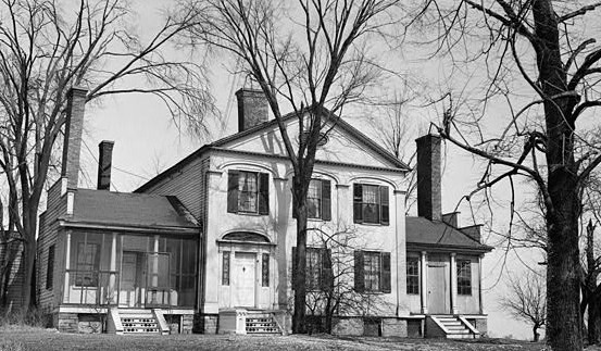
This is an image of a place or building that is listed on the National Register of Historic Places in the United States of America. Its reference number is 86001305. |
| Опис |
English: Judge Nathan Roberts House, State Highway 5, Canastota vicinity (Madison County, New York)
cropped |
|||||
| Датум | ||||||
| Извор | http://memory.loc.gov/cgi-bin/displayPhoto.pl?path=/pnp/habshaer/ny/ny0200/ny0262/photos&topImages=117115pr.jpg&topLinks=117115pv.jpg,117115pu.tif&title=1.%20%20Historic%20American%20Buildings%20Survey,%20M.E.%20Granger,%20Photographer%20Mar.%2028,%201934,%20VIEW%20FROM%20SOUTH%20(FRONT).%3cbr%3eHABS%20NY,27-CANA.V,1-1&displayProfile=0 | |||||
| Аутор | M.E. Granger, Photographer | |||||
| Дозвола (Поновно коришћење ове датотеке) |
|

.jpg)
.%3cbr%3eHABS%20NY,27-CANA.V,1-1&displayProfile=0)
| Положај објекта | | Ова и друге слике снимљене у близини на: OpenStreetMap |
|---|
.jpg¶ms=043.068333_N_-075.758889_E_globe:Earth_class:object_region:US_type:landmark_scale:1500_&language=sr)
Историја датотеке
Кликните на датум/време да бисте видели тадашњу верзију датотеке.
| Датум/време | Минијатура | Димензије | Корисник | Коментар | |
|---|---|---|---|---|---|
| тренутна | 19:25, 2. август 2009. | | 553 × 323 (97 kB) | KudzuVine | {{Information |Description={{en|1=Judge Nathan Roberts House, State Highway 5, Canastota vicinity (Madison County, New York) cropped {{PD-USGov-Interior-HABS|NY,27-CANA.V,1-1}}}} |Source=http://memory.loc.gov/cgi-bin/displayPhoto.pl?path=/pnp/habshaer/ny/ |
Употреба датотеке
Следећа страница користи ову датотеку:
Глобална употреба датотеке
Други викији који користе ову датотеку:
- Употреба на ar.wikipedia.org
- Употреба на ca.wikipedia.org
- Употреба на ceb.wikipedia.org
- Употреба на cy.wikipedia.org
- Употреба на en.wikipedia.org
- Употреба на es.wikipedia.org
- Употреба на eu.wikipedia.org
- Употреба на fr.wikipedia.org
- Употреба на ht.wikipedia.org
- Употреба на it.wikipedia.org
- Употреба на lld.wikipedia.org
- Употреба на pl.wikipedia.org
- Употреба на ru.wikipedia.org
- Употреба на sh.wikipedia.org
- Употреба на uk.wikipedia.org
- Употреба на www.wikidata.org
.jpg)