
Датотека:Land shallow topo 2048.jpg

Величина овог приказа: 800 × 400 пиксела. 6 других резолуција: 320 × 160 пиксела | 640 × 320 пиксела | 1.024 × 512 пиксела | 1.280 × 640 пиксела | 2.560 × 1.280 пиксела | 21.600 × 10.800 пиксела.
Оригинална датотека (21.600 × 10.800 пиксела, величина датотеке: 54,96 MB, MIME тип: image/jpeg)
| Ово је датотека са Викимедијине оставе. Информације са њене странице са описом приказане су испод. Викимедијина остава је складиште слободно лиценциралних мултимедијалних датотека. И Ви можете да помогнете. |
Опис измене
| Warning | The original file is very high-resolution. It might not load properly or could cause your browser to freeze when opened at full size. |
|---|
| Опис |
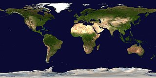
English: This spectacular “blue marble” image is the most detailed true-color image of the entire Earth to date. Using a collection of satellite-based observations, scientists and visualizers stitched together months of observations of the land surface, oceans, sea ice, and clouds into a seamless, true-color mosaic of every square kilometer (.386 square mile) of our planet. These images are freely available to educators, scientists, museums, and the public. This record includes preview images and links to full resolution versions up to 21,600 pixels across.
Much of the information contained in this image came from a single remote-sensing device-NASA’s Moderate Resolution Imaging Spectroradiometer, or MODIS. Flying over 700 km above the Earth onboard the Terra satellite, MODIS provides an integrated tool for observing a variety of terrestrial, oceanic, and atmospheric features of the Earth. The land and coastal ocean portions of these images are based on surface observations collected from June through September 2001 and combined, or composited, every eight days to compensate for clouds that might block the sensor’s view of the surface on any single day. Two different types of ocean data were used in these images: shallow water true color data, and global ocean color (or chlorophyll) data. Topographic shading is based on the GTOPO 30 elevation dataset compiled by the U.S. Geological Survey’s EROS Data Center. MODIS observations of polar sea ice were combined with observations of Antarctica made by the National Oceanic and Atmospheric Administration’s AVHRR sensor—the Advanced Very High Resolution Radiometer. The cloud image is a composite of two days of imagery collected in visible light wavelengths and a third day of thermal infra-red imagery over the poles. Global city lights, derived from 9 months of observations from the Defense Meteorological Satellite Program, are superimposed on a darkened land surface map. |
| Датум | |
| Извор | https://visibleearth.nasa.gov/view.php?id=57752 (image link) |
| Аутор | Reto Stöckli/NASA GSFC (land surface, shallow water, clouds); Robert Simmon (ocean color, compositing, 3D globes, animation); MODIS Land Group; MODIS Science Data Support Team; MODIS Atmosphere Group; MODIS Ocean Group; USGS EROS Data Center (topography); USGS Terrestrial Remote Sensing Flagstaff Field Center (Antarctica); Defense Meteorological Satellite Program (city lights). |
| Остале верзије |
|
.jpg)
.jpg)
.png)

| 360° | View in 360° panoramic viewer
|
|---|
Лиценцирање
| Ова датотека је у јавном власништву зато што је њен аутор НАСА. НАСА-а политика ауторских права наводи „Материјали НАСА-е нису заштићени ауторским правима осим ако није другачије наведено“. (Погледајте Template:PD-USGov, NASA copyright policy page или JPL Image Use Policy.) | ||
 |
Упозорења:
|
Историја датотеке
Кликните на датум/време да бисте видели тадашњу верзију датотеке.
| Датум/време | Минијатура | Димензије | Корисник | Коментар | |
|---|---|---|---|---|---|
| тренутна | 04:08, 16. април 2017. | | 21.600 × 10.800 (54,96 MB) | Huntster | Full available resolution. |
| 17:31, 14. јануар 2006. |  | 2.048 × 1.024 (233 kB) | Haham hanuka~commonswiki | http://veimages.gsfc.nasa.gov//2433/land_shallow_topo_2048.jpg Category:Earth |
Употреба датотеке
Следећа страница користи ову датотеку:
Глобална употреба датотеке
Други викији који користе ову датотеку:
- Употреба на ar.wikipedia.org
- Употреба на el.wikipedia.org
- Употреба на en.wikipedia.org
- Употреба на en.wikibooks.org
- Употреба на en.wikinews.org
- Употреба на fi.wikibooks.org
- Употреба на fr.wikipedia.org
- Употреба на id.wikipedia.org
- Употреба на pl.wikiquote.org
- Употреба на pt.wikipedia.org
- Употреба на so.wikipedia.org
- Употреба на tl.wikipedia.org
- Употреба на tr.wikipedia.org