
Датотека:Nottingham Castle Gatehouse (geograph 7313799).jpg

Оригинална датотека (1.024 × 683 пиксела, величина датотеке: 1,06 MB, MIME тип: image/jpeg)
| Ово је датотека са Викимедијине оставе. Информације са њене странице са описом приказане су испод. Викимедијина остава је складиште слободно лиценциралних мултимедијалних датотека. И Ви можете да помогнете. |
.jpg)
Опис
| Опис |
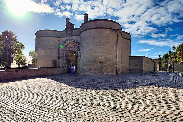
English: The Castle's original Norman construction began in 1068 and was added to extensively through the Medieval period. It was an important royal fortress and occasional royal residence during the Middle Ages. The site occupies a commanding position on a natural promontory known as "Castle Rock", with cliffs 130 feet high to the south and west which dominates the city skyline.
The original Castle was largely demolished in 1651, after the Civil War and it was replaced by a Stuart Restoration-era ducal palace in the 1670s. This was renovated in the 1870s to house an art gallery and museum, which remain in use. Little of the original castle survives other than the gatehouse and parts of the ramparts, but sufficient portions remain to give an impression of the layout of the site and it is protected as a Scheduled Ancient Monument (List Entry 1006382 Historic England). The gatehouse was built for Henry III in the 1250s. The gatehouse of the medieval castle and much of the walling of the outer bailey were retained as a garden wall for the Ducal Mansion. It was restored and a gateway was added in 1908. It is an important survivor of the medieval castle and is Listed as a Grade I listed building (List Entry 1247094 Historic England). Although the castle is owned by Nottingham City Council, it is operated by an independent charitable trust called the Nottingham Castle Trust. |
| Датум | |
| Извор | From geograph.org.uk |
| Аутор | David Dixon |
| Дозвола (Поновно коришћење ове датотеке) |
Creative Commons Attribution Share-alike license 2.0 |
| Ауторство (required by the license) | David Dixon / Nottingham Castle Gatehouse / |
| Положај камере | | Ова и друге слике снимљене у близини на: OpenStreetMap |
|---|
.jpg¶ms=052.950838_N_-001.153705_E_globe:Earth_type:camera_source:geograph-osgb36(SK5695839608)_heading:202.00&language=sr)
| Положај објекта | | Ова и друге слике снимљене у близини на: OpenStreetMap |
|---|
.jpg¶ms=052.950590_N_-001.153830_E_globe:Earth_class:object_type:object_source:geograph-osgb36(SK56953958)_heading:202.00&language=sr)
Лиценцирање

|
This image was taken from the Geograph project collection. See this photograph's page on the Geograph website for the photographer's contact details. The copyright on this image is owned by David Dixon and is licensed for reuse under the Creative Commons Attribution-ShareAlike 2.0 license.
|
- Дозвољено је:
- да делите – да умножавате, расподељујете и преносите дело
- да прерађујете – да прерадите дело
- Под следећим условима:
- ауторство – Морате да дате одговарајуће заслуге, обезбедите везу ка лиценци и назначите да ли су измене направљене. Можете то урадити на било који разуман манир, али не на начин који предлаже да лиценцатор одобрава вас или ваше коришћење.
- делити под истим условима – Ако измените, преобразите или доградите овај материјал, морате поделити своје доприносе под истом или компатибилном лиценцом као оригинал.
Историја датотеке
Кликните на датум/време да бисте видели тадашњу верзију датотеке.
| Датум/време | Минијатура | Димензије | Корисник | Коментар | |
|---|---|---|---|---|---|
| тренутна | 20:48, 2. мај 2023. | | 1.024 × 683 (1,06 MB) | Chocolateediter | == {{int:filedesc}} == {{Information |Description={{en|1=The Castle's original Norman construction began in 1068 and was added to extensively through the Medieval period. It was an important royal fortress and occasional royal residence during the Middle Ages. The site occupies a commanding position on a natural promontory known as "Castle Rock", with cliffs 130 feet high to the south and west which dominates the city skyline. The original Castle was largely demolished in 1651, after the Civ... |
Употреба датотеке
Следећа страница користи ову датотеку:
Глобална употреба датотеке
Други викији који користе ову датотеку:
- Употреба на en.wikipedia.org
.jpg)