
Датотека:PIA16554-MarsCuriosityRover-TraverseMap-20121217.jpg

Оригинална датотека (3.300 × 2.550 пиксела, величина датотеке: 1,68 MB, MIME тип: image/jpeg)
| Ово је датотека са Викимедијине оставе. Информације са њене странице са описом приказане су испод. Викимедијина остава је складиште слободно лиценциралних мултимедијалних датотека. И Ви можете да помогнете. |
Опис измене
| Опис |
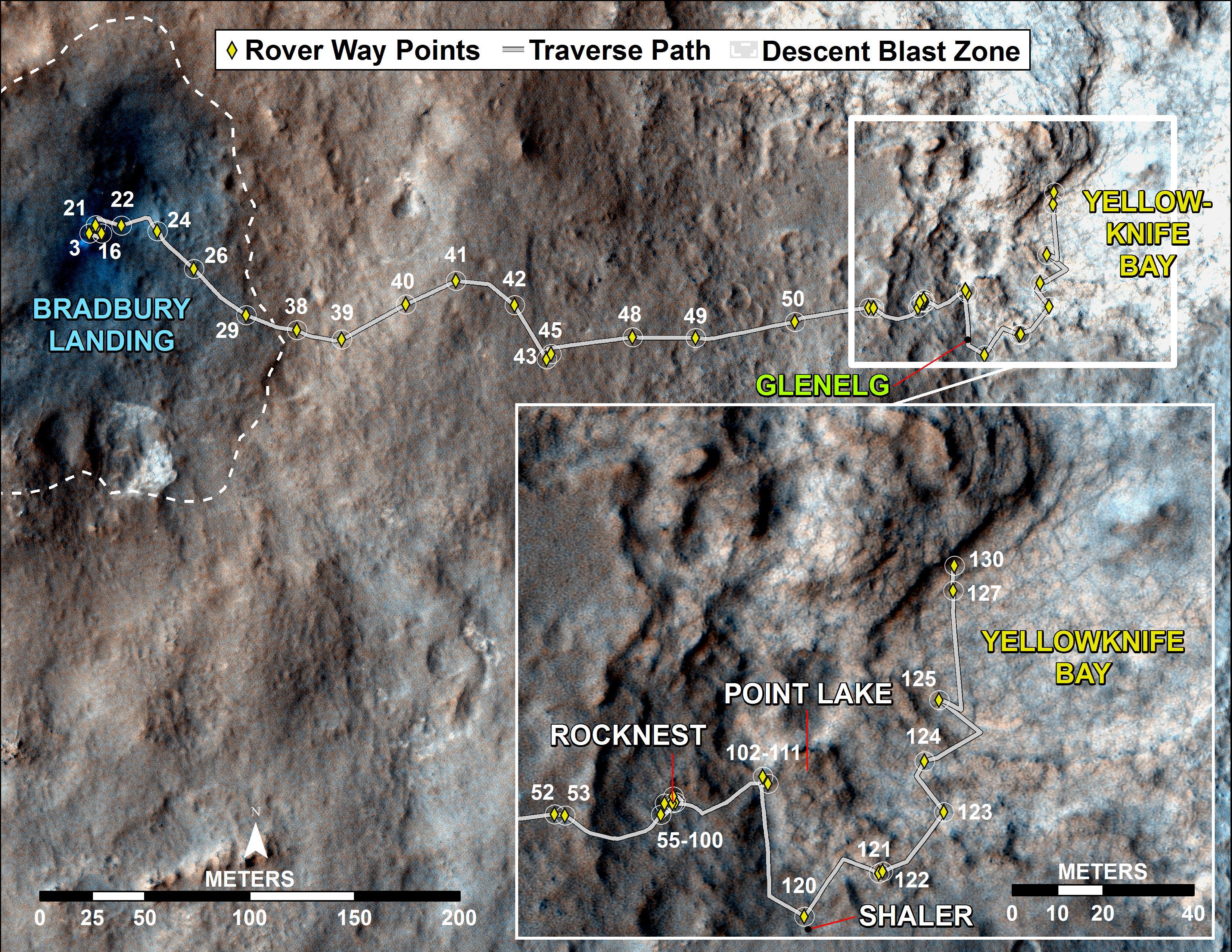
English: PIA16554: Curiosity Traverse Map, Sol 130
http://photojournal.jpl.nasa.gov/catalog/PIA16554 Target Name: Mars Is a satellite of: Sol (our sun) Mission: Mars Reconnaissance Orbiter (MRO) Mars Science Laboratory (MSL) Spacecraft: Curiosity Mars Reconnaissance Orbiter (MRO) Instrument: HiRISE Product Size: 3300 x 2550 pixels (width x height) Produced By: JPL Full-Res TIFF: PIA16554.tif (25.26 MB) Full-Res JPEG: PIA16554.jpg (1.76 MB) Click on the image above to download a moderately sized image in JPEG format (possibly reduced in size from original) Original Caption Released with Image: This map traces where NASA's Mars rover Curiosity drove between landing at a site subsequently named "Bradbury Landing," and the position reached during the mission's 130th Martian day, or sol, (Dec. 17, 2012). The inset shows the most recent legs of the traverse in greater detail. The rover entered a shallow depression called "Yellowknife Bay" with a drive of about 86 feet (26.1 meters) on Sol 125 (Dec. 12). It subsequently drove about 108 feet (32.8 meters) on Sol 127 (Dec. 14) and about 18 feet (5.6 meters) on Sol 130. Yellowknife Bay is a potential location for selection of the first target rock for Curiosity's hammering drill. The ground in this basin is a different type of terrain from the terrain Curiosity crossed getting there from Bradbury Landing. Nighttime observations from orbit indicate that the ground in the basin retains daytime heating better than the terrain around Bradbury Landing does, a property called high thermal inertia. The mapped area is within Gale Crater and north of the mountain called Mount Sharp in the middle of the crater. After the first use of the drill, the rover's main science destination will be on the lower reaches of Mount Sharp. For broader-context images of the area, see PIA16064 and PIA16058. The base image from the map is from the High Resolution Imaging Science Experiment Camera (HiRISE) in NASA's Mars Reconnaissance Orbiter. NASA's Jet Propulsion Laboratory manages the Mars Science Laboratory/Curiosity for NASA's Science Mission Directorate in Washington. The mission's Curiosity rover was designed, developed and assembled at JPL, a division of the California Institute of Technology in Pasadena. For more about NASA's Curiosity mission, visit: http://www.jpl.nasa.gov/msl, http://www.nasa.gov/mars, and http://mars.jpl.nasa.gov/msl. Image Credit: NASA/JPL-Caltech/Univ. of Arizona Image Addition Date: 2012-12-18 |
| Датум | |
| Извор | http://photojournal.jpl.nasa.gov/jpeg/PIA16554.jpg |
| Аутор | NASA/JPL-Caltech/Univ. of Arizona |
Лиценцирање
| Ова датотека је у јавном власништву зато што је њен аутор НАСА. НАСА-а политика ауторских права наводи „Материјали НАСА-е нису заштићени ауторским правима осим ако није другачије наведено“. (Погледајте Template:PD-USGov, NASA copyright policy page или JPL Image Use Policy.) | ||
 |
Упозорења:
|
Историја датотеке
Кликните на датум/време да бисте видели тадашњу верзију датотеке.
| Датум/време | Минијатура | Димензије | Корисник | Коментар | |
|---|---|---|---|---|---|
| тренутна | 17:54, 20. децембар 2012. | | 3.300 × 2.550 (1,68 MB) | Drbogdan | User created page with UploadWizard |
Употреба датотеке
Следећа страница користи ову датотеку: