
Датотека:Plan, Red River and Assiniboine in 1836 (1863).jpg

Оригинална датотека (4.200 × 5.136 пиксела, величина датотеке: 3,97 MB, MIME тип: image/jpeg)
| Ово је датотека са Викимедијине оставе. Информације са њене странице са описом приказане су испод. Викимедијина остава је складиште слободно лиценциралних мултимедијалних датотека. И Ви можете да помогнете. |
Опис измене
| Опис |
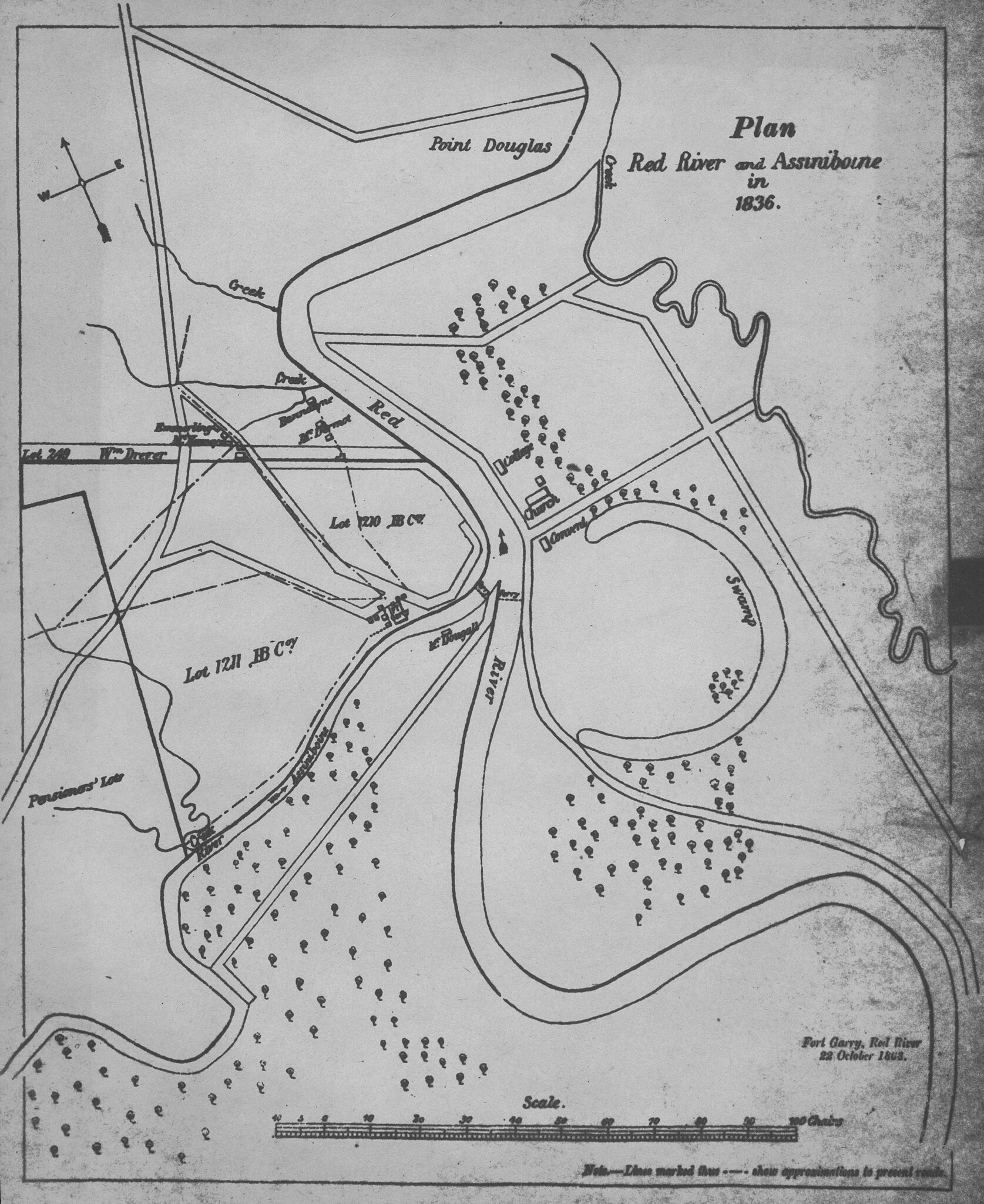
Anonymous. Plan, Red River and Assiniboine in 1836 [map]. 1:7,200. 1863. The copy the scan was made from is blurry. There is a manuscript map, ink on paper with property lines and roads coloured in the Provincial Archives of Manitoba. The provenance of this map is uncertain. Ostensibly it is a plan of Red River Settlement in 1836, with, however, further features added in 1863, particularly houses and locations of ferrys. The double lines appear to be property boundaries, and in some instances they also mark the locations of roads. The solid lines, for example those connecting the A.G.B Bannatyne home with Fort Garry, are roads which were in existence in 1863 when the map was presumably copied. Of greatest significance are the relationships of the three main components of Red River Settlement, shown as they were in 1863: (i) Fort Garry, (ii) the new centre, where George (Dutch George) Emmerling and Henry McKenney had their stores, and Bannatyne and Andrew McDermot their homes, and (iii) the French community across the river. The swamp in St. Boniface, presently drained and occupied by Enfield Crescent, is an oxbow of the Red River. (Warkentin and Ruggles. Historical Atlas of Manitoba. map 76, p. 190) Image Courtesy of University of Manitoba Archives & Special Collections |
|||
| Датум | ||||
| Извор | Plan, Red River and Assiniboine in 1836 (1863) | |||
| Аутор | Anonymous via Wyman Laliberte from Edmonton, Canada | |||
| Дозвола (Поновно коришћење ове датотеке) |
|

.jpg)
Лиценцирање
- Дозвољено је:
- да делите – да умножавате, расподељујете и преносите дело
- да прерађујете – да прерадите дело
- Под следећим условима:
- ауторство – Морате да дате одговарајуће заслуге, обезбедите везу ка лиценци и назначите да ли су измене направљене. Можете то урадити на било који разуман манир, али не на начин који предлаже да лиценцатор одобрава вас или ваше коришћење.
| This image was originally posted to Flickr by Manitoba Historical Maps at https://www.flickr.com/photos/11496488@N07/3253318777. It was reviewed on 21. април 2013. by FlickreviewR and was confirmed to be licensed under the terms of the cc-by-2.0. |
Историја датотеке
Кликните на датум/време да бисте видели тадашњу верзију датотеке.
| Датум/време | Минијатура | Димензије | Корисник | Коментар | |
|---|---|---|---|---|---|
| тренутна | 03:41, 21. април 2013. | | 4.200 × 5.136 (3,97 MB) | Geo Swan | {{Information |Description=Anonymous. Plan, Red River and Assiniboine in 1836 [map]. 1:7,200. 1863. The copy the scan was made from is blurry. There is a manuscript map, ink on paper with property lines and roads coloured in the Provincial Archives of... |
Употреба датотеке
3 следеће странице користе ову датотеку:
.jpg)