
Датотека:Illinois wind resource map 50m 800.jpg

Величина овог приказа: 463 × 599 пиксела. 3 друге резолуције: 185 × 240 пиксела | 371 × 480 пиксела | 850 × 1.100 пиксела.
Оригинална датотека (850 × 1.100 пиксела, величина датотеке: 637 kB, MIME тип: image/jpeg)
| Ово је датотека са Викимедијине оставе. Информације са њене странице са описом приказане су испод. Викимедијина остава је складиште слободно лиценциралних мултимедијалних датотека. И Ви можете да помогнете. |


Опис измене
| Опис |
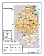
English: Average annual wind power distribution for Illinois, 50m height above ground, also showing location of existing electrical transmission lines |
| Датум | |
| Извор | http://www.windpoweringamerica.gov/images/windmaps/il_50m_800.jpg |
| Аутор | United States Department of Energy, National Renewable Energy Laboratory, TrueWind Solutions |
| Дозвола (Поновно коришћење ове датотеке) |
EERE copyright policy says its works are public domain: http://www1.eere.energy.gov/webpolicies/#copyright |
| Остале верзије | http://www.awstruewind.com/files/IL_pwr50m.pdf - more detailed commercial version |
Лиценцирање
| This image is a work of a United States Department of Energy (or predecessor organization) employee, taken or made as part of that person's official duties. As a work of the U.S. federal government, the image is in the public domain.
Please note that national laboratories operate under varying licences and some are not free. Check the site policies of any national lab before crediting it with this tag.
|

|
Историја датотеке
Кликните на датум/време да бисте видели тадашњу верзију датотеке.
| Датум/време | Минијатура | Димензије | Корисник | Коментар | |
|---|---|---|---|---|---|
| тренутна | 00:51, 15. јануар 2010. | | 850 × 1.100 (637 kB) | Funandtrvl | Newer map version from 13 May 2009 |
| 06:17, 29. јануар 2009. |  | 605 × 800 (239 kB) | Teratornis | == Summary == {{Information |Description={{en|1=Average annual wind power distribution for Illinois, 50m height above ground, also showing location of existing electrical transmission lines}} |Source=http://www.windpoweringamerica.gov/images/windmaps/il_5 |
Употреба датотеке
Нема страница које користе ову датотеку.
Глобална употреба датотеке
Други викији који користе ову датотеку: