
Датотека:Akna montes PIA00250.jpg

Veličina ovog prikaza: 360 × 599 piksela. 5 drugih rezolucija: 144 × 240 piksela | 288 × 480 piksela | 462 × 768 piksela | 616 × 1.024 piksela | 1.694 × 2.817 piksela.
Originalna datoteka (1.694 × 2.817 piksela, veličina datoteke: 1,09 MB, MIME tip: image/jpeg)
| Ovo je datoteka sa Vikimedijine ostave. Informacije sa njene stranice sa opisom prikazane su ispod. Vikimedijina ostava je skladište slobodno licenciralnih multimedijalnih datoteka. I Vi možete da pomognete. |
Opis izmene
| Opis |
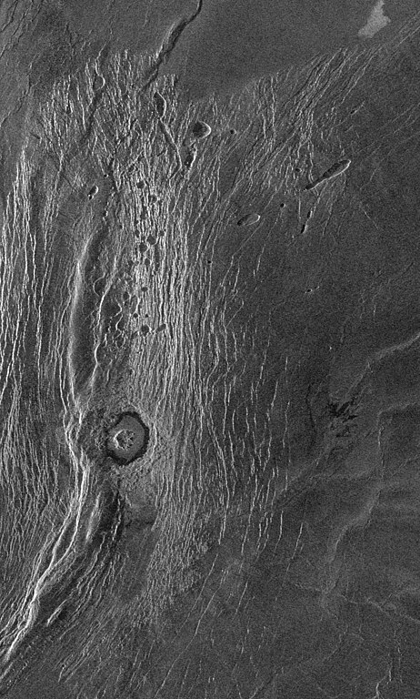
English: This Magellan full-resolution images show the northern part of the Akna Montes (mountains) of Venus. The Akna range is a north-south trending ridge belt that forms the western border of the elevated smooth plateau of Lakshmi Planum (plains). The Lakshmi plateau plains are formed by extensive volcanic eruptions and are bounded by mountain chains on all sides. The plains appear to be deformed near the mountains. This suggests that some of the mountain building activity occurred after the plains formed. An impact crater (Official International Astronomical Union name 'Wanda,' mapped first by the Soviet Venera 15/16 mission in 1984 at low resolution) with a diameter of 22 kilometers (14 miles) was formed by the impact of an asteroid in the Akna mountains. The crater has a rugged central peak and a smooth radar-dark floor, probably volcanic material. The crater does not appear to be much deformed by later crustal movement that uplifted the mountains and crumpled the plains. Material from the adjacent mountain ridge to the west, however, appears to have collapsed into the crater. Small pits seen to the north of the crater may be volcanic collapse pits a few kilometers across (1-2 miles). The ridge of the Akna mountains immediately to the west of the crater is 8 kilometers wide (5 miles). The area imaged is approximately 200 kilometers long and 125 kilometers wide (130 by 80 miles). This area is centered at 71.5 degrees north latitude, 324 degrees east longitude. The resolution of the Magellan radar system is 120 meters (400 feet). At this latitude the radar views the surface from an angle of 23 degrees off vertical, creating a perspective as though a viewer were looking at the scene from the right (east) at an angle of 23 degrees above the surface. |
| Izvor | photojournal.jpl.nasa.gov/catalog/PIA00250 |
| Autor | NASA - Jet Propulsion Laboratory |
| Dozvola (Ponovno korišćenje ove datoteke) |
Permission |
Licenciranje
| Ова датотека је у јавном власништву зато што је њен аутор НАСА. НАСА-а политика ауторских права наводи „Материјали НАСА-е нису заштићени ауторским правима осим ако није другачије наведено“. (Погледајте Template:PD-USGov, NASA copyright policy page или JPL Image Use Policy.) | ||
 |
Упозорења:
|
Istorija datoteke
Kliknite na datum/vreme da biste videli tadašnju verziju datoteke.
| Datum/vreme | Minijatura | Dimenzije | Korisnik | Komentar | |
|---|---|---|---|---|---|
| trenutna | 08:04, 7. april 2008. | | 1.694 × 2.817 (1,09 MB) | Bryan Derksen | {{Information |Description={{en|This Magellan full-resolution images show the northern part of the Akna Montes (mountains) of Venus. The Akna range is a north-south trending ridge belt that forms the western border of the elevated smooth plateau of Lakshm |
Upotreba datoteke
Sledeća stranica koristi ovu datoteku:
Globalna upotreba datoteke
Drugi vikiji koji koriste ovu datoteku:
- Upotreba na ar.wikipedia.org
- Upotreba na bg.wikipedia.org
- Upotreba na ca.wikipedia.org
- Upotreba na ce.wikipedia.org
- Upotreba na en.wikipedia.org
- Upotreba na en.wikiversity.org
- Upotreba na es.wikipedia.org
- Upotreba na eu.wikipedia.org
- Upotreba na fi.wikipedia.org
- Upotreba na fr.wikipedia.org
- Upotreba na gl.wikipedia.org
- Upotreba na hi.wikipedia.org
- Upotreba na it.wikipedia.org
- Upotreba na nl.wikipedia.org
- Upotreba na pl.wikipedia.org
- Upotreba na ta.wikipedia.org
- Upotreba na www.wikidata.org
- Upotreba na zh.wikipedia.org