
Датотека:Constanta romania.jpg
Veličina ovog prikaza: 395 × 599 piksela. 5 drugih rezolucija: 158 × 240 piksela | 316 × 480 piksela | 506 × 768 piksela | 675 × 1.024 piksela | 2.000 × 3.032 piksela.
Originalna datoteka (2.000 × 3.032 piksela, veličina datoteke: 2,11 MB, MIME tip: image/jpeg)
| Ovo je datoteka sa Vikimedijine ostave. Informacije sa njene stranice sa opisom prikazane su ispod. Vikimedijina ostava je skladište slobodno licenciralnih multimedijalnih datoteka. I Vi možete da pomognete. |
| Opis |
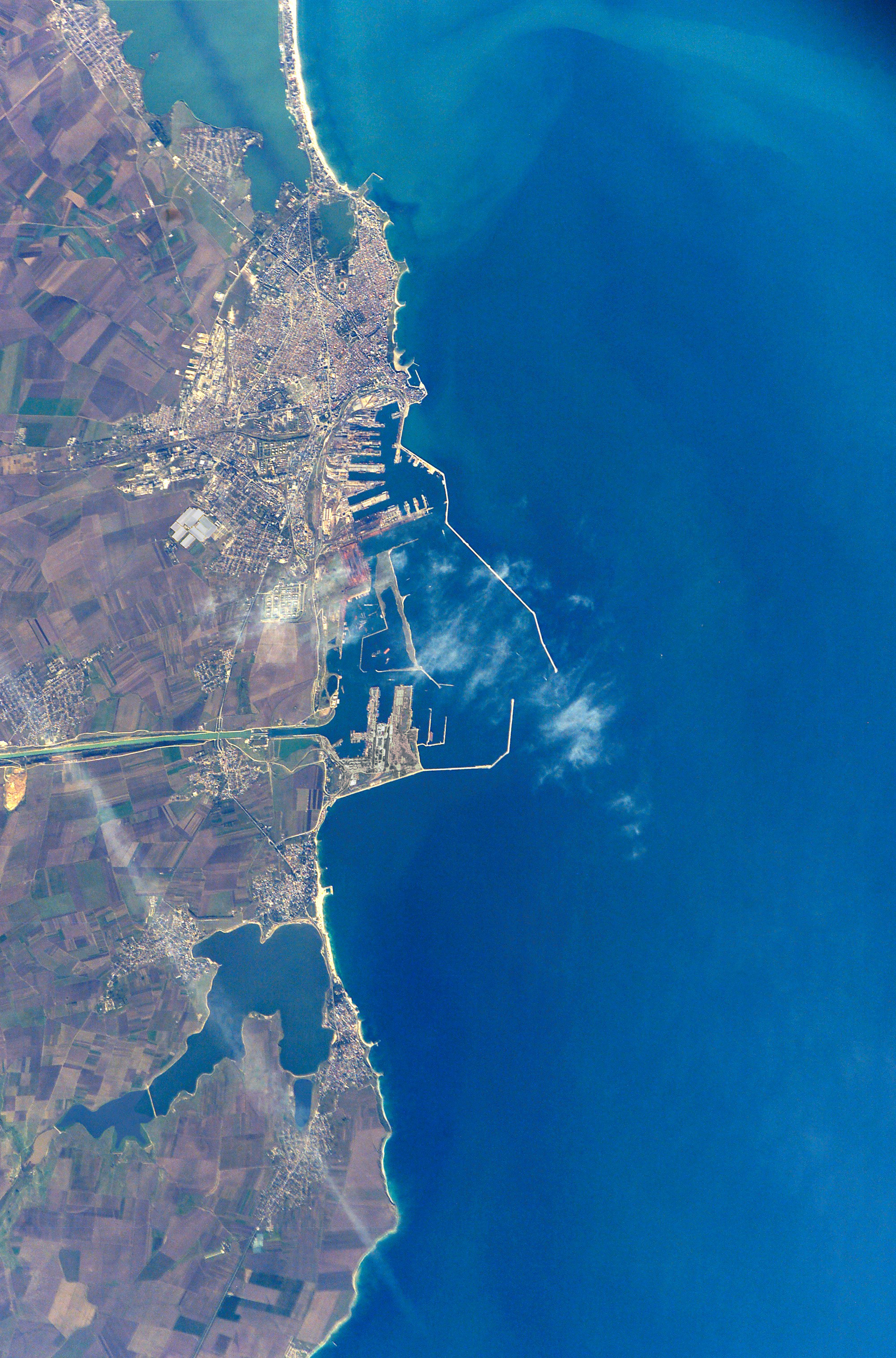
English: The modern city of Constanţa, with a population of more than 348,000, is located on the western coast of the Black Sea and is the principal seaport for Romania. It is the site of the ancient Greek city of Tomis, colonized in the 6th century B.C. In the 1st century A.D. Tomis became a flourishing provincial capital of the Roman Empire when it acquired its current name from the emperor Constantine I. Today, Constanta is a thriving port-of-entry for Romania, offering both tourist attractions and an expanding, modern port facility that is among the largest on the Black Sea. The crew of STS-112 acquired this detailed digital image of the city on October 17, 2002, using a 400-mm lens. The older part of the city is situated near the large coastal lagoon to the north, while to the south the port facilities are connected to the Danube River’s import shipping commerce via the 64-km Danube – Black Sea Canal. Agricultural fields of mostly wheat and barley extend almost to the shorelines. |
|||||
| Datum | ||||||
| Izvor | NASA - Earth From Space | |||||
| Autor | NASA - Earth From Space | |||||
| Dozvola (Ponovno korišćenje ove datoteke) |
|

| Положај камере | | Ова и друге слике снимљене у близини на: OpenStreetMap |
|---|
Istorija datoteke
Kliknite na datum/vreme da biste videli tadašnju verziju datoteke.
| Datum/vreme | Minijatura | Dimenzije | Korisnik | Komentar | |
|---|---|---|---|---|---|
| trenutna | 17:55, 9. januar 2017. | | 2.000 × 3.032 (2,11 MB) | Julieta39 | contrast |
| 06:42, 7. oktobar 2008. |  | 2.000 × 3.032 (1,71 MB) | Kimse | Larger resolution from the same source | |
| 18:25, 19. jun 2006. |  | 540 × 768 (249 kB) | Darwinek |
Upotreba datoteke
Sledeća stranica koristi ovu datoteku:
Globalna upotreba datoteke
Drugi vikiji koji koriste ovu datoteku:
- Upotreba na bg.wikipedia.org
- Upotreba na ca.wikipedia.org
- Upotreba na de.wikipedia.org
- Upotreba na en.wikipedia.org
- Upotreba na fr.wikipedia.org
- Upotreba na hu.wikipedia.org
- Upotreba na id.wikipedia.org
- Upotreba na mk.wikipedia.org
- Upotreba na ro.wikipedia.org
- Upotreba na ru.wikipedia.org
- Upotreba na sq.wikipedia.org
- Upotreba na tr.wikipedia.org
- Upotreba na uk.wikipedia.org
- Upotreba na ur.wikipedia.org
- Upotreba na zh.wikipedia.org