
Датотека:Languages of CE Europe-3.PNG
Veličina ovog prikaza: 524 × 599 piksela. 3 druge rezolucije: 210 × 240 piksela | 419 × 480 piksela | 951 × 1.088 piksela.
Originalna datoteka (951 × 1.088 piksela, veličina datoteke: 769 kB, MIME tip: image/png)
| Ovo je datoteka sa Vikimedijine ostave. Informacije sa njene stranice sa opisom prikazane su ispod. Vikimedijina ostava je skladište slobodno licenciralnih multimedijalnih datoteka. I Vi možete da pomognete. |
Opis izmene
| Opis |
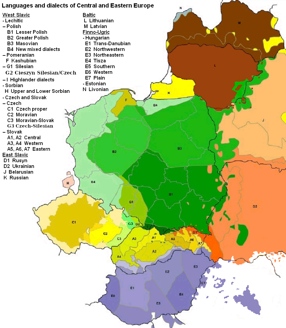
English: Map of languages and dialects of Central and Eastern Europe
Polski: Języki i dialekty Europy Srodkowo-Wschodniej
Deutsch: Legende:
|
||
| Datum | |||
| Izvor |
Sopstveno delo |
||
| Autor | |||
| Ostale verzije |
|

|
Ова linguistic map слика требало би да буду поново израђене као векторска графика у SVG формату. Тиме се остварује неколико предности. Више информација потражите на Commons:Media for cleanup. Ако је ова слика већ доступна у SVG формату, отпремите је. Након отпремања датотеке, овај шаблон замените шаблоном {{vector version available|new image name.svg}}.
|
Licenciranje

|
Data je dozvola da se kopira, distribuira i/ili menja ovaj dokument pod uslovima GNU-ove licence za slobodnu dokumentaciju, verzije 1.2 ili bilo koje novije verzije koju objavi Zadužbina za slobodni softver; bez nepromenljivih odeljaka i bez teksta na naslovnoj i zadnjoj strani. Tekst licence možete pročitati ovde. |
| Ova datoteka je dostupna pod licencom Creative Commons Autorstvo-Deliti pod istim uslovima 3.0 Unported. | ||
| Autorstvo: Zaragoza, Kpalion, Dellijks | ||
| ||
| Ova licenca je dodata na ovu datoteku kao deo ažuriranja GFDL licence. |
Prvobitan dnevnik otpremanja
This image is a derivative work of the following images:
- File:Languages_of_CE_Europe.PNG licensed with GFDL
- 2008-08-25T20:42:18Z Kpalion 951x1088 (1053557 Bytes) {{Information |Description={{en|Map of languages and dialects of Central and Eastern Europe}} |Source=*[[:Image:Jezyki_i_dialekty_Europa_Srodkowo_Wsch..jpg|]] |Date=2008-08-25 20:40 (UTC) |Author=*derivative work: ~~~ *[[:Ima
Istorija datoteke
Kliknite na datum/vreme da biste videli tadašnju verziju datoteke.
| Datum/vreme | Minijatura | Dimenzije | Korisnik | Komentar | |
|---|---|---|---|---|---|
| trenutna | 08:47, 17. avgust 2019. | | 951 × 1.088 (769 kB) | D T G | G1 - changed western border (compare my other map: File:Gwary śląskie wg Zaręby.png - sources there); G2 - changed name and classification (this was part of the Polish Cieszyn Silesian, after 1920 evolving towards Czech, but it was absurd that it would be classified as Czech when to South-West was just G1, not differentiated from G1 in Poland! I repeat it was absurd!, therefore I created G3, see below); G3 - created Czech-Silesian also know as Lach dialects, up to 1980s regarded by some... |
| 09:42, 17. avgust 2015. |  | 951 × 1.088 (928 kB) | Winnetou14 | Reverted to version as of 19:28, 13 September 2009 | |
| 01:11, 12. novembar 2009. |  | 951 × 1.088 (697 kB) | Alex Tora | {{Information |Description= |Source={{own}} |Date= |Author=Alex Tora |Permission= |other_versions= }} | |
| 21:28, 13. septembar 2009. |  | 951 × 1.088 (928 kB) | Scooter20 | Fixed Hungarian & Ukrainian in Romania, Ukrainian in Moldova and Romanian in Hungary and Ukraine | |
| 00:16, 20. jul 2009. |  | 951 × 1.088 (982 kB) | Dellijks | {{Information |Description={{en|Map of languages and dialects of Central and Eastern Europe}}{{pl|Języki i dialekty Europy Srodkowo-Wschodniej}} {{de|-> * B1 - Kleinpolnisch * B2 - Großpolnisch * B3 - Masowisch * B4 - Hochpolnisch * F - Kaschubisch * G1 |
Upotreba datoteke
Sledeća stranica koristi ovu datoteku:
Globalna upotreba datoteke
Drugi vikiji koji koriste ovu datoteku:
- Upotreba na af.wikipedia.org
- Upotreba na als.wikipedia.org
- Upotreba na am.wikipedia.org
- Upotreba na ang.wikipedia.org
- Upotreba na an.wikipedia.org
- Upotreba na arz.wikipedia.org
- Upotreba na ast.wikipedia.org
- Upotreba na bo.wikipedia.org
- Upotreba na br.wikipedia.org
- Upotreba na csb.wikipedia.org
- Upotreba na cs.wikipedia.org
- Upotreba na cv.wikipedia.org
- Upotreba na da.wikipedia.org
- Upotreba na de.wikipedia.org
- Upotreba na diq.wikipedia.org
- Upotreba na el.wikipedia.org
- Upotreba na en.wikipedia.org
- Upotreba na en.wiktionary.org
- Upotreba na eo.wikipedia.org
- Upotreba na eu.wikipedia.org
- Upotreba na frr.wikipedia.org
- Upotreba na fr.wikipedia.org
- Upotreba na fur.wikipedia.org
- Upotreba na fy.wikipedia.org
- Upotreba na gd.wikipedia.org
- Upotreba na he.wikipedia.org
- Upotreba na hr.wikipedia.org
- Upotreba na hsb.wikipedia.org
- Upotreba na hy.wikipedia.org
- Upotreba na incubator.wikimedia.org
- Upotreba na ka.wikipedia.org
- Upotreba na ko.wikipedia.org
- Upotreba na la.wikipedia.org
- Upotreba na mg.wikipedia.org
- Upotreba na ms.wikipedia.org
- Upotreba na nl.wikipedia.org
Još globalnog korišćenja ove datoteke.