
Датотека:Michigan Basin 2.jpg
Michigan_Basin_2.jpg (357 × 360 piksela, veličina datoteke: 47 kB, MIME tip: image/jpeg)
| Ovo je datoteka sa Vikimedijine ostave. Informacije sa njene stranice sa opisom prikazane su ispod. Vikimedijina ostava je skladište slobodno licenciralnih multimedijalnih datoteka. I Vi možete da pomognete. |
Opis izmene
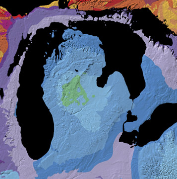
A geological map of the Michigan Basin.
Source: Michigan Basin archive copy at the Wayback Machine, The North American Tapestry of Time and Terrain, United States Department of the Interior. Text from this web page follows below.
A giant incomplete bull's-eye is centered on the state of Michigan. Radiating outward to Ohio, Indiana, Illinois, Wisconsin, and Ontario, this annular pattern outlines the Michigan Basin. The Basin is a bowl-shaped structure of uncertain origin that contains over 2.5 miles (4 km) of inward-dipping Paleozoic strata and a veneer of Jurassic sedimentary rocks. This curious basin is located in the less tectonically-active interior of the continent, bordered by the Appalachian and Rocky Mountains. It subsided rapidly from Cambrian to Silurian time and filled with shallow-water marine sediments, some of which contain deposits of petroleum, coal, and salt.
Licenciranje
Овај рад је у јавном власништву, зато што је дело савезне владе Сједињених Америчких Држава по наслову 17 поглавље 1 одељак 105 законика САД-а. Погледајте ауторско право.
Напомена: ово важи само за дела америчке савезне владе не важи за дела америчких савезних држава, територија, комонвелта, округа, општина или било ког другог одсека. Ова ознака такође не важи за поштанске марке издате после 1978. године од стране Поште САД-а. Ово такође не важи за неке кованице америчког долара, за више информација погледајте услове коришћења кованица америчког долара.
|
 | |
| Utvrđeno je da ova datoteka nije ograničena u pogledu autorskih prava, uključujući i sva srodna i susedna prava. | ||
Istorija datoteke
Kliknite na datum/vreme da biste videli tadašnju verziju datoteke.
| Datum/vreme | Minijatura | Dimenzije | Korisnik | Komentar | |
|---|---|---|---|---|---|
| trenutna | 13:29, 15. jun 2007. | | 357 × 360 (47 kB) | Avenue | A geological map of the Michigan Basin. Source: [http://nationalatlas.gov/articles/geology/features/michiganbasin.html Michigan Basin], The North American Tapestry of Time and Terrain, United States Department of the Interior. Text from this web page fo |
Upotreba datoteke
Sledeća stranica koristi ovu datoteku:
Globalna upotreba datoteke
Drugi vikiji koji koriste ovu datoteku:
- Upotreba na ar.wikipedia.org
- Upotreba na en.wikipedia.org
- Upotreba na en.wikibooks.org
- Upotreba na it.wikipedia.org
- Upotreba na ru.wikipedia.org
- Upotreba na sh.wikipedia.org
- Upotreba na sv.wikipedia.org
- Upotreba na www.wikidata.org