
Датотека:WW2-Holocaust-Poland.PNG
Veličina ovog prikaza: 557 × 600 piksela. 5 drugih rezolucija: 223 × 240 piksela | 446 × 480 piksela | 713 × 768 piksela | 951 × 1.024 piksela | 2.007 × 2.161 piksela.
Originalna datoteka (2.007 × 2.161 piksela, veličina datoteke: 1,34 MB, MIME tip: image/png)
| Ovo je datoteka sa Vikimedijine ostave. Informacije sa njene stranice sa opisom prikazane su ispod. Vikimedijina ostava je skladište slobodno licenciralnih multimedijalnih datoteka. I Vi možete da pomognete. |

|
Ова map слика требало би да буду поново израђене као векторска графика у SVG формату. Тиме се остварује неколико предности. Више информација потражите на Commons:Media for cleanup. Ако је ова слика већ доступна у SVG формату, отпремите је. Након отпремања датотеке, овај шаблон замените шаблоном {{vector version available|new image name.svg}}.
|
Opis izmene
| Opis |
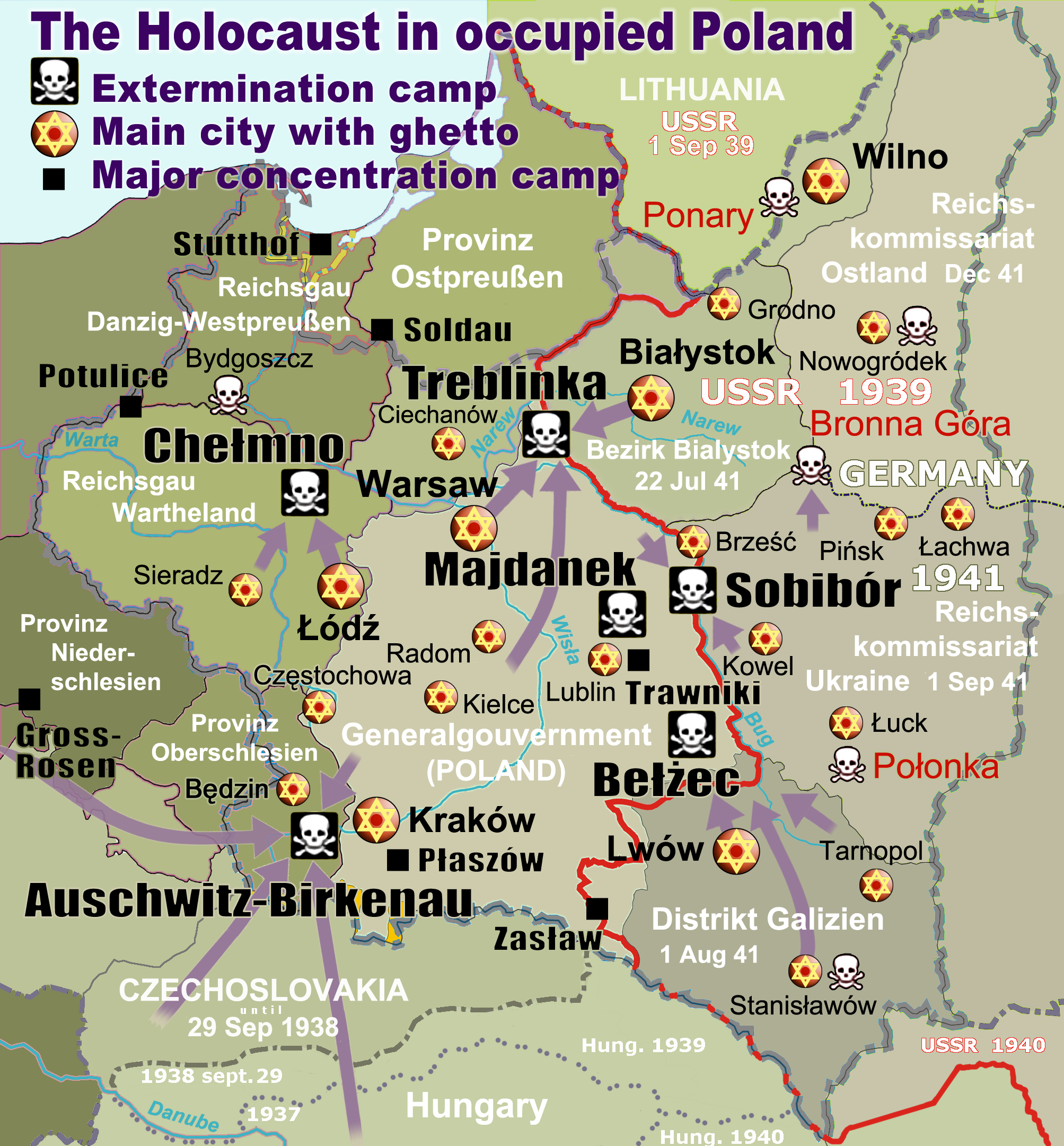
English: Map of the Holocaust in occupied Poland during World War II. The outline shows the borders of the Second Polish Republic at the time of the Nazi-German-and-Soviet invasion of Poland in 1939 with demarcation line between the two invading armies marked in red. Internal boundaries show the administrative divisions of occupied territories imposed by Nazi Germany when the Final Solution was set in motion during and after Operation Barbarossa of 1941. This map shows all Nazi German extermination camps (or death camps), as well as prominent concentration, labour and prison camps, major pre-WW2 Polish cities with the new Jewish ghettos set up by Nazi Germany, major deportation routes, and major massacre sites. Notes: 1. Extermination camps – marked with white skulls in black squares – are six dedicated facilities used for the mass gassings of prisoners, but all camps and ghettos took a toll of many, many lives. 2. Concentration camps – marked with black squares – feature only the most notorious forced-labor camps, prison camps & transit camps. 3. Sites of mass shootings into remote ravines – marked with white skulls – include Bronna Góra, Ponary and others. They were utilized during the 'Holocaust by bullets'. 4. Destruction ghettos – marked with Yellow stars in red circles – existed in most Polish cities. Only a selection is shown. 5. Major deportation routes travelled by the Holocaust trains are marked with RosyBrown arrows. 6. Most camps & ghettos which are not well known have been excluded for clarity. 7. District borders are at the height of Axis domination (1942). 8. Regions have German designations (e.g. "Ostland"), with the country name denoted in uppercase letters, e.g. LITHUANIA, CZECHOSLOVAKIA, or in parenthesis below the German occupational designation, e.g. (POLAND). |
| Datum | |
| Izvor |
Sopstveno delo. Composite map derived from a variety of readily available sources which may or may not include:
|
| Autor |
|
| Dozvola (Ponovno korišćenje ove datoteke) |
PD, see below. The map is completely unrestricted for any Wikipedia/Wikimedia project. |
| Ostale verzije |
[]
|


.png)


.png)


Licenciranje
For all derivative works of maps uploaded earlier see below.
Poeticbent (en), nosilac autorskog prava nad ovim delom, objavljuje isto pod sledećom licencom:
| Ja, tvorac ovog dela, predajem ga u javno vlasništvo. Ovo se odnosi na ceo svet. U nekim zemljama, ovo nije zakonski moguće; u tom slučaju: Ja, tvorac ovog dela dozvoljavam svakome da koristi ovo delo za bilo koju namenu, bez bilo kakvih uslova, osim uslova koje nameće zakon. |
- File uploaded previously
Dennis Nilsson, nosilac autorskog prava nad ovim delom, objavljuje isto pod sledećom licencom:
Ova datoteka je dostupna pod licencom Creative Commons Autorstvo 3.0 Unported.
Autorstvo: Dennis Nilsson
- Dozvoljeno je:
- da delite – da umnožavate, raspodeljujete i prenosite delo
- da prerađujete – da preradite delo
- Pod sledećim uslovima:
- autorstvo – Morate da date odgovarajuće zasluge, obezbedite vezu ka licenci i naznačite da li su izmene napravljene. Možete to uraditi na bilo koji razuman manir, ali ne na način koji predlaže da licencator odobrava vas ili vaše korišćenje.
Derivative work: Piotr Konieczny aka Prokonsul Piotrus Talk Derivative works of this file:
Derivative work: User:Poeticbent (Talk) Derivative works of this file:
- Uploaded previously
| Ово је ретуширана слика, што значи да је дигитално измењена у односу на своју изворну верзију. Измене: Smaller version: occupied Poland only (pre-WWII borders). Изворна верзија се може видети овде: WW2-Holocaust-Europe.png.
|
Ja, nosilac autorskog prava nad ovim delom, objavljujem isto pod sledećom licencom:
Ova datoteka je dostupna pod licencom Creative Commons Autorstvo 3.0 Unported.
- Dozvoljeno je:
- da delite – da umnožavate, raspodeljujete i prenosite delo
- da prerađujete – da preradite delo
- Pod sledećim uslovima:
- autorstvo – Morate da date odgovarajuće zasluge, obezbedite vezu ka licenci i naznačite da li su izmene napravljene. Možete to uraditi na bilo koji razuman manir, ali ne na način koji predlaže da licencator odobrava vas ili vaše korišćenje.
Prvobitan dnevnik otpremanja
For derivative works of the first uploaded file created by User:Dna-webmaster see the following:
- File:WW2-Holocaust-Europe.png licensed with Cc-by-3.0
Uploaded with derivativeFX
Istorija datoteke
Kliknite na datum/vreme da biste videli tadašnju verziju datoteke.
| Datum/vreme | Minijatura | Dimenzije | Korisnik | Komentar | |
|---|---|---|---|---|---|
| trenutna | 17:46, 10. mart 2020. | | 2.007 × 2.161 (1,34 MB) | Claude Zygiel | Cosmetics |
| 22:33, 28. mart 2018. |  | 2.007 × 2.161 (1,48 MB) | Poeticbent | not an improvement: img looks muddy but I have original Photoshop layers, and can adjust them individually; comment on specifics in talk please | |
| 19:48, 27. mart 2018. |  | 2.007 × 2.161 (1,49 MB) | Hohum | Too much information competing for attention in a very busy image. Toned down region name brightness, desaturated slightly. | |
| 07:38, 10. jul 2017. |  | 2.007 × 2.161 (1,48 MB) | Poeticbent | vital updates following a discussion → prominent ghettos, legend | |
| 21:43, 25. jul 2015. |  | 2.007 × 2.161 (1,46 MB) | Poeticbent | name of settlement: Górka Połonka, source Wolyn.ovh.org | |
| 20:27, 2. decembar 2014. |  | 2.007 × 2.161 (1,46 MB) | Poeticbent | added one missing marker | |
| 21:17, 7. maj 2014. |  | 2.007 × 2.161 (1,45 MB) | Poeticbent | location of Bronna Góra | |
| 19:34, 4. april 2014. |  | 2.007 × 2.161 (1,44 MB) | Poeticbent | Lachwa Ghetto location | |
| 23:31, 27. jun 2013. |  | 2.007 × 2.161 (1,42 MB) | Poeticbent | major expansion with similar color-scheme | |
| 05:09, 28. jun 2011. |  | 364 × 339 (123 kB) | LMK3 | changed the color of the Soviet Curzon line to indicate the two different occupation zones before Operation Barbarossa, refined the location of Warsaw |
Upotreba datoteke
5 sledećih stranica koristi ovu datoteku:
Globalna upotreba datoteke
Drugi vikiji koji koriste ovu datoteku:
- Upotreba na ar.wikipedia.org
- Upotreba na azb.wikipedia.org
- Upotreba na az.wikipedia.org
- Upotreba na bg.wikipedia.org
- Upotreba na bn.wikipedia.org
- Upotreba na br.wikipedia.org
- Upotreba na ca.wikipedia.org
- Upotreba na cs.wikipedia.org
- Upotreba na cs.wikibooks.org
- Upotreba na da.wikipedia.org
- Upotreba na de.wikipedia.org
- Upotreba na el.wikipedia.org
- Γκέτο της Τσενστοχόβα
- Γκέτο του Μπέντζιν
- Γκέτο του Μίζοτς
- Μπρόνα Γκούρα
- Γκέτο της Κρακοβίας
- Γκέτο του Μπζέσκο
- Στρατόπεδο συγκέντρωσης Τραβνίκι
- Στρατόπεδο συγκέντρωσης Ποτουλίτσε
- Γκέτο του Σοσνόβιετς
- Γκέτο του Ντροχόμπιτς
- Γκέτο του Ταρνόπολ
- Ιστορία των Εβραίων στην Πολωνία
- Γκέτο του Σιέντλτσε
- Γκέτο της Γουόμζα
- Γκέτο του Γκορλίτσε
- Γκέτο του Μπιαουίστοκ
- Γκέτο του Μπζεστς
- Γκέτο του Ράντομ
- Γκέτο του Νόβι Σοντς
Još globalnog korišćenja ove datoteke.