
Индигирка — разлика између измена
м →top: померање шаблона к врху |
. |
||
| Ред 1: | Ред 1: | ||
{{Short description|Река у Јакутији, Русија}} |
|||
{{Без извора|датум=јун 2022}} |
|||
{{Река |
{{Река |
||
| име = Индигирка |
| име = Индигирка |
||
| Ред 22: | Ред 22: | ||
}} |
}} |
||
'''Индигирка''' ({{јез-ру|Индигирка}}) је река у [[Јакутија|Јакутији]] у источном делу [[Русија|Русије]]. Налази се између река [[Јана (река)|Јана]] и [[Колима (река)|Колима]]. Дуга је 1.726 km, а њен слив покрива 360.000 km². Улива се широком делтом у залив [[Колима (залив)|Колима]] који припада [[Северни ледени океан|Северном леденом океану]]. Река Индигирка се замрзава у октобру и остаје под ледом до маја или јуна. Највеће насеље на реци је град [[Уст-Нера]]. |
'''Индигирка''' ({{јез-ру|Индигирка}}) је река у [[Јакутија|Јакутији]] у источном делу [[Русија|Русије]]. Налази се између река [[Јана (река)|Јана]]<ref>{{Cite journal |url=https://www.biorxiv.org/content/10.1101/448829v1 |doi = 10.1101/448829 |title = The population history of northeastern Siberia since the Pleistocene |year = 2018 |last1 = Sikora |first1 = Martin |last2 = Pitulko |first2 = Vladimir V. |last3 = Sousa |first3 = Vitor C. |last4 = Allentoft |first4 = Morten E. |last5 = Vinner |first5 = Lasse |last6 = Rasmussen |first6 = Simon |last7 = Margaryan |first7 = Ashot |last8 = De Barros Damgaard |first8 = Peter |last9 = de la Fuente Castro |first9 = Constanza |last10 = Renaud |first10 = Gabriel |last11 = Yang |first11 = Melinda |last12 = Fu |first12 = Qiaomei |last13 = Dupanloup |first13 = Isabelle |last14 = Giampoudakis |first14 = Konstantinos |last15 = Bravo Nogues |first15 = David |last16 = Rahbek |first16 = Carsten |last17 = Kroonen |first17 = Guus |last18 = Peyrot |first18 = Michäel |last19 = McColl |first19 = Hugh |last20 = Vasilyev |first20 = Sergey V. |last21 = Veselovskaya |first21 = Elizaveta |last22 = Gerasimova |first22 = Margarita |last23 = Pavlova |first23 = Elena Y. |last24 = Chasnyk |first24 = Vyacheslav G. |last25 = Nikolskiy |first25 = Pavel A. |last26 = Grebenyuk |first26 = Pavel S. |last27 = Fedorchenko |first27 = Alexander Yu. |last28 = Lebedintsev |first28 = Alexander I. |last29 = Slobodin |first29 = Sergey B. |last30 = Malyarchuk |first30 = Boris A. |s2cid = 91983065 |display-authors = 29 |archive-url=https://web.archive.org/web/20190501233156/https://www.biorxiv.org/content/10.1101/448829v1 |archive-date=1 May 2019 |url-status=dead}}</ref> и [[Колима (река)|Колима]].<ref>{{cite web|url=http://www.r-arcticnet.sr.unh.edu/v4.0/ViewPoint.pl?Point=5952|title=Kolyma At Kolymskoye|publisher=R-ARCTICNET|access-date=2017-08-11}}</ref><ref name="waterrussia">{{cite web |title=Кулу |url=https://water-rf.ru/%D0%92%D0%BE%D0%B4%D0%BD%D1%8B%D0%B5_%D0%BE%D0%B1%D1%8A%D0%B5%D0%BA%D1%82%D1%8B/1327/%D0%9A%D1%83%D0%BB%D1%83 |website=Вода Россия |access-date=4 January 2022 |language=ru |trans-title=Ayan-Yuryakh }}</ref> Дуга је 1.726 km, а њен слив покрива 360.000 km². Улива се широком делтом у залив [[Колима (залив)|Колима]] који припада [[Северни ледени океан|Северном леденом океану]]. Река Индигирка се замрзава у октобру и остаје под ледом до маја или јуна. Највеће насеље на реци је град [[Уст-Нера]]. Дугачка је {{convert|1726|km|mi}}. Површина њеног [[drainage basin|басена]] је {{convert|360000|km2|mi2}}.<ref name=gvr>{{GVR|259998|Река ИНДИГИРКА}}</ref> |
||
== Историја == |
|||
{{рут}} |
|||
The isolated village of [[Russkoye Ustye]],<ref name="2016Est">Sakha Republic (Yakutia) Territorial Branch of the [[Russian Federal State Statistics Service|Federal State Statistics Service]]. [http://sakha.gks.ru/wps/wcm/connect/rosstat_ts/sakha/resources/92049f804c5c75979146937dff7d05ed/d2_032016.xls Численность населения по районам республики на 1 января 2016 года] </ref><ref name="2010Census">Sakha Republic Territorial Branch of the [[Russian Federal State Statistics Service|Federal State Statistics Service]]. Results of the 2010 All-Russian Census. [http://sakha.gks.ru/wps/wcm/connect/rosstat_ts/sakha/resources/4c22eb804e8ba4699a749f7904886701/01-05.xls Численность населения по районам, городским и сельским населённым пунктам] (''Population Counts by Districts, Urban and Rural Inhabited Localities'') </ref><ref name="History">А. И. Гоголев. "История Якутии: обзор исторических событий до начала ХХ в." (A. I. Gogolev. [http://www.ysu.ru/facultet/kfi/books/HistoryOfYakutiya.htm History of Yakutia: Review of Historical Events to the beginning of the 20th century] {{webarchive|url=https://web.archive.org/web/20050527010736/http://www.ysu.ru/facultet/kfi/books/HistoryOfYakutiya.htm |date=May 27, 2005 }}) Yakutsk, 1999.</ref> located on the [[River delta|delta]] of the Indigirka, is known for the unique traditional culture of the Russian settlers whose ancestors came there several centuries ago. Some historians have speculated that Russkoye Ustye was settled by [[Pomors]] in the early 17th century.<ref>Tatyana Bratkova [http://magazines.russ.ru/novyi_mi/1998/4/brat.html "Russkoye Ustye"]. ''[[Novy Mir]],'' 1998, no. 4 </ref> |
|||
In 1638 explorer Ivan Rebrov reached the Indigirka.<ref name= Lantzeff>{{cite book |
|||
| last = Lantzeff |
|||
| first = George V., and Richard A. Pierce |
|||
| title = Eastward to Empire: Exploration and Conquest on the Russian Open Frontier, to 1750 |
|||
| publisher = McGill-Queen's U.P. |
|||
| year = 1973 |
|||
| location = Montreal |
|||
}}</ref> In 1636–42 Elisei Buza pioneered the overland route to the Indigirka river system. At about the same time, Poznik Ivanov ascended a tributary of the lower Lena, crossed the Verkhoyansk Range to the upper Yana, and then crossed the [[Chersky Range]] to the Indigirka. In 1642 [[Mikhail Stadukhin]] reached the Indigirka overland from the Lena.<ref name=Lantzeff/> |
|||
[[Zashiversk]] on the Indigirka was an important colonial outpost during the early days of Russian colonization.<ref>{{cite web | url=http://ilin-yakutsk.narod.ru/1999-12/70.htm | title=Missionerstvo v Yakutskom krae (Миссионерство в Якутском крае) | author=Grigory Popov | year=1999 | publisher=[[Ilin (magazine)|Ilin]] | language=ru | access-date=2009-10-17 }}</ref><ref>{{cite web | url=http://ilin-yakutsk.narod.ru/2003-2/94.htm | author=Maria Starostina | language=ru | publisher=[[Ilin (magazine)|Ilin]] | year=2003 | title=Srednekolymskaya Pokrovskaya tserkov (Среднеколымская Покровская церковь) | access-date=17 October 2009 }}</ref> It was subsequently abandoned in the 19th century. Other historical settlements, now long abandoned, were Podshiversk and Uyandinskoye Zimov'ye.<ref name=MOMS>{{cite web | url=http://www.nature.ykt.ru/RIAC/OOPT_RS_(new)/Parki/Momsky_park.htm | title=Momsky natural park | language=ru | publisher=Ministry of environment preservation of [[Sakha Republic]] | access-date=2009-10-16 | archive-url=https://web.archive.org/web/20080917053218/http://www.nature.ykt.ru/RIAC/OOPT_RS_(new)/Parki/Momsky_park.htm | archive-date=2008-09-17 | url-status=dead }}</ref><ref>{{cite web | url=http://www.vsp.ru/culture/2004/11/20/437583 | title=U kazhdogo muzeya svoya sudba (У каждого музея своя судьба) | language=ru | author=Zhargun, Svetlana | publisher=[[Vostochno-Sibirskaya Pravda]] | date=November 20, 2004 | access-date=2009-10-16 }}</ref><ref name=K265>Kennan, pp. 265-266. The original text by Kennan is also reproduced by Harry de Windt in footnote 31 to chapter VII. Authenticity of Kennan's story is uncertain.</ref><ref>Included in: {{cite book | url=https://books.google.com/books?id=RBs8IUeeiZAC | title=Selected Polish Tales | author=Else Mendelssohn Benecke (compilation) | year=2008 | publisher=Read Books | isbn=978-1408696316|pages = 229–232}}</ref> |
|||
In 1892–94 [[Baron Eduard Von Toll]] carried out geological surveys in the basin of the Indigirka (among other Far-eastern Siberian rivers) on behalf of the Russian Academy of Sciences.<ref>von Toll, Baron E., 1895, Wissenschaftliche Resultate der Von der Kaiserlichen Akademie der Wissenschaften sur Erforschung des Janalandes und der Neusibirischen Inseln in den Jahren 1885 und 1886 Ausgesandten expedition. [Scientific Results of the Imperial Academy of Sciences of the Investigation of Janaland and the New Siberian Islands from the Expeditions Launched in 1885 and 1886] Abtheilung III: Die fossilen Eislager und ihre Beziehungen su den Mammuthleichen. Memoires de L'Academie imperials des Sciences de St. Petersbouro, VII Serie, Tome XLII, No. 13, Commissionnaires de I'Academie Imperiale des sciences, St. Peterabourg, Russia.</ref><ref name="shparo.com">{{cite web|url=http://www.shparo.com/Toll/toll_biograf.htm|title=The Treasure of Eduard Toll - Eduard von Toll|website=www.shparo.com|access-date=7 January 2019}}</ref> During one year and two days the expedition covered {{convert|25000|km|mi}}, of which {{convert|4200|km|mi}} were up rivers, carrying out geodesic surveys en route. |
|||
== Курс == |
|||
It originates at the confluence of the {{convert|251|km|mi}} long [[Tuora-Yuryakh]] (also known as Khastakh, Khalkan or Kalkan) river<ref>[http://textual.ru/gvr/index.php?card=259225 Russian State Water Register - Река Хастах (Торо-Юрях, Туора-Юрях, Калкан)]</ref> and the {{convert|63|km|mi}} long [[Taryn-Yuryakh]],<ref>[http://textual.ru/gvr/index.php?card=259299 Russian State Water Register - Река Тарын-Юрях]</ref> both of which originate on the slopes of the [[Khalkan Range]]. |
|||
In its higher course, the river flows northwestwards along the [[Yana-Oymyakon Highlands]], through the lowest part of the [[Oymyakon Plateau]]. Turning north, it cuts through several subranges of the [[Chersky Range]]. At the point where it crosses the [[Chemalgin Range]] the river narrows and flows into a deep gorge, forming rapids. |
|||
Where it is joined by the [[Moma (river)|Moma river]] from the southeast, the Indigirka reaches the Momo-Selennyakh Depression, a wide [[intermontane basin]] and the middle course of the river begins, where its valley expands. Turning northwards, the Indigirka cuts deeply across the [[Moma Range]] and flows northeastwards meandering across the [[Aby Lowland]] and widening to {{convert|500|m|abbr=on}}. After flowing between the neck formed by the eastern end of the [[Polousny Range]] and the western end of the [[Ulakhan-Chistay Range]], it flows north with the [[Kondakov Plateau]] to the est across the [[Yana-Indigirka Lowland]], part of the greater [[East Siberian Lowland]]. Further north, where the terrain becomes completely flat, the Indigirka divides into branches {{convert|130|km|abbr=on}} from the mouth, forming a {{convert|5500|km2|abbr=on}} wide delta. Its waters end up in the [[Kolyma Bay]], [[East Siberian Sea]]. [[Gusinaya Bay]] is located to the northwest of the mouths of the Indigirka.<ref name="GЕ">[[Google Earth]]</ref> |
|||
The Indigirka freezes up in October and stays under the ice until May–June. |
|||
===Tributaries=== |
|||
The main [[Tributary|tributaries]] of the Indigirka are, from source to mouth:<ref name=gvr/> |
|||
{{div col|colwidth=20em}} |
|||
*[[Khastakh|Хастах]] (Туора-Yuryakh) (лево)<ref name="STM">{{cite web|url= https://maps.vlasenko.net/smtm1000/p-53_54.jpg|title=P-53_54 Topographic Chart (in Russian)|access-date=22 May 2022}}</ref><ref name="STM2">{{cite web|url= https://maps.vlasenko.net/smtm1000/p-55_56.jpg|title=P-55_56 Topographic Chart (in Russian)|access-date=22 May 2022}}</ref> |
|||
*[[Taryn-Yuryakh]] (десно) |
|||
*[[Kuydusun (river)|Кујдусин]] (лево)<ref name="STM"/><ref name="GЕ">[[Google Earth]]</ref><ref>[https://water-rf.ru/%D0%92%D0%BE%D0%B4%D0%BD%D1%8B%D0%B5_%D0%BE%D0%B1%D1%8A%D0%B5%D0%BA%D1%82%D1%8B/1788/%D0%9A%D1%83%D0%B9%D0%B4%D1%83%D1%81%D1%83%D0%BD Water of Russia - Куйдусун]</ref> |
|||
*[[Kyuente]] (лево) |
|||
*[[Elgi|Елга]] (лево)<ref>[https://commons.wikimedia.org/wiki/File:Operational_Navigation_Chart_C-6,_3rd_edition.jpg 1,000,000 scale Operational Navigation Chart; Sheet C-6]</ref> |
|||
*[[Nera (Indigirka)|Nera]] (десно) |
|||
*[[Chibagalakh]] (лево) |
|||
*[[Moma (river)|Moma]] (десно) |
|||
*[[Selennyakh (river)|Selennyakh]] (лево) |
|||
*[[Druzhina (river)|Druzhina]] (лево) |
|||
*[[Badyarikha]] (десно) |
|||
*[[Uyandina]] (лево) |
|||
*[[Shangina]] (десно) |
|||
*[[Bolshaya Ercha]] (десно) |
|||
*[[Allaikha]] (лево) |
|||
*[[Byoryolyokh]] (лево, into Russko-Ustyinskaya) |
|||
*[[Shandrin]] (десно, into Kolymskaya) |
|||
{{div col end}} |
|||
== Луке, насеља и привреда == |
|||
Main ports on the river are: |
|||
*[[Khonuu]] |
|||
*[[Druzhina, Sakha Republic|Druzhina]] |
|||
*[[Chokurdakh]] |
|||
*[[Tabor, Sakha|Tabor]] |
|||
There is a [[gold prospecting]] industry in the Indigirka basin. [[Ust-Nera]], a gold-mining center, is the largest settlement on the river. |
|||
The Indigirka teems with a variety of fishes. Among the most valuable are several [[freshwater whitefish|whitefish]] species, such as [[Coregonus albula|vendace]], [[Broad whitefish|chir]], [[muksun]], [[Stenodus nelma|inconnu]] (''nelma''), [[omul]], etc. |
|||
== Ушће == |
|||
The Indigirka forms a large [[river delta|delta]], consisting of a number of streams (each one being labeled on Russian maps as a ''photo ka'' ([[distributary|river arm]])) and islands. About {{convert|100|km|mi}} before reaching the East Siberian Sea ({{coord|70.8126|N|148.9162|E}}), the river splits into two major northeast-flowing [[Distributary|streams]]. The left (westernmost) arm is known as the ''Russko-Ustyinskaya Protoka''; the right arm, the ''Srednyaya Protoka'' (Russian for the "Middle Arm"). Further downstream, the third major arm, the ''Kolymskaya Protoka'' splits off the ''Srednyaya Protoka'' as its right (eastern) distributary, thus justifying the "middle" moniker for the Srednyaya Protoka.<ref name=bse>[http://bse.sci-lib.com/article054139.html Indigirka] in the [[Great Soviet Encyclopedia]]. </ref> |
|||
While ''Srednyaya Protoka'' means the "Middle Arm", the names of the main western and eastern arms indicate their relative location as well. The ''Kolymskaya Protoka'', or ''Kolymskoye Ustye'' is the arm one located on the eastern side, i.e. the "Kolyma side" of the delta (the arm closest to the [[Kolyma]], the eastern neighbor of the Indigirka). The ''Russko-Ustyinskaya Protoka'', apparently known earlier as simply ''Russkoye Ustye'' <ref>[http://www.wikiznanie.ru/ru-wz/index.php/Индигирка Indigirka] in [[Brockhaus and Efron Encyclopedic Dictionary]]</ref> is the arm one located on the western side, i.e. the "Russian side" of the delta (meaning, the side closest to the (European) Russia). These days the name of the ''Russko-Ustyinskaya Protoka'' appears as if it were formed from the name of the old Russian village [[Russkoye Ustye]] situated there, but originally the opposite is likely to have been the case, the village is named after the river arm (the ''Russkoye Ustye'') on which it was located. |
|||
Several flat islands are formed by the channels of the delta. Listed from the east to the west, the major ones are: |
|||
* '''Usun-Ary''' {{coord|71.387|N|151.255|E}} lies longitudinally along the coast east of the Srednyaya mouth. It is {{convert|12|km|mi|0}} and {{convert|2.7|km|mi}} wide. |
|||
* '''Uparovskiy Island''' {{coord|71.582|N|151.196|E}} lies completely detached {{convert|11|km|mi|0}} offshore from the Srednyaya mouth. It is about {{convert|2|km|mi}} long and 1 km wide. |
|||
* '''Ploskiy Island''' {{coord|71.480|N|150.890|E}} is the farthest offshore of a cluster of islands at the Srednyaya mouth. It is C-shaped and about 3 km long. |
|||
* '''Bolshoy Fedorovskiy''' {{coord|71.533|N|150.510|E}} lies between the two mouths of the Indigirka. It is 6 km long and has a maximum width of 4 km. |
|||
* '''Vkodnoy''' and '''Oleniy''' islands lie right at the Prot. Russko Ust'inskaya mouth {{coord|71.546|N|150.266|E}}. Both are of similar size, about 4 km in length. |
|||
* '''Krestovyy Island''' {{coord|71.447|N|149.766|E}} lies quiet isolated directly to the south of the [[Lopatka Peninsula]], {{convert|10|km|mi|0}} offshore to the northwest of the main Indigirka mouths. It is 6 km long and 1.6 km wide. |
|||
== Види још == |
|||
*[[Panthera spelaea#Discoveries|Cave lion cubs Boris and Sparta]], found on the banks of the Tirekhtyakh tributary<ref name="Boeskorov_al.2021">{{cite journal |last1=Boeskorov |first1=G. G. |last2=Plotnikov |first2=V. V. |last3=Protopopov |first3=A. V. |last4=Baryshnikov |first4=G. F. |last5=Fosse |first5=P. |last6=Dalén |first6=L. |last7=David |first7=S. W. G. |last8=Pavlov |first8=I. S. |last9=Naoki |first9=S. |last10=Alexey |first10=N. T. |title=The preliminary analysis of Cave Lion cubs ''Panthera spelaea'' (Goldfuss, 1810) from the permafrost of Siberia |journal=[[Quaternary (journal)|Quaternary]] |volume=4 |issue=3 |page=24 |doi=10.3390/quat4030024 |doi-access=free |date=2021}}</ref> |
|||
*[[List of rivers of Russia]] |
|||
*[[Yana-Oymyakon Highlands#Hydrography|Yana-Oymyakon Highlands§Hydrography]] |
|||
== Референце == |
|||
{{Reflist}} |
|||
== Спољашње везе == |
|||
{{Commonscat|Indigirka River}} |
{{Commonscat|Indigirka River}} |
||
* {{GEOnet2|32FA878C260B3774E0440003BA962ED3|Indigirka}} |
|||
* [http://worldmaps.web.infoseek.co.jp/russia_guide.htm Location of islands] |
|||
* [[William Barr (Arctic historian)|William Barr]], Baron Eduard Von Toll's Last Expedition. Arctic, Sept 1980. |
|||
{{нормативна контрола}} |
{{нормативна контрола}} |
||
Верзија на датум 15. август 2022. у 22:07
| Индигирка | |
|---|---|
 | |
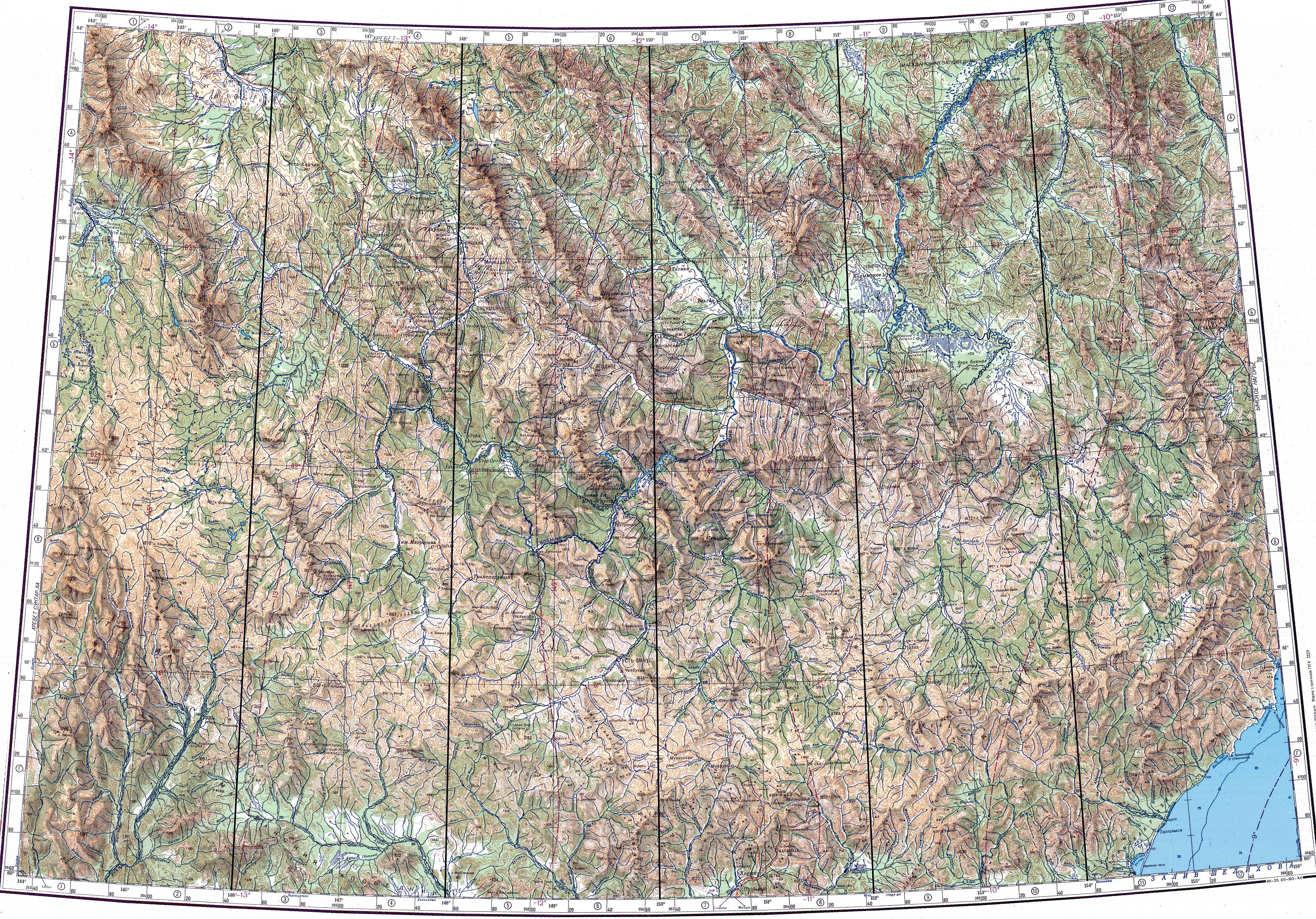
 Слив реке Индигирка | |
| Опште информације | |
| Дужина | 1.726 km |
| Басен | 360.400 km2 |
| Пр. проток | 1 850 m3⁄s |
| Водоток | |
| Извор | планине Калкан |
| В. извора | 790 m |
| Ушће | Северни ледени океан |
| Географске карактеристике | |
| Држава/е | |
| Насеља | Уст-Нера |
| Притоке | Алаиха, Мома |
| ДРВ | 18050000112117700035295 |
| Река на Викимедијиној остави | |
Индигирка (рус. Индигирка) је река у Јакутији у источном делу Русије. Налази се између река Јана[1] и Колима.[2][3] Дуга је 1.726 km, а њен слив покрива 360.000 km². Улива се широком делтом у залив Колима који припада Северном леденом океану. Река Индигирка се замрзава у октобру и остаје под ледом до маја или јуна. Највеће насеље на реци је град Уст-Нера. Дугачка је 1.726 km (1.072 mi). Површина њеног басена је 360.000 km2 (140.000 sq mi).[4]
Историја
Један корисник управо ради на овом чланку. Молимо остале кориснике да му допусте да заврши са радом. Ако имате коментаре и питања у вези са чланком, користите страницу за разговор.
Хвала на стрпљењу. Када радови буду завршени, овај шаблон ће бити уклоњен. Напомене
|
The isolated village of Russkoye Ustye,[5][6][7] located on the delta of the Indigirka, is known for the unique traditional culture of the Russian settlers whose ancestors came there several centuries ago. Some historians have speculated that Russkoye Ustye was settled by Pomors in the early 17th century.[8]
In 1638 explorer Ivan Rebrov reached the Indigirka.[9] In 1636–42 Elisei Buza pioneered the overland route to the Indigirka river system. At about the same time, Poznik Ivanov ascended a tributary of the lower Lena, crossed the Verkhoyansk Range to the upper Yana, and then crossed the Chersky Range to the Indigirka. In 1642 Mikhail Stadukhin reached the Indigirka overland from the Lena.[9]
Zashiversk on the Indigirka was an important colonial outpost during the early days of Russian colonization.[10][11] It was subsequently abandoned in the 19th century. Other historical settlements, now long abandoned, were Podshiversk and Uyandinskoye Zimov'ye.[12][13][14][15]
In 1892–94 Baron Eduard Von Toll carried out geological surveys in the basin of the Indigirka (among other Far-eastern Siberian rivers) on behalf of the Russian Academy of Sciences.[16][17] During one year and two days the expedition covered 25.000 km (16.000 mi), of which 4.200 km (2.600 mi) were up rivers, carrying out geodesic surveys en route.
Курс
It originates at the confluence of the 251 km (156 mi) long Tuora-Yuryakh (also known as Khastakh, Khalkan or Kalkan) river[18] and the 63 km (39 mi) long Taryn-Yuryakh,[19] both of which originate on the slopes of the Khalkan Range.
In its higher course, the river flows northwestwards along the Yana-Oymyakon Highlands, through the lowest part of the Oymyakon Plateau. Turning north, it cuts through several subranges of the Chersky Range. At the point where it crosses the Chemalgin Range the river narrows and flows into a deep gorge, forming rapids. Where it is joined by the Moma river from the southeast, the Indigirka reaches the Momo-Selennyakh Depression, a wide intermontane basin and the middle course of the river begins, where its valley expands. Turning northwards, the Indigirka cuts deeply across the Moma Range and flows northeastwards meandering across the Aby Lowland and widening to 500 m (1.600 ft). After flowing between the neck formed by the eastern end of the Polousny Range and the western end of the Ulakhan-Chistay Range, it flows north with the Kondakov Plateau to the est across the Yana-Indigirka Lowland, part of the greater East Siberian Lowland. Further north, where the terrain becomes completely flat, the Indigirka divides into branches 130 km (81 mi) from the mouth, forming a 5.500 km2 (2.100 sq mi) wide delta. Its waters end up in the Kolyma Bay, East Siberian Sea. Gusinaya Bay is located to the northwest of the mouths of the Indigirka.[20]
The Indigirka freezes up in October and stays under the ice until May–June.
Tributaries
The main tributaries of the Indigirka are, from source to mouth:[4]
- Хастах (Туора-Yuryakh) (лево)[21][22]
- Taryn-Yuryakh (десно)
- Кујдусин (лево)[21][20][23]
- Kyuente (лево)
- Елга (лево)[24]
- Nera (десно)
- Chibagalakh (лево)
- Moma (десно)
- Selennyakh (лево)
- Druzhina (лево)
- Badyarikha (десно)
- Uyandina (лево)
- Shangina (десно)
- Bolshaya Ercha (десно)
- Allaikha (лево)
- Byoryolyokh (лево, into Russko-Ustyinskaya)
- Shandrin (десно, into Kolymskaya)
Луке, насеља и привреда
Main ports on the river are:
There is a gold prospecting industry in the Indigirka basin. Ust-Nera, a gold-mining center, is the largest settlement on the river.
The Indigirka teems with a variety of fishes. Among the most valuable are several whitefish species, such as vendace, chir, muksun, inconnu (nelma), omul, etc.
Ушће
The Indigirka forms a large delta, consisting of a number of streams (each one being labeled on Russian maps as a photo ka (river arm)) and islands. About 100 km (62 mi) before reaching the East Siberian Sea (70° 48′ 45″ С; 148° 54′ 58″ И / 70.8126° С; 148.9162° И), the river splits into two major northeast-flowing streams. The left (westernmost) arm is known as the Russko-Ustyinskaya Protoka; the right arm, the Srednyaya Protoka (Russian for the "Middle Arm"). Further downstream, the third major arm, the Kolymskaya Protoka splits off the Srednyaya Protoka as its right (eastern) distributary, thus justifying the "middle" moniker for the Srednyaya Protoka.[25]
While Srednyaya Protoka means the "Middle Arm", the names of the main western and eastern arms indicate their relative location as well. The Kolymskaya Protoka, or Kolymskoye Ustye is the arm one located on the eastern side, i.e. the "Kolyma side" of the delta (the arm closest to the Kolyma, the eastern neighbor of the Indigirka). The Russko-Ustyinskaya Protoka, apparently known earlier as simply Russkoye Ustye [26] is the arm one located on the western side, i.e. the "Russian side" of the delta (meaning, the side closest to the (European) Russia). These days the name of the Russko-Ustyinskaya Protoka appears as if it were formed from the name of the old Russian village Russkoye Ustye situated there, but originally the opposite is likely to have been the case, the village is named after the river arm (the Russkoye Ustye) on which it was located.
Several flat islands are formed by the channels of the delta. Listed from the east to the west, the major ones are:
- Usun-Ary 71° 23′ 13″ С; 151° 15′ 18″ И / 71.387° С; 151.255° И lies longitudinally along the coast east of the Srednyaya mouth. It is 12 km (7 mi) and 27 km (17 mi) wide.
- Uparovskiy Island 71° 34′ 55″ С; 151° 11′ 46″ И / 71.582° С; 151.196° И lies completely detached 11 km (7 mi) offshore from the Srednyaya mouth. It is about 2 km (1,2 mi) long and 1 km wide.
- Ploskiy Island 71° 28′ 48″ С; 150° 53′ 24″ И / 71.480° С; 150.890° И is the farthest offshore of a cluster of islands at the Srednyaya mouth. It is C-shaped and about 3 km long.
- Bolshoy Fedorovskiy 71° 31′ 59″ С; 150° 30′ 36″ И / 71.533° С; 150.510° И lies between the two mouths of the Indigirka. It is 6 km long and has a maximum width of 4 km.
- Vkodnoy and Oleniy islands lie right at the Prot. Russko Ust'inskaya mouth 71° 32′ 46″ С; 150° 15′ 58″ И / 71.546° С; 150.266° И. Both are of similar size, about 4 km in length.
- Krestovyy Island 71° 26′ 49″ С; 149° 45′ 58″ И / 71.447° С; 149.766° И lies quiet isolated directly to the south of the Lopatka Peninsula, 10 km (6 mi) offshore to the northwest of the main Indigirka mouths. It is 6 km long and 1.6 km wide.
Види још
- Cave lion cubs Boris and Sparta, found on the banks of the Tirekhtyakh tributary[27]
- List of rivers of Russia
- Yana-Oymyakon Highlands§Hydrography
Референце
- ^ Sikora, Martin; Pitulko, Vladimir V.; Sousa, Vitor C.; Allentoft, Morten E.; Vinner, Lasse; Rasmussen, Simon; Margaryan, Ashot; De Barros Damgaard, Peter; de la Fuente Castro, Constanza; Renaud, Gabriel; Yang, Melinda; Fu, Qiaomei; Dupanloup, Isabelle; Giampoudakis, Konstantinos; Bravo Nogues, David; Rahbek, Carsten; Kroonen, Guus; Peyrot, Michäel; McColl, Hugh; Vasilyev, Sergey V.; Veselovskaya, Elizaveta; Gerasimova, Margarita; Pavlova, Elena Y.; Chasnyk, Vyacheslav G.; Nikolskiy, Pavel A.; Grebenyuk, Pavel S.; Fedorchenko, Alexander Yu.; Lebedintsev, Alexander I.; Slobodin, Sergey B.; et al. (2018). „The population history of northeastern Siberia since the Pleistocene”. S2CID 91983065. doi:10.1101/448829. Архивирано из оригинала 1. 5. 2019. г.
- ^ „Kolyma At Kolymskoye”. R-ARCTICNET. Приступљено 2017-08-11.
- ^ „Кулу” [Ayan-Yuryakh]. Вода Россия (на језику: руски). Приступљено 4. 1. 2022.
- ^ а б Река ИНДИГИРКА у Државном регистру вода Русије
- ^ Sakha Republic (Yakutia) Territorial Branch of the Federal State Statistics Service. Численность населения по районам республики на 1 января 2016 года
- ^ Sakha Republic Territorial Branch of the Federal State Statistics Service. Results of the 2010 All-Russian Census. Численность населения по районам, городским и сельским населённым пунктам (Population Counts by Districts, Urban and Rural Inhabited Localities)
- ^ А. И. Гоголев. "История Якутии: обзор исторических событий до начала ХХ в." (A. I. Gogolev. History of Yakutia: Review of Historical Events to the beginning of the 20th century Архивирано мај 27, 2005 на сајту Wayback Machine) Yakutsk, 1999.
- ^ Tatyana Bratkova "Russkoye Ustye". Novy Mir, 1998, no. 4
- ^ а б Lantzeff, George V., and Richard A. Pierce (1973). Eastward to Empire: Exploration and Conquest on the Russian Open Frontier, to 1750. Montreal: McGill-Queen's U.P.
- ^ Grigory Popov (1999). „Missionerstvo v Yakutskom krae (Миссионерство в Якутском крае)” (на језику: руски). Ilin. Приступљено 2009-10-17.
- ^ Maria Starostina (2003). „Srednekolymskaya Pokrovskaya tserkov (Среднеколымская Покровская церковь)” (на језику: руски). Ilin. Приступљено 17. 10. 2009.
- ^ „Momsky natural park” (на језику: руски). Ministry of environment preservation of Sakha Republic. Архивирано из оригинала 2008-09-17. г. Приступљено 2009-10-16.
- ^ Zhargun, Svetlana (20. 11. 2004). „U kazhdogo muzeya svoya sudba (У каждого музея своя судьба)” (на језику: руски). Vostochno-Sibirskaya Pravda. Приступљено 2009-10-16.
- ^ Kennan, pp. 265-266. The original text by Kennan is also reproduced by Harry de Windt in footnote 31 to chapter VII. Authenticity of Kennan's story is uncertain.
- ^ Included in: Else Mendelssohn Benecke (compilation) (2008). Selected Polish Tales. Read Books. стр. 229—232. ISBN 978-1408696316.
- ^ von Toll, Baron E., 1895, Wissenschaftliche Resultate der Von der Kaiserlichen Akademie der Wissenschaften sur Erforschung des Janalandes und der Neusibirischen Inseln in den Jahren 1885 und 1886 Ausgesandten expedition. [Scientific Results of the Imperial Academy of Sciences of the Investigation of Janaland and the New Siberian Islands from the Expeditions Launched in 1885 and 1886] Abtheilung III: Die fossilen Eislager und ihre Beziehungen su den Mammuthleichen. Memoires de L'Academie imperials des Sciences de St. Petersbouro, VII Serie, Tome XLII, No. 13, Commissionnaires de I'Academie Imperiale des sciences, St. Peterabourg, Russia.
- ^ „The Treasure of Eduard Toll - Eduard von Toll”. www.shparo.com. Приступљено 7. 1. 2019.
- ^ Russian State Water Register - Река Хастах (Торо-Юрях, Туора-Юрях, Калкан)
- ^ Russian State Water Register - Река Тарын-Юрях
- ^ а б Google Earth
- ^ а б „P-53_54 Topographic Chart (in Russian)”. Приступљено 22. 5. 2022.
- ^ „P-55_56 Topographic Chart (in Russian)”. Приступљено 22. 5. 2022.
- ^ Water of Russia - Куйдусун
- ^ 1,000,000 scale Operational Navigation Chart; Sheet C-6
- ^ Indigirka in the Great Soviet Encyclopedia.
- ^ Indigirka in Brockhaus and Efron Encyclopedic Dictionary
- ^ Boeskorov, G. G.; Plotnikov, V. V.; Protopopov, A. V.; Baryshnikov, G. F.; Fosse, P.; Dalén, L.; David, S. W. G.; Pavlov, I. S.; Naoki, S.; Alexey, N. T. (2021). „The preliminary analysis of Cave Lion cubs Panthera spelaea (Goldfuss, 1810) from the permafrost of Siberia”. Quaternary. 4 (3): 24. doi:10.3390/quat4030024
 .
.
Спољашње везе
- Indigirka at GEOnet Names Server
- Location of islands
- William Barr, Baron Eduard Von Toll's Last Expedition. Arctic, Sept 1980.
| Државне | |
|---|---|
| Остале | |