
Малави (језеро) — разлика између измена
#1Lib1Ref |
. ознака: везе до вишезначних одредница |
||
| Ред 1: | Ред 1: | ||
{{short description|Велико афричко језеро}} |
|||
{{друго значење3|Lake Malawi (muzička grupa)}} |
{{друго значење3|Lake Malawi (muzička grupa)}} |
||
{{Језеро|центар| |
{{Језеро|центар| |
||
| Ред 6: | Ред 7: | ||
| мапа = |
| мапа = |
||
| опис_м = |
| опис_м = |
||
| површина =29 |
| површина = {{convert|29,600|km2|sqmi|abbr=on}}<ref name=ac/> |
||
| запремина=8400 |
| запремина= {{convert|8400|km3|cumi|abbr=on}}<ref name=ilec/> |
||
| највећа_дубина = |
| највећа_дубина = {{convert|706|m|abbr=on}}<ref name=ilec/> |
||
| просечна_дубина = |
| просечна_дубина = {{convert|292|m|abbr=on}}<ref name=ilec/> |
||
| висина=474 |
| висина=474 |
||
| ширина=75 |
| ширина= {{convert|75|km|abbr=on}}<ref name=ac/> |
||
| дужина=560 |
| дужина= {{convert|560|km|abbr=on}}<ref name=ac/> to 580<ref name=ceonline/> |
||
| elevation = {{convert|468|m|ft}} above sea level<ref name="readersnatural">{{Cite book|title=Natural Wonders of the World|publisher=Reader's Digest Association, Inc|year=1980|isbn=0-89577-087-3|editor-last=Scheffel|editor-first=Richard L.|location=United States of America|pages=222|editor-last2=Wernet|editor-first2=Susan J.}}</ref> |
|||
| врста=природно, тектонско |
| врста=природно, тектонско |
||
| притоке =Рухуху |
| притоке =Рухуху<ref name=ac/> |
||
| отоке = Шира |
| отоке = Шира<ref name=ac/> |
||
| области = |
| области = |
||
| државе={{МВИ}}, {{МОЗ}}, {{ТАН}} |
| државе={{МВИ}}, {{МОЗ}}, {{ТАН}} |
||
| Ред 22: | Ред 24: | ||
| long = 34.366667 |
| long = 34.366667 |
||
}} |
}} |
||
'''Језеро Малави''' или '''језеро Њаса''' је најјужније од [[Велика језера (Африка)|Афричких великих језера]] на [[језерска висораван|језерској висоравни]]. Дуго је 560 до 580 km, има максималну ширину од 75 -{km}- и површину од око 29.600 -{[[квадратни километар|km²]]}-. Треће је по величини језеро Африке и девето у свету. Његова отока је [[Шире]] која се улива у [[Замбези]], а његова највећа притока је [[Рухуху]]. |
'''Језеро Малави''' или '''језеро Њаса''' је најјужније од [[Велика језера (Африка)|Афричких великих језера]] на [[језерска висораван|језерској висоравни]].<ref name=ac>{{Cite web|url= http://www.aquaticcommunity.com/cichlid/malawi.php |title=Malawi Cichlids|access-date=2007-04-02 |work= AC Tropical Fish |publisher=Aquaticcommunity.com}}</ref><ref name=ilec>{{Cite web|url=http://www.ilec.or.jp/database/afr/afr-13.html |title=Lake Malawi |access-date=2007-04-02 |work=World Lakes Database |publisher=International Lake Environment Committee Foundation |url-status=dead |archive-url=https://web.archive.org/web/20070210044454/http://www.ilec.or.jp/database/afr/afr-13.html |archive-date=February 10, 2007 }}</ref> Дуго је 560 до 580 km, има максималну ширину од 75 -{km}- и површину од око 29.600 -{[[квадратни километар|km²]]}-. Треће је по величини језеро Африке и девето у свету. Његова отока је [[Шире]] која се улива у [[Замбези]], а његова највећа притока је [[Рухуху]]. |
||
| ⚫ | |||
| ⚫ | |||
Земље које излазе на њега су [[Малави]], [[Танзанија]] и [[Мозамбик]]. У језеру се налазе два насељена острва, [[Ликома]] и [[Чизумулу]], који припадају Малавију али су окружени територијалним водама Мозамбика. <ref name=unep>{{Cite web|url=http://www.unep-wcmc.org/protected_areas/data/wh/lakemal.html |title=Protected Areas Programme |access-date=2008-06-26 |date=October 1995 |publisher=United Nations Environment Programme, World Conservation Monitoring Centre, UNESCO |archive-url=https://web.archive.org/web/20080511101010/http://www.unep-wcmc.org/protected_areas/data/wh/lakemal.html |archive-date=2008-05-11 |url-status=dead }}</ref> |
Земље које излазе на њега су [[Малави]], [[Танзанија]] и [[Мозамбик]]. У језеру се налазе два насељена острва, [[Ликома]] и [[Чизумулу]], који припадају Малавију али су окружени територијалним водама Мозамбика. <ref name=unep>{{Cite web|url=http://www.unep-wcmc.org/protected_areas/data/wh/lakemal.html |title=Protected Areas Programme |access-date=2008-06-26 |date=October 1995 |publisher=United Nations Environment Programme, World Conservation Monitoring Centre, UNESCO |archive-url=https://web.archive.org/web/20080511101010/http://www.unep-wcmc.org/protected_areas/data/wh/lakemal.html |archive-date=2008-05-11 |url-status=dead }}</ref> |
||
Воде језера Малави су дом за највећи број језерских рибљих врста у свету. Нарочито је познато по [[циклиде|циклидама]]. Национални парк језеро Малави је од [[1984]]. на УНЕСКО листи [[Светска баштина|Светске баштине]]. |
Воде језера Малави су дом за највећи број језерских рибљих врста у свету.<ref name=unep/> Нарочито је познато по [[циклиде|циклидама]].<ref name=Turner2001>Turner, Seehausen, Knight, Allender, and Robinson (2001). "How many species of cichlid fishes are there in African lakes?" ''Molecular Ecology'' 10: 793–806.</ref> Национални парк језеро Малави<ref name=panda>WWF (10 June 2011). [http://wwf.panda.org/?uNewsID=200583 "Mozambique’s Lake Niassa declared reserve and Ramsar site"] Retrieved 17 July 2014.</ref> је од [[1984]]. на УНЕСКО листи [[Светска баштина|Светске баштине]]. Језеро Њаса открио је [[Дејвид Ливингстон]] [[1859]]. године. |
||
== Географија == |
|||
Језеро Њаса открио је [[Дејвид Ливингстон]] [[1859]]. године. |
|||
{{рут}} |
|||
Lake Malawi is between {{convert|560|km|mi}}<ref name=ac/> and {{convert|580|km|mi}} long,<ref name=ceonline/> and about {{convert|75|km|mi}} wide at its widest point. The lake has a total [[List of lakes by area|surface area]] of about {{convert|29,600|km2|sqmi}}.<ref name=ac/> The lake is {{convert|706|m|abbr=on}} at its [[List of lakes by depth|deepest point]], located in a major [[Depression (geology)|depression]] in the north-central part.<ref name=Konings/> Another smaller depression in the far north reaches a depth of {{convert|528|m|ft|abbr=on}}.<ref name=Konings/> The southern half of the lake is shallower; less than {{convert|400|m|ft|abbr=on}} in the south-central part and less than {{convert|200|m|ft|abbr=on}} in the far south.<ref name=Konings/> The lake has shorelines on western [[Mozambique]], eastern [[Malawi]], and southern [[Tanzania]]. The largest river flowing into it is the [[Ruhuhu River]], and there is an outlet at its southern end, the [[Shire River]], a tributary that flows into the very large [[Zambezi River]] in Mozambique.<ref name=ceonline>{{Cite encyclopedia|url= http://www.encyclopedia.com/topic/Lake_Nyasa.aspx#1-1E1:Nyasa-La-full |title=Lake Nyasa |access-date=2011-08-02 |encyclopedia= [[Columbia Encyclopedia|Columbia Encyclopedia Online]]|publisher=[[Columbia University Press]]}}</ref> Evaporation accounts for more than 80% of the water loss from the lake, considerably more than the outflowing Shire River.<ref name=Park2011>Park, L.E.; and A.S. Cohen (2011). Paleoecological response of ostracods to early Late Pleistocene lake-level changes in Lake Malawi, East Africa. Palaeogeography, Palaeoclimatology, Palaeoecology 303: 71–80. {{doi|10.1016/j.palaeo.2010.02.038}}</ref> The outflows from Lake Malawi into the Shire River are vital for the economy as the water resources support hydropower, irrigation and downstream biodiversity.<ref>Bhave, A., Vincent, K. and Mkwambisi, D. (2019) Projecting future water availability in Lake Malawi and the Shire River basin, Future Climate for Africa Brief, Cape Town: CDKN. </ref> Concerns have been raised over the future climate change impacts of Lake Malawi due to the recent decline in lake levels and the overall drying trend.<ref>{{Cite journal|last1=Bhave|first1=Ajay G.|last2=Bulcock|first2=Lauren|last3=Dessai|first3=Suraje|last4=Conway|first4=Declan|last5=Jewitt|first5=Graham|last6=Dougill|first6=Andrew J.|last7=Kolusu|first7=Seshagiri Rao|last8=Mkwambisi|first8=David|date=2020-05-01|title=Lake Malawi's threshold behaviour: A stakeholder-informed model to simulate sensitivity to climate change|url=http://www.sciencedirect.com/science/article/pii/S0022169420301311|journal=Journal of Hydrology|language=en|volume=584|pages=124671|doi=10.1016/j.jhydrol.2020.124671|bibcode=2020JHyd..58424671B|s2cid=213751778|issn=0022-1694}}</ref> The climate in the lake region is already experiencing changes, with the temperatures predicted to increase throughout the country.<ref>Future Climate for Africa, "How can we improve the use of information for a climate-resilient Malawi?", February 2020,https://futureclimateafrica.org/resource/how-can-we-improve-the-use-of-information-for-a-climate-resilient-malawi/</ref> |
|||
The [[Lake Malawi National Park]] is located at the southern end of the lake.<ref>{{cite web|url=https://whc.unesco.org/en/list/289/|title=Lake Malawi National Park|work=World Heritage List|publisher=[[UNESCO]]|access-date=24 October 2015}}</ref> |
|||
<gallery widths="180px"> |
|||
File:Lake Malawi00.jpg|Lake Malawi (1967) |
|||
File:Mwaya Beach, Malawi.jpg|Mwaya Beach |
|||
File:Monoxylon beach Lake Malawi 1557.jpg|Beach at Cape Maclear near Monkey Bay |
|||
</gallery> |
|||
== Геолошка историја == |
|||
[[Датотека:FlankMalawi.png|thumb|left|250п|[[Topographic profile]] of Lake Malawi's [[rift shoulder]]]] |
|||
[[Датотека:Map of Great Rift Valley.svg|thumb|250п|The [[East African Rift]] (red) with the [[Rift Valley lakes]], Malawi being in the south]] |
|||
Malawi is one of the major [[Rift Valley lakes]] and an [[ancient lake]]. The lake lies in a valley formed by the opening of the [[East African Rift]], where the [[African Plate|African tectonic plate]] is being split into two pieces. This is called a divergent plate tectonics boundary. Malawi has typically been estimated to be 1–2 million years old (mya),<ref>{{Cite journal | doi = 10.1371/journal.pone.0001979 | date=Apr 2008 |last1=Wilson |first1=Ab.|last2=Teugels |first2=Gg. |last3=Meyer |first3=A. | title = Marine Incursion: The Freshwater Herring of Lake Tanganyika Are the Product of a Marine Invasion into West Africa| volume = 3| issue = 4| pages = e1979| pmid = 18431469| pmc = 2292254| journal = PLOS ONE| bibcode=2008PLoSO...3.1979W| editor1-last = Moritz| editor1-first = Craig| doi-access=free }}</ref><ref name=Givnish1997>Givnish, T.J.; and K.J. Sytsma, editors (1997). Molecular Evolution and Adaptive Radiation, p. 598. {{ISBN|0-521-57329-7}}.</ref> but more recent evidence points to a considerably older lake with a basin that started to form about 8.6 mya and deep-water condition first appeared 4.5 mya.<ref name=Delvaux1995>Delvaux, D. (1995). Age of Lake Malawi (Nyasa) and water level fluctuations. Mus. roy. Afr. centr., Tervuren (Belg.), Dept. Geol. Min., Rapp. ann. 1993 & 1994: 99–108.</ref><ref name=Sturmbauer2001>Sturmbauer; Baric; Salzburger; Rüber; and Verheyen (2001). Lake Level Fluctuations Synchronize Genetic Divergences of Cichlid Fishes in African Lakes. Mol Biol Evol 18(2): 144–154. {{doi|10.1093/oxfordjournals.molbev.a003788}}</ref> |
|||
The water levels have varied dramatically over time, ranging from almost {{convert|600|m|ft|abbr=on}} below current level<ref name=Cohen2007>Cohen; Stone; Beuning; Park; Reinthal; Dettman; Scholz; Johnson; King; Talbot; Brown; and Ivory (2007). Ecological consequences of early Late Pleistocene megadroughts in tropical Africas. Proc Natl Acad Sci USA 104(42): 16422-16427. {{doi|10.1073/pnas.0703873104}}</ref> to {{convert|10-20|m|ft|abbr=on}} above.<ref name=Delvaux1995/> During periods the lake dried out almost completely, leaving only one or two relatively small, highly [[Hard water|alkaline]] and [[Salt lake|saline]] lakes in what currently are Malawi's deepest parts.<ref name=Delvaux1995/><ref name=Cohen2007/> A water chemistry resembling the current conditions only appeared about 60,000 years ago.<ref name=Cohen2007/> Major low-water periods are estimated to have occurred about 1.6 to 1.0–0.57 million years ago (where it might have dried out completely), 420,000 to 250,000–110,000 years ago,<ref name=Delvaux1995/> about 25,000 years ago and 18,000–10,700 years ago.<ref name=Sturmbauer2001/> During the peak of the low-water period between 1390 and 1860 [[AD]], it may have been {{convert|120-150|m|ft|abbr=on}} below current water levels.<ref name=Givnish1997/> |
|||
== Карактеристике воде == |
|||
The lake's water is alkaline ([[pH]] 7.7–8.6) and warm with a typical surface temperature between {{convert|24|and(-)|29|C|F|abbr=on}}, while deep sections typically are about {{convert|22|C|F|abbr=on}}.<ref name=Staffer2012>Stauffer, J.R.; and H. Madsen (2012). Schistosomiasis in Lake Malawi and the Potential Use of Indigenous Fish for Biological Control. Pp. 119–140 in: Rokni, M.B., editor. Schistosomiasis. {{ISBN|978-953-307-852-6}}.</ref> The [[thermocline]] is located at a depth of {{convert|40-100|m|ft|abbr=on}}.<ref name=Park2011/> The [[oxygen]] limit is at a depth of approximately {{convert|250|m|ft|abbr=on}}, effectively restricting fish and other [[Obligate aerobe|aerobic organisms]] to the upper part.<ref name=Lowe2003>Lowe-McConnell, R.H. (2003). Recent research in the African Great Lakes: Fisheries, biodiversity and cichlid evolution. Freshwater Forum 20(1): 4–64.</ref> The water is very clear for a lake and the visibility can be up to {{convert|20|m|ft|abbr=on}}, but slightly less than half this figure is more common and it is below {{convert|3|m|ft|abbr=on|0}} in muddy bays.<ref name=Konings>[[Ad Konings|Konings, Ad]] (1990). ''Ad Konings' Book of Cichlids and all the other Fishes of Lake Malawi.'' {{ISBN|978-0866225274}}.</ref> However, during the rainy season months of January to March, the waters are more muddy due to muddy river inflows.<ref>{{Cite web|url=https://www.worldatlas.com/articles/what-are-the-primary-inflows-and-outflows-of-lake-malawi.html|title=What Are The Primary Inflows And Outflows Of Lake Malawi?|website=WorldAtlas|language=en|access-date=2019-10-24}}</ref> |
|||
== Европско откриће и колонизација == |
|||
The [[Portuguese people|Portuguese]] trader Candido José da Costa Cardoso was the first [[Europe]]an to visit the lake in 1846.<ref name=Jeal1973>{{cite book|last=Jeal|first =Tim|title=Livingstone|publisher = G. P. Putnam’s Sons|year=1973|location=New York|isbn =9780399112157|url=https://archive.org/details/livingstone00jeal|url-access=registration}}</ref> [[David Livingstone]] reached the lake in 1859, and named it Lake Nyasa.<ref name=ceonline/> He also referred to it by a pair of nicknames: Lake of Stars and Lake of Storms.<ref>{{Cite book|url=https://books.google.com/books?id=t_wsAwAAQBAJ&q=%22lake+of+stars%22+livingstone&pg=PP170|title=David Livingstone, Africa's Greatest Explorer: The Man, the Missionary and the Myth|last=Bayly|first=Paul|date=2014-03-27|publisher=Fonthill Media|language=en}}</ref> The Lake of Stars nickname came after Livingstone observed lights from the lanterns of the fishermen in Malawi on their boats, that resemble, from a distance, stars in the sky.<ref name="EWG">{{cite book|title=Encyclopedia of World Geography|publisher=Infobase Publishing|year=2005|volume=1|page=576|author=R. W. McColl}}</ref> Later, after experiencing the unpredictable and extremely violent gales that sweep through the area, he also referred to it as the Lake of Storms.<ref name="EWG" /> |
|||
== Референце == |
== Референце == |
||
{{reflist}} |
{{reflist}} |
||
== Литература == |
|||
{{Refbegin|30em}} |
|||
* {{Cite journal|last= Mayall|first= James |date=December 1973 |title=The Malawi-Tanzania Boundary Dispute |journal=[[The Journal of Modern African Studies]] |volume=11 |issue=4 |pages=611–628 |doi= 10.1017/S0022278X00008776 |s2cid= 154785268 |url= https://semanticscholar.org/paper/c229d4cd2150c7dff8919fe8c2de9f45bb6e1381 }} |
|||
* [http://www.timesonline.co.uk/tol/news/world/africa/article2617296.ece Recent study on Lake Malawi water levels reveals drought 100,000 years ago] |
|||
* {{cite web |title=Freshwater Fish Species in Lake Malawi (Nyasa) [Southeast Africa] |url=http://fish.mongabay.com/data/ecosystems/Lake%20Malawi.htm |website=[[Mongabay]] |access-date=9 December 2016}} |
|||
* ''Growing up in a Border District and Resolving the Tanzania-Malawi Lake Dispute: Compromise and concessions'', by [[Godfrey Mwakikagile]], African Renaissance Press, 2022 |
|||
* {{citation|title=ISC-GEM Global Instrumental Earthquake Catalogue (1900–2009)|url=http://www.isc.ac.uk/iscgem/index.php|author=ISC|year=2015|publisher=[[International Seismological Centre]]|series=Version 2.0}} |
|||
* {{citation|title=PAGER-CAT Earthquake Catalog|url=https://earthquake.usgs.gov/static/lfs/data/pager/catalogs/|author=USGS|date=4 September 2009|publisher=[[United States Geological Survey]]|series=Version 2008_06.1}} |
|||
* {{cite journal |author1=Harsh K. Gupta |author2=Siyan Malomo |title=The Malawi Earthquake of March 10, 1989: Report of Field Survey |journal=Seismological Research Letters |date=1995 |volume=66 |issue=1 |page=20–27 |doi=10.1785/gssrl.66.1.20 |url=https://pubs.geoscienceworld.org/ssa/srl/article-abstract/66/1/20/141992/The-Malawi-Earthquake-of-March-10-1989-Report-of?redirectedFrom=PDF |publisher=GeoScienceWorld}} |
|||
* {{citation|title=EXPO-CAT Earthquake Catalog |url=https://earthquake.usgs.gov/static/lfs/data/pager/catalogs/ |author=USGS |date=1 December 2008 |publisher=[[United States Geological Survey]] |series=Version 2007-12}} |
|||
* {{cite web |url=https://earthquake.usgs.gov/learn/today/index.php?month=3&day=10&submit=View+Date |title=Today in Earthquake History-March 10 |accessdate=26 June 2008 |work=[[United States Geological Survey]] |date=31 January 2008 }} |
|||
* {{cite journal |last=Jackson|first=James|last2=Blenkinsop|first2=Tom|date=1993|title=The Malawi Earthquake of March 10, 1989: Deep Faulting Within the East African Rift System|url=http://orca.cf.ac.uk/50645/ |journal=Tectonics|volume=12|issue=5|pages=1,131–1,139 |doi=10.1029/93tc01064 |bibcode=1993Tecto..12.1131J}} |
|||
* {{cite journal |last=Gupta|first=Harsh K.|authorlink=Harsh Gupta|last2=Malomo|first2=Siyan|date=1995|title=The Malawi Earthquake of March 10, 1989: Report of Field Survey|url=http://srl.geoscienceworld.org/content/66/1/20 |journal=Seismological Research Letters|volume=66|issue=1|pages=20–27 |doi=10.1785/gssrl.66.1.20}} |
|||
* {{cite book |last=Kalley|first=Jacqueline|last2=Schoeman|first2=Elna|last3=Andor|first3=Lydia Eve|date=1999|title=Southern African Political History: A Chronology of Key Political Events from Independence to Mid-1997|url=https://books.google.com/books?id=oVrVK2ElINMC|publisher=Greenwood|page=190|isbn= 978-0313302473}} |
|||
* {{cite journal |last=Gupta|first=Harsh K.|date=1992|title=The Malawi earthquake of March 10, 1989: a report of the macroseismic survey|journal=Tectonophysics|volume=209|issue=1|pages=165–166 |doi=10.1016/0040-1951(92)90018-2|bibcode=1992Tectp.209..165G}} |
|||
{{Refend}} |
|||
== Спољашње везе == |
== Спољашње везе == |
||
{{Commonscat|Lake Malawi}} |
{{Commonscat|Lake Malawi}} |
||
* [https://earthquake.usgs.gov/earthquakes/eventpage/usp0003sty#general_region M 6.2 - Malawi] – [[United States Geological Survey]] |
|||
{{нормативна контрола}} |
{{нормативна контрола}} |
||
Верзија на датум 8. фебруар 2023. у 09:20
| Малави-Њаса | |
|---|---|
 Језеро Малави | |
| Координате | 12° 11′ 00″ Ј; 34° 22′ 00″ И / 12.183333° Ј; 34.366667° И |
| Тип | природно, тектонско |
| Притоке | Рухуху[1] |
| Отоке | Шира[1] |
| Земље басена | |
| Макс. дужина | 560 km (350 mi)[1] to 580[2] km |
| Макс. ширина | 75 km (47 mi)[1] km |
| Површина | 29,600 km2 (11,429 sq mi)[1] km2 |
| Прос. дубина | 292 m (958 ft)[3] m |
| Макс. дубина | 706 m (2.316 ft)[3] m |
| Запремина | 8.400 km3 (2.000 cu mi)[3] km3 |
| Над. висина | 474 m |
 Малави-Њаса | |
| Водена површина на Викимедијиној остави | |
Језеро Малави или језеро Њаса је најјужније од Афричких великих језера на језерској висоравни.[1][3] Дуго је 560 до 580 km, има максималну ширину од 75 km и површину од око 29.600 km². Треће је по величини језеро Африке и девето у свету. Његова отока је Шире која се улива у Замбези, а његова највећа притока је Рухуху.

Земље које излазе на њега су Малави, Танзанија и Мозамбик. У језеру се налазе два насељена острва, Ликома и Чизумулу, који припадају Малавију али су окружени територијалним водама Мозамбика. [4]
Воде језера Малави су дом за највећи број језерских рибљих врста у свету.[4] Нарочито је познато по циклидама.[5] Национални парк језеро Малави[6] је од 1984. на УНЕСКО листи Светске баштине. Језеро Њаса открио је Дејвид Ливингстон 1859. године.
Географија
Један корисник управо ради на овом чланку. Молимо остале кориснике да му допусте да заврши са радом. Ако имате коментаре и питања у вези са чланком, користите страницу за разговор.
Хвала на стрпљењу. Када радови буду завршени, овај шаблон ће бити уклоњен. Напомене
|
Lake Malawi is between 560 km (350 mi)[1] and 580 km (360 mi) long,[2] and about 75 km (47 mi) wide at its widest point. The lake has a total surface area of about 29,600 km2 (11,429 sq mi).[1] The lake is 706 m (2.316 ft) at its deepest point, located in a major depression in the north-central part.[7] Another smaller depression in the far north reaches a depth of 528 m (1.732 ft).[7] The southern half of the lake is shallower; less than 400 m (1.300 ft) in the south-central part and less than 200 m (660 ft) in the far south.[7] The lake has shorelines on western Mozambique, eastern Malawi, and southern Tanzania. The largest river flowing into it is the Ruhuhu River, and there is an outlet at its southern end, the Shire River, a tributary that flows into the very large Zambezi River in Mozambique.[2] Evaporation accounts for more than 80% of the water loss from the lake, considerably more than the outflowing Shire River.[8] The outflows from Lake Malawi into the Shire River are vital for the economy as the water resources support hydropower, irrigation and downstream biodiversity.[9] Concerns have been raised over the future climate change impacts of Lake Malawi due to the recent decline in lake levels and the overall drying trend.[10] The climate in the lake region is already experiencing changes, with the temperatures predicted to increase throughout the country.[11]
The Lake Malawi National Park is located at the southern end of the lake.[12]
-
 Lake Malawi (1967)
 -
 Mwaya Beach
 -
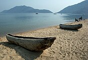 Beach at Cape Maclear near Monkey Bay


Геолошка историја


Malawi is one of the major Rift Valley lakes and an ancient lake. The lake lies in a valley formed by the opening of the East African Rift, where the African tectonic plate is being split into two pieces. This is called a divergent plate tectonics boundary. Malawi has typically been estimated to be 1–2 million years old (mya),[13][14] but more recent evidence points to a considerably older lake with a basin that started to form about 8.6 mya and deep-water condition first appeared 4.5 mya.[15][16]
The water levels have varied dramatically over time, ranging from almost 600 m (2.000 ft) below current level[17] to 10—20 m (33—66 ft) above.[15] During periods the lake dried out almost completely, leaving only one or two relatively small, highly alkaline and saline lakes in what currently are Malawi's deepest parts.[15][17] A water chemistry resembling the current conditions only appeared about 60,000 years ago.[17] Major low-water periods are estimated to have occurred about 1.6 to 1.0–0.57 million years ago (where it might have dried out completely), 420,000 to 250,000–110,000 years ago,[15] about 25,000 years ago and 18,000–10,700 years ago.[16] During the peak of the low-water period between 1390 and 1860 AD, it may have been 120—150 m (390—490 ft) below current water levels.[14]
Карактеристике воде
The lake's water is alkaline (pH 7.7–8.6) and warm with a typical surface temperature between 24 and 29 °C (75—84 °F), while deep sections typically are about 22 °C (72 °F).[18] The thermocline is located at a depth of 40—100 m (130—330 ft).[8] The oxygen limit is at a depth of approximately 250 m (820 ft), effectively restricting fish and other aerobic organisms to the upper part.[19] The water is very clear for a lake and the visibility can be up to 20 m (66 ft), but slightly less than half this figure is more common and it is below 3 m (10 ft) in muddy bays.[7] However, during the rainy season months of January to March, the waters are more muddy due to muddy river inflows.[20]
Европско откриће и колонизација
The Portuguese trader Candido José da Costa Cardoso was the first European to visit the lake in 1846.[21] David Livingstone reached the lake in 1859, and named it Lake Nyasa.[2] He also referred to it by a pair of nicknames: Lake of Stars and Lake of Storms.[22] The Lake of Stars nickname came after Livingstone observed lights from the lanterns of the fishermen in Malawi on their boats, that resemble, from a distance, stars in the sky.[23] Later, after experiencing the unpredictable and extremely violent gales that sweep through the area, he also referred to it as the Lake of Storms.[23]
Референце
- ^ а б в г д ђ е ж „Malawi Cichlids”. AC Tropical Fish. Aquaticcommunity.com. Приступљено 2007-04-02.
- ^ а б в г „Lake Nyasa”. Columbia Encyclopedia Online. Columbia University Press. Приступљено 2011-08-02.
- ^ а б в г „Lake Malawi”. World Lakes Database. International Lake Environment Committee Foundation. Архивирано из оригинала 10. 2. 2007. г. Приступљено 2007-04-02.
- ^ а б „Protected Areas Programme”. United Nations Environment Programme, World Conservation Monitoring Centre, UNESCO. октобар 1995. Архивирано из оригинала 2008-05-11. г. Приступљено 2008-06-26.
- ^ Turner, Seehausen, Knight, Allender, and Robinson (2001). "How many species of cichlid fishes are there in African lakes?" Molecular Ecology 10: 793–806.
- ^ WWF (10 June 2011). "Mozambique’s Lake Niassa declared reserve and Ramsar site" Retrieved 17 July 2014.
- ^ а б в г Konings, Ad (1990). Ad Konings' Book of Cichlids and all the other Fishes of Lake Malawi. ISBN 978-0866225274.
- ^ а б Park, L.E.; and A.S. Cohen (2011). Paleoecological response of ostracods to early Late Pleistocene lake-level changes in Lake Malawi, East Africa. Palaeogeography, Palaeoclimatology, Palaeoecology 303: 71–80. doi:10.1016/j.palaeo.2010.02.038
- ^ Bhave, A., Vincent, K. and Mkwambisi, D. (2019) Projecting future water availability in Lake Malawi and the Shire River basin, Future Climate for Africa Brief, Cape Town: CDKN.
- ^ Bhave, Ajay G.; Bulcock, Lauren; Dessai, Suraje; Conway, Declan; Jewitt, Graham; Dougill, Andrew J.; Kolusu, Seshagiri Rao; Mkwambisi, David (2020-05-01). „Lake Malawi's threshold behaviour: A stakeholder-informed model to simulate sensitivity to climate change”. Journal of Hydrology (на језику: енглески). 584: 124671. Bibcode:2020JHyd..58424671B. ISSN 0022-1694. S2CID 213751778. doi:10.1016/j.jhydrol.2020.124671.
- ^ Future Climate for Africa, "How can we improve the use of information for a climate-resilient Malawi?", February 2020,https://futureclimateafrica.org/resource/how-can-we-improve-the-use-of-information-for-a-climate-resilient-malawi/
- ^ „Lake Malawi National Park”. World Heritage List. UNESCO. Приступљено 24. 10. 2015.
- ^ Wilson, Ab.; Teugels, Gg.; Meyer, A. (април 2008). Moritz, Craig, ур. „Marine Incursion: The Freshwater Herring of Lake Tanganyika Are the Product of a Marine Invasion into West Africa”. PLOS ONE. 3 (4): e1979. Bibcode:2008PLoSO...3.1979W. PMC 2292254
 . PMID 18431469. doi:10.1371/journal.pone.0001979 .
- ^ а б Givnish, T.J.; and K.J. Sytsma, editors (1997). Molecular Evolution and Adaptive Radiation, p. 598. ISBN 0-521-57329-7.
- ^ а б в г Delvaux, D. (1995). Age of Lake Malawi (Nyasa) and water level fluctuations. Mus. roy. Afr. centr., Tervuren (Belg.), Dept. Geol. Min., Rapp. ann. 1993 & 1994: 99–108.
- ^ а б Sturmbauer; Baric; Salzburger; Rüber; and Verheyen (2001). Lake Level Fluctuations Synchronize Genetic Divergences of Cichlid Fishes in African Lakes. Mol Biol Evol 18(2): 144–154. doi:10.1093/oxfordjournals.molbev.a003788
- ^ а б в Cohen; Stone; Beuning; Park; Reinthal; Dettman; Scholz; Johnson; King; Talbot; Brown; and Ivory (2007). Ecological consequences of early Late Pleistocene megadroughts in tropical Africas. Proc Natl Acad Sci USA 104(42): 16422-16427. doi:10.1073/pnas.0703873104
- ^ Stauffer, J.R.; and H. Madsen (2012). Schistosomiasis in Lake Malawi and the Potential Use of Indigenous Fish for Biological Control. Pp. 119–140 in: Rokni, M.B., editor. Schistosomiasis. ISBN 978-953-307-852-6.
- ^ Lowe-McConnell, R.H. (2003). Recent research in the African Great Lakes: Fisheries, biodiversity and cichlid evolution. Freshwater Forum 20(1): 4–64.
- ^ „What Are The Primary Inflows And Outflows Of Lake Malawi?”. WorldAtlas (на језику: енглески). Приступљено 2019-10-24.
- ^ Jeal, Tim (1973). Livingstone
 . New York: G. P. Putnam’s Sons. ISBN 9780399112157.
- ^ Bayly, Paul (2014-03-27). David Livingstone, Africa's Greatest Explorer: The Man, the Missionary and the Myth (на језику: енглески). Fonthill Media.
- ^ а б R. W. McColl (2005). Encyclopedia of World Geography. 1. Infobase Publishing. стр. 576.
Литература
- Mayall, James (децембар 1973). „The Malawi-Tanzania Boundary Dispute”. The Journal of Modern African Studies. 11 (4): 611—628. S2CID 154785268. doi:10.1017/S0022278X00008776.
- Recent study on Lake Malawi water levels reveals drought 100,000 years ago
- „Freshwater Fish Species in Lake Malawi (Nyasa) [Southeast Africa]”. Mongabay. Приступљено 9. 12. 2016.
- Growing up in a Border District and Resolving the Tanzania-Malawi Lake Dispute: Compromise and concessions, by Godfrey Mwakikagile, African Renaissance Press, 2022
- ISC (2015), ISC-GEM Global Instrumental Earthquake Catalogue (1900–2009), Version 2.0, International Seismological Centre
- USGS (4. 9. 2009), PAGER-CAT Earthquake Catalog, Version 2008_06.1, United States Geological Survey
- Harsh K. Gupta; Siyan Malomo (1995). „The Malawi Earthquake of March 10, 1989: Report of Field Survey”. Seismological Research Letters. GeoScienceWorld. 66 (1): 20–27. doi:10.1785/gssrl.66.1.20.
- USGS (1. 12. 2008), EXPO-CAT Earthquake Catalog, Version 2007-12, United States Geological Survey
- „Today in Earthquake History-March 10”. United States Geological Survey. 31. 1. 2008. Приступљено 26. 6. 2008.
- Jackson, James; Blenkinsop, Tom (1993). „The Malawi Earthquake of March 10, 1989: Deep Faulting Within the East African Rift System”. Tectonics. 12 (5): 1,131—1,139. Bibcode:1993Tecto..12.1131J. doi:10.1029/93tc01064.
- Gupta, Harsh K.; Malomo, Siyan (1995). „The Malawi Earthquake of March 10, 1989: Report of Field Survey”. Seismological Research Letters. 66 (1): 20—27. doi:10.1785/gssrl.66.1.20.
- Kalley, Jacqueline; Schoeman, Elna; Andor, Lydia Eve (1999). Southern African Political History: A Chronology of Key Political Events from Independence to Mid-1997. Greenwood. стр. 190. ISBN 978-0313302473.
- Gupta, Harsh K. (1992). „The Malawi earthquake of March 10, 1989: a report of the macroseismic survey”. Tectonophysics. 209 (1): 165—166. Bibcode:1992Tectp.209..165G. doi:10.1016/0040-1951(92)90018-2.
Спољашње везе
| Међународне | |
|---|---|
| Државне | |
| Остале | |