
Канадски штит — разлика између измена
. |
|||
| Ред 2: | Ред 2: | ||
'''Канадски штит''' ({{јез-ен|Canadian Shield}}, {{јез-фр|Bouclier canadien}}) је велика област потковичастог облика који обухвата централну и источну [[Канада|Канаду]] и северне делове [[Сједињене Америчке Државе|САД]]. Заузима површину од око 4,6 милиона квадратних километара што је приближно половина канадске територије. Простире се од [[Северни ледени океан|Арктичког океана]] поред [[Залив Хадсон|Хадсоновог залива]] (заузимајући шест канадских провинција: [[Њуфаундленд и Лабрадор]], [[Квебек]], [[Онтарио]], [[Манитоба]], [[Саскачеван]] и [[Алберта]] те две територије [[Северозападне територије]] и [[Нунавут]]) па све до северних делова америчких држава [[Минесота]], [[Висконсин]], [[Мичиген]] и [[Њујорк (држава)|држави Њујорк]]. |
'''Канадски штит''' ({{јез-ен|Canadian Shield}}, {{јез-фр|Bouclier canadien}}) је велика област потковичастог облика који обухвата централну и источну [[Канада|Канаду]] и северне делове [[Сједињене Америчке Државе|САД]]. Заузима површину од око 4,6 милиона квадратних километара што је приближно половина канадске територије. Простире се од [[Северни ледени океан|Арктичког океана]] поред [[Залив Хадсон|Хадсоновог залива]] (заузимајући шест канадских провинција: [[Њуфаундленд и Лабрадор]], [[Квебек]], [[Онтарио]], [[Манитоба]], [[Саскачеван]] и [[Алберта]] те две територије [[Северозападне територије]] и [[Нунавут]]) па све до северних делова америчких држава [[Минесота]], [[Висконсин]], [[Мичиген]] и [[Њујорк (држава)|држави Њујорк]]. |
||
Канадски штит је формиран пре око 3 милијарде година и добио је име по тврдом [[гнајс]]у и [[гранит]]у који леже испод његове површине и спадају међу најстарије [[стене]] на [[Земља|Земљи]]. Ова област је карактеристична по брдовитим пределима са надморском висином од 300 до 500 метара. [[Планина|Планине]] се налазе на крајњем североистоку Лабрадора и на острву [[Бафинова земља|Бафин]] и уздижу се од 1.700 до 2.100 метара. За време последњег леденог доба пре око 10.000 година, лед који је покривао ову област оголио је танак површински слој земље и формиран је велики број ледничких језера. |
Канадски штит је формиран пре око 3 милијарде година и добио је име по тврдом [[гнајс]]у и [[гранит]]у који леже испод његове површине и спадају међу најстарије [[стене]] на [[Земља|Земљи]].<ref name =EG>{{cite book |last1=Marshak |first1=Stephen |title=Essentials of geology |date=2009 |publisher=W.W. Norton |location=New York |isbn=978-0393932386 |edition=3rd}}</ref> Ова област је карактеристична по брдовитим пределима са надморском висином од 300 до 500 метара. [[Планина|Планине]] се налазе на крајњем североистоку Лабрадора и на острву [[Бафинова земља|Бафин]] и уздижу се од 1.700 до 2.100 метара. За време последњег леденог доба пре око 10.000 година, лед који је покривао ову област оголио је танак површински слој земље и формиран је велики број ледничких језера. |
||
== Географска величина == |
|||
{{рут}} |
|||
The Canadian Shield is a [[Physiographic regions of the world|physiographic division]] comprising four smaller physiographic provinces: the [[Laurentian Upland]], [[Kazan Region]], Davis and James.<ref name=ca-atlas>{{Cite web| author-link =Atlas of Canada |title=Physiographic Regions Map|author=The Atlas of Canada |date=12 September 2016|publisher=Natural Resources Canada |url=https://atlas.gc.ca/phys/en/ |access-date=2019-11-15 }}</ref> The shield extends into the [[United States geology|United States]] as the [[Adirondack Mountains]] (connected by the [[Frontenac Axis]]) and the [[Superior Upland#The Superior Upland|Superior Upland]]. The Canadian Shield is a U-shaped subsection of the Laurentia [[craton]] signifying the area of greatest [[glacial]] impact (scraping down to bare rock) creating the thin soils. The age of the Canadian Shield is estimated to be 4.28 [[Gigaannus|Ga]]. The Canadian Shield once had jagged peaks, higher than any of today's mountains, but millions of years of erosion have changed these mountains to rolling hills.<ref name="Canadian Encyclopedia">{{cite web|last1=James-Abra|first1=Erin|title=Canadian Shield|url=http://www.thecanadianencyclopedia.ca/en/article/shield/|website=Canadian Encyclopedia|access-date=24 January 2018|url-status=live|archive-url=https://web.archive.org/web/20180111135123/http://thecanadianencyclopedia.ca/en/article/shield/|archive-date=11 January 2018}}</ref> |
|||
The Canadian Shield is a collage of [[Archean]] plates and accreted juvenile arc [[terrane]]s and [[sedimentary basin]]s of the [[Proterozoic]] Eon that were progressively amalgamated during the interval 2.45–1.24 Ga, with the most substantial growth period occurring during the [[Trans-Hudson orogeny]], between c. 1.90–1.80 Ga.<ref name=Corrigan>{{cite web |author=Corrigan, D. |year=2008 |title=Metallogeny and Tectonic Evolution of the Trans-Hudson Orogen |url=http://www.pdac.ca/pdac/conv/2008/pdf-tech-session/ts-corrigan.pdf | access-date =2008-03-05 |archive-url = https://web.archive.org/web/20080409105436/http://www.pdac.ca/pdac/conv/2008/pdf-tech-session/ts-corrigan.pdf |archive-date = April 9, 2008}}</ref> |
|||
When the [[Greenland]] section is included, the Canadian Shield is approximately circular, bounded on the northeast by the northeast edge of Greenland, with Hudson Bay in the middle. It covers much of [[Greenland]], all of [[Labrador]] and the [[Great Northern Peninsula]] of [[Newfoundland (island)|Newfoundland]], most of [[Quebec]] north of the [[Saint Lawrence River|St. Lawrence River]], much of [[Ontario]] including northern sections of the [[Ontario Peninsula]], the Adirondack Mountains<ref>Peterson Field Guide to Geology of Eastern North America by Roberts, David & Roger Tory Peterson.</ref> of [[New York (state)|New York]], the northernmost part of Lower [[Michigan]] and all of [[Upper Peninsula of Michigan|Upper Michigan]], northern [[Wisconsin]], northeastern [[Minnesota]], the central and northern portions of [[Manitoba]] away from Hudson Bay, northern [[Saskatchewan]], a small portion of northeastern [[Alberta]],<ref>[http://www.abheritage.ca/abnature/shield/shield.htm Alberta Heritage - Alberta Online Encyclopedia] {{webarchive|url=https://wayback.archive-it.org/2217/20101208161019/http://www.abheritage.ca/abnature/shield/shield.htm |date=2010-12-08 }} - The Canadian Shield Region of Alberta</ref> mainland [[Northwest Territories]] to the east of a line extended north from the Saskatchewan-Alberta border, most of [[Nunavut|Nunavut's]] mainland and, of its [[Arctic Archipelago]], [[Baffin Island]] and significant bands through Somerset, Southampton, Devon and Ellesmere islands.<ref name=britannica>{{Cite encyclopedia|url=https://www.britannica.com/place/Canadian-Shield|encyclopedia=[[Encyclopædia Britannica]] |title=Canadian Shield|access-date=2009-02-10|url-status=live|archive-url=https://web.archive.org/web/20150624232123/https://www.britannica.com/place/Canadian-Shield|archive-date=2015-06-24}}</ref> In total, the exposed area of the Shield covers approximately {{convert|8000000|km2|mi2|abbr=on}}. The true extent of the Shield is greater still and stretches from the [[North American Cordillera|Western Cordillera]] in the west to the [[Appalachian Mountains|Appalachians]] in the east and as far south as [[Texas]], but these regions are overlaid with much younger rocks and sediment.<!---, but by some definitions these submerged regions may not ''technically'' be part of the Shield since they are not on the surfaces. ---> |
|||
{{wide image|Flin Flon Wilderness and Outcrop.jpg|1000px|Panorama of Canadian Shield geography in the [[Flin Flon]], [[Manitoba]], region. Big Island Lake is in the background.}} |
|||
== Геологија == |
|||
The Canadian Shield is among the oldest on Earth, with regions dating from 2.5 to 4.2 billion years.<ref>Tsuyoshi Iizuka, at al., "Geology and Zircon Geochronology of the Acasta Gneiss Complex", ''Precambrian Research'', 153 (2007) pp. 179–208</ref> The multitude of rivers and lakes in the region is classical example of a [[deranged drainage system]], caused by the [[drainage basin|watersheds]] of the area being disturbed by glaciation and the effect of [[post-glacial rebound]].<ref name="physicalgeography.net">{{cite book |last=Pidwirny |first=M. |year=2006 |chapter=The Drainage Basin Concept |chapter-url = http://www.physicalgeography.net/fundamentals/10aa.html |title =Fundamentals of Physical Geography |edition=2nd}}</ref> The Shield was originally an area of very large, very tall [[mountain]]s (about {{convert|12000|m|disp=or||abbr=on}})<ref>{{cite book |last=Clark |
|||
|first=Bruce W. |chapter=Geologic History |pages=[https://archive.org/details/makingconnection00clar/page/95 95] |title=Making Connections: Canada's geography |year=1999 |publisher=Prentice Hall Ginn Canada |location=Scarborough, Ontario |isbn=978-0-13-012635-1 |chapter-url=https://archive.org/details/makingconnection00clar/page/95 }}</ref> with much [[volcanic]] activity, but the area was eroded to nearly its current [[topography|topographic]] appearance of relatively low relief over 500 million years ago.<ref>{{cite journal |last1=Ambrose |first1=J. W. |title=Exhumed paleoplains of the Precambrian Shield of North America |journal=American Journal of Science |date=1 September 1964 |volume=262 |issue=7 |pages=817–857 |doi=10.2475/ajs.262.7.817|bibcode=1964AmJS..262..817A }}</ref><ref>{{cite journal |last1=Shilts |first1=William W. |last2=Aylsworth |first2=Janice M. |last3=Kaszycki |first3=Christine A. |last4=Klassen |first4=Rodney A. |title=Canadian Shield |journal=Geomorphic Systems of North America |date=1987 |pages=119–161 |doi=10.1130/DNAG-CENT-v2.119|isbn=0813753023 }}</ref> Erosion has exposed the roots of the mountains, which take the form of [[greenstone belt]]s in which belts of volcanic rock that have been altered by metamorphism are surrounded by granitic rock. These belts range in age from 3600 to 2680 million years old.<ref>{{cite journal |last1=Card |first1=K.D. |title=A review of the Superior Province of the Canadian Shield, a product of Archean accretion |journal=Precambrian Research |date=August 1990 |volume=48 |issue=1–2 |pages=99–156 |doi=10.1016/0301-9268(90)90059-Y|bibcode=1990PreR...48...99C }}</ref> Much of the granitic rock belongs to the distinctive [[Tonalite-trondhjemite-granodiorite|tonalite–trondhjemite–granodiorite]] family of rocks, which are characteristic of [[Archean]] [[continental crust]].<ref>{{cite journal |last1=Smithies |first1=R.H |title=The Archaean tonalite–trondhjemite–granodiorite (TTG) series is not an analogue of Cenozoic adakite |journal=Earth and Planetary Science Letters |date=15 October 2000 |volume=182 |issue=1 |pages=115–125 |doi=10.1016/S0012-821X(00)00236-3|bibcode=2000E&PSL.182..115S }}</ref> Many of Canada's major ore deposits are associated with greenstone belts.<ref>{{cite journal |last1=de Geoffroy |first1=J. |last2=Wignall |first2=T. K. |title=A probabilistic appraisal of mineral resources in a portion of the Grenville Province of the Canadian shield |journal=Economic Geology |date=1 May 1971 |volume=66 |issue=3 |pages=466–479 |doi=10.2113/gsecongeo.66.3.466}}</ref> |
|||
The [[Sturgeon Lake Caldera]] in [[Kenora District, Ontario]], is one of the world's best preserved [[mineralization (geology)|mineralized]] [[Neoarchean]] [[caldera]] complexes, which is 2.7 billion years old.<ref>[http://www.d.umn.edu/~rmorton/ronshome/Volcanoes/calderas.html Caldera Volcanoes] {{webarchive|url=https://web.archive.org/web/20120814221700/http://www.d.umn.edu/~rmorton/ronshome/Volcanoes/calderas.html |date=2012-08-14 }} Retrieved on 2007-07-20</ref> The Canadian Shield also contains the [[Mackenzie dike swarm]], which is the largest [[dike swarm]] known on [[Earth]].<ref>{{cite journal|doi=10.1190/1.1444345|title=Removing varying directional trends in aeromagnetic data|journal=Geophysics|volume=63|issue=2|pages=446–453|year=1998|last1=Pilkington|first1=Mark|last2=Roest|first2=Walter R.|bibcode=1998Geop...63..446P}}</ref> |
|||
<gallery widths="200px" heights="200px"> |
|||
Image:Temagami greenstone belt pillow lava.jpg|Weathered Precambrian [[pillow lava]] in the [[Temagami Greenstone Belt]] |
|||
File:Nature's Art created by thousands of years of erosion by ice.jpg|Folded Precambrian [[gneiss]] of the Canadian Shield in [[Georgian Bay]], Ontario |
|||
| ⚫ | |||
</gallery> |
|||
== Клима и вегетација == |
== Клима и вегетација == |
||
| Ред 8: | Ред 31: | ||
== Привреда == |
== Привреда == |
||
| ⚫ | |||
Канадски штит има три главна природна ресурса: шуме, руде и воду. Шуме као привредна богатства се највише користе у четири Канадске провинције, Квебек, Онтарио, Манитоба и Саскачеван. Главне руде су бакар, гвожђе, олово, никл, злато, сребро, уранијум и цинк. Крајем 19. века у Северозападним територијама су откривене значајне количине дијаманта. Велики потенцијал река и језера у овој области се користе у производњи струје (хидроцентрале). Канадски штит садржи веома мало обрадивог земљишта. |
Канадски штит има три главна природна ресурса: шуме, руде и воду. Шуме као привредна богатства се највише користе у четири Канадске провинције, Квебек, Онтарио, Манитоба и Саскачеван. Главне руде су бакар, гвожђе, олово, никл, злато, сребро, уранијум и цинк. Крајем 19. века у Северозападним територијама су откривене значајне количине дијаманта. Велики потенцијал река и језера у овој области се користе у производњи струје (хидроцентрале). Канадски штит садржи веома мало обрадивог земљишта. |
||
== Становништво == |
== Становништво == |
||
Област је ретко насељена. Становништво живи углавном у рударским варошима и мањим индустријским центрима. Од већих градови ту су [[Велики Садбери|Садбери]] у Онтарију и [[Шикутими]] у Квебеку са 155.000 становника. |
Област је ретко насељена. Становништво живи углавном у рударским варошима и мањим индустријским центрима. Од већих градови ту су [[Велики Садбери|Садбери]] у Онтарију и [[Шикутими]] у Квебеку са 155.000 становника. |
||
== Референце == |
|||
{{Reflist}} |
|||
== Литература == |
|||
{{Library resources box |by=no |onlinebooks=no |others=yes |about=yes |lcheading=Canadian Shield }} |
|||
{{refbegin|30em}} |
|||
* Schwartzenberger, Tina (2005), ''[https://books.google.com/books?id=f2_0dwVpQGkC&lpg=PP1&dq=Canadian%20Shield&pg=PP1#v=onepage&q&f=true The Canadian Shield]'', Weigl Educational, {{ISBN|1-55388-141-9}} |
|||
* {{cite web|last1 = Percival |first1= J. |last2= Easton |first2= R. |
|||
|url= http://www.geologyontario.mndmf.gov.on.ca/mndmfiles/pub/data/imaging/OFR6196/OFR6196.pdf |title= Geology of the Canadian Shield in Ontario: An Update |work = Ontario Geological Survey |publisher= Geological Survey of Canada |access-date= February 9, 2013}} |
|||
* {{cite web |url=https://www.porcupineprospectors.com/geology/ |access-date=22 June 2019|title=Geology | Porcupine Prospectors and Developers Association}} |
|||
* {{cite web|url=http://www.nicholas.duke.edu/people/faculty/boudreau/9thPtSymposium/Sproule_Abstract.pdf|title=Geochemistry, Petrogenesis, and Metallogenisis of Komatiites in the Abitibi Greenstone Belt, Canada|author1=R. A. Sproule |author2=C. M. Lesher |author3=M. G. Houle |author4=R. R. Keays |author5=J. A. Ayer |author6=P. C. Thurson |access-date=2009-04-11}} |
|||
* {{cite web |url= http://www.mnr.gov.on.ca/en/Business/Biodiversity/2ColumnSubPage/STEL02_166949.html |title= Hudson Bay Lowlands |publisher= Ontario Ministry of Natural Resources |access-date= February 9, 2013}} |
|||
* {{Cite web | title = Middle Proterozoic and The Mid-continent Rift | work = Minnesota's Rocks and Waters | publisher = [[Winona State University]] | url = http://geogroup4.wikispaces.com/file/view/Mid-continentRift.ppt | access-date = 2008-04-13 | archive-url = https://web.archive.org/web/20110718051212/http://geogroup4.wikispaces.com/file/view/Mid-continentRift.ppt | archive-date = 2011-07-18 | url-status = dead }} |
|||
* {{Cite web|url=http://gq.mines.gouv.qc.ca/lexique-stratigraphique/province-de-grenville_en/|title=Grenville Province|date=14 August 2018|website=Géologie Québec|language=fr-FR|access-date=2019-03-28}} |
|||
* {{cite journal|last=Davis| first= Donald W. | date= January 23, 2008| title= Sub-million-year age resolution of Precambrian igneous events by thermal extraction-thermal ionization mass spectrometer Pb dating of zircon: Application to crystallization of the Sudbury impact melt sheet| journal= Geology| volume = 36| number = 5| pages= 383–386 |doi= 10.1130/G24502A.1| bibcode= 2008Geo....36..383D}} |
|||
* {{cite book |title=Geology of the Canadian Shield in Ontario: An Update |url=http://www.geologyontario.mndmf.gov.on.ca/mndmfiles/pub/data/imaging/OFR6196/OFR6196.pdf|isbn=978-1-4249-3434-8}} |
|||
* {{cite book |last1=Phinney |first1=William |title=Science Training History of the Apollo Astronauts |date=2015 |publisher=NASA SP -2015-626 |pages=247, 252}} |
|||
* {{cite encyclopedia |url=http://www.britannica.com/eb/topic-354866/Mackenzie-dike-swarm |title=Mackenzie dike swarm |series=geological feature, Canada |encyclopedia=Britannica Online Encyclopedia}} |
|||
* {{Cite web|url=http://www.thecanadianencyclopedia.com/articles/hudson-bay|title=Canadian Encyclopedia - Hudson Bay}} |
|||
* {{cite web|url=http://www.matawa.on.ca/article/ring-of-fire-news-281.asp|archive-url=https://archive.today/20130629191415/http://www.matawa.on.ca/article/ring-of-fire-news-281.asp|url-status=dead|archive-date=29 June 2013|title=Ring of Fire News: Removing our support, government is not listening|location=Thunder Bay, Ontario|date=21 October 2013|access-date=29 June 2013|publisher=Matawa First Nations}} |
|||
* {{cite web |website=InfoNiagara |url=http://www.infoniagara.com/other/history/geo.html |title=Niagara Falls Geological History |access-date=March 3, 2007 |archive-url=https://web.archive.org/web/20141006094115/http://www.infoniagara.com/other/history/geo.html |archive-date=October 6, 2014 }} |
|||
* {{cite book |isbn=0878421807 |pages=41–55|title=Roadside Geology of New York|last1=Vandiver|first1=Bradford B.|year=1985}} |
|||
* {{cite web | url = http://www.tourniagara.com/geologynature/niagara-escarpment/geological-past/ | title = Geological Past of Niagara Falls and the Niagara Region | access-date = December 21, 2008 }} |
|||
* Irving H. Tesmer, Jerold C. Bastedo, ''Colossal Cataract: The Geologic History of Niagara Falls'' (SUNY Press, 1981, {{ISBN|0-87395-522-6}}) |
|||
* {{cite web |title=Niagara Falls Geology Facts & Figures |url=http://www.niagaraparks.com/media/geology-facts-figures.html |publisher=[[Niagara Parks]] |access-date=April 29, 2011 |url-status=dead |archive-url=https://web.archive.org/web/20110719093559/http://www.niagaraparks.com/media/geology-facts-figures.html |archive-date=July 19, 2011 }} |
|||
* {{cite web | url = http://www.ontla.on.ca/library/repository/mon/29012/333112.pdf| title =Ontario's mineral development strategy 2015| work = Queen's Printer for Ontario 2015 | access-date = 2018-10-19}} |
|||
* {{cite web | url = http://www.ontla.on.ca/library/repository/mon/29012/333112.pdf| title =Ontario's Natural Resources – Minerals and Mining| work = Queen's Printer for Ontario | access-date = 2018-10-19}} |
|||
* {{Cite web|url=https://www.services.gov.on.ca/locations/serviceDetails.do?id=192|title=ServiceOntario - Service Location Finder - Service Details - Apply for a Prospectors licence|date=February 2, 2017|archive-url=https://web.archive.org/web/20170202030319/https://www.services.gov.on.ca/locations/serviceDetails.do?id=192|archive-date=2017-02-02}} |
|||
* {{Cite web|url=https://www.mndm.gov.on.ca/en/mines-and-minerals/mining-act/mining-act-modernization/exploration-permits|title=Exploration Permits | Ministry of Northern Development and Mines|date=September 18, 2017|archive-url=https://web.archive.org/web/20170918155030/https://www.mndm.gov.on.ca/en/mines-and-minerals/mining-act/mining-act-modernization/exploration-permits|archive-date=2017-09-18}} |
|||
{{refend}} |
|||
== Спољашње везе == |
|||
{{Commons category|Canadian Shield}} |
|||
* {{cite web |last1= Baldwin |first1= David |last2= Desloges |first2= Joseph |last3= Band |first3= Lawrence |url= http://www.ubcpress.ca/books/pdf/chapters/ecology/chapter2.pdf |title= Physical Geography of Ontario |access-date= February 9, 2013 |archive-url= https://web.archive.org/web/20071217184751/http://www.ubcpress.ca/books/pdf/chapters/ecology/chapter2.pdf |archive-date= 2007-12-17 |url-status= dead }} |
|||
* {{Cite web|url=https://mern.gouv.qc.ca/english/mines/geology/geology-overview.jsp|title=MERN- Geological Overview|website=mern.gouv.qc.ca|access-date=2019-03-28}} |
|||
{{нормативна контрола}} |
{{нормативна контрола}} |
||
Верзија на датум 11. март 2023. у 15:20

Канадски штит (енгл. Canadian Shield, фр. Bouclier canadien) је велика област потковичастог облика који обухвата централну и источну Канаду и северне делове САД. Заузима површину од око 4,6 милиона квадратних километара што је приближно половина канадске територије. Простире се од Арктичког океана поред Хадсоновог залива (заузимајући шест канадских провинција: Њуфаундленд и Лабрадор, Квебек, Онтарио, Манитоба, Саскачеван и Алберта те две територије Северозападне територије и Нунавут) па све до северних делова америчких држава Минесота, Висконсин, Мичиген и држави Њујорк.
Канадски штит је формиран пре око 3 милијарде година и добио је име по тврдом гнајсу и граниту који леже испод његове површине и спадају међу најстарије стене на Земљи.[1] Ова област је карактеристична по брдовитим пределима са надморском висином од 300 до 500 метара. Планине се налазе на крајњем североистоку Лабрадора и на острву Бафин и уздижу се од 1.700 до 2.100 метара. За време последњег леденог доба пре око 10.000 година, лед који је покривао ову област оголио је танак површински слој земље и формиран је велики број ледничких језера.
Географска величина
Један корисник управо ради на овом чланку. Молимо остале кориснике да му допусте да заврши са радом. Ако имате коментаре и питања у вези са чланком, користите страницу за разговор.
Хвала на стрпљењу. Када радови буду завршени, овај шаблон ће бити уклоњен. Напомене
|
The Canadian Shield is a physiographic division comprising four smaller physiographic provinces: the Laurentian Upland, Kazan Region, Davis and James.[2] The shield extends into the United States as the Adirondack Mountains (connected by the Frontenac Axis) and the Superior Upland. The Canadian Shield is a U-shaped subsection of the Laurentia craton signifying the area of greatest glacial impact (scraping down to bare rock) creating the thin soils. The age of the Canadian Shield is estimated to be 4.28 Ga. The Canadian Shield once had jagged peaks, higher than any of today's mountains, but millions of years of erosion have changed these mountains to rolling hills.[3]
The Canadian Shield is a collage of Archean plates and accreted juvenile arc terranes and sedimentary basins of the Proterozoic Eon that were progressively amalgamated during the interval 2.45–1.24 Ga, with the most substantial growth period occurring during the Trans-Hudson orogeny, between c. 1.90–1.80 Ga.[4]
When the Greenland section is included, the Canadian Shield is approximately circular, bounded on the northeast by the northeast edge of Greenland, with Hudson Bay in the middle. It covers much of Greenland, all of Labrador and the Great Northern Peninsula of Newfoundland, most of Quebec north of the St. Lawrence River, much of Ontario including northern sections of the Ontario Peninsula, the Adirondack Mountains[5] of New York, the northernmost part of Lower Michigan and all of Upper Michigan, northern Wisconsin, northeastern Minnesota, the central and northern portions of Manitoba away from Hudson Bay, northern Saskatchewan, a small portion of northeastern Alberta,[6] mainland Northwest Territories to the east of a line extended north from the Saskatchewan-Alberta border, most of Nunavut's mainland and, of its Arctic Archipelago, Baffin Island and significant bands through Somerset, Southampton, Devon and Ellesmere islands.[7] In total, the exposed area of the Shield covers approximately 8.000.000 km2 (3.100.000 sq mi). The true extent of the Shield is greater still and stretches from the Western Cordillera in the west to the Appalachians in the east and as far south as Texas, but these regions are overlaid with much younger rocks and sediment.

Геологија
The Canadian Shield is among the oldest on Earth, with regions dating from 2.5 to 4.2 billion years.[8] The multitude of rivers and lakes in the region is classical example of a deranged drainage system, caused by the watersheds of the area being disturbed by glaciation and the effect of post-glacial rebound.[9] The Shield was originally an area of very large, very tall mountains (about 12.000 m or 39.000 ft)[10] with much volcanic activity, but the area was eroded to nearly its current topographic appearance of relatively low relief over 500 million years ago.[11][12] Erosion has exposed the roots of the mountains, which take the form of greenstone belts in which belts of volcanic rock that have been altered by metamorphism are surrounded by granitic rock. These belts range in age from 3600 to 2680 million years old.[13] Much of the granitic rock belongs to the distinctive tonalite–trondhjemite–granodiorite family of rocks, which are characteristic of Archean continental crust.[14] Many of Canada's major ore deposits are associated with greenstone belts.[15]
The Sturgeon Lake Caldera in Kenora District, Ontario, is one of the world's best preserved mineralized Neoarchean caldera complexes, which is 2.7 billion years old.[16] The Canadian Shield also contains the Mackenzie dike swarm, which is the largest dike swarm known on Earth.[17]
-
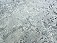 Weathered Precambrian pillow lava in the Temagami Greenstone Belt
 -
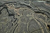 Folded Precambrian gneiss of the Canadian Shield in Georgian Bay, Ontario
 -
 Типичан предео Канадског штита


Клима и вегетација
На овом великом пространству, с обзиром на његов географски положај, преовлађује арктичка и субарктичка клима. На северу је арктичка клима са стално ниским температурама које спречавају раст дрвећа тако да ту углавном преовлађује тундра (степска пространства са ниским травама и маховином). Субарктичка клима преовлађује јужније и има довољно топла лета за раст дрвећа. Ту су се развиле простране четинарске шуме у којима преовлађују црна и бела оморика. Од дрвећа овде још расту бреза, јасика и др.
Привреда
Канадски штит има три главна природна ресурса: шуме, руде и воду. Шуме као привредна богатства се највише користе у четири Канадске провинције, Квебек, Онтарио, Манитоба и Саскачеван. Главне руде су бакар, гвожђе, олово, никл, злато, сребро, уранијум и цинк. Крајем 19. века у Северозападним територијама су откривене значајне количине дијаманта. Велики потенцијал река и језера у овој области се користе у производњи струје (хидроцентрале). Канадски штит садржи веома мало обрадивог земљишта.
Становништво
Област је ретко насељена. Становништво живи углавном у рударским варошима и мањим индустријским центрима. Од већих градови ту су Садбери у Онтарију и Шикутими у Квебеку са 155.000 становника.
Референце
- ^ Marshak, Stephen (2009). Essentials of geology (3rd изд.). New York: W.W. Norton. ISBN 978-0393932386.
- ^ The Atlas of Canada (12. 9. 2016). „Physiographic Regions Map”. Natural Resources Canada. Приступљено 2019-11-15.
- ^ James-Abra, Erin. „Canadian Shield”. Canadian Encyclopedia. Архивирано из оригинала 11. 1. 2018. г. Приступљено 24. 1. 2018.
- ^ Corrigan, D. (2008). „Metallogeny and Tectonic Evolution of the Trans-Hudson Orogen” (PDF). Архивирано из оригинала (PDF) 9. 4. 2008. г. Приступљено 2008-03-05.
- ^ Peterson Field Guide to Geology of Eastern North America by Roberts, David & Roger Tory Peterson.
- ^ Alberta Heritage - Alberta Online Encyclopedia Архивирано 2010-12-08 на сајту Archive-It - The Canadian Shield Region of Alberta
- ^ „Canadian Shield”. Encyclopædia Britannica. Архивирано из оригинала 2015-06-24. г. Приступљено 2009-02-10.
- ^ Tsuyoshi Iizuka, at al., "Geology and Zircon Geochronology of the Acasta Gneiss Complex", Precambrian Research, 153 (2007) pp. 179–208
- ^ Pidwirny, M. (2006). „The Drainage Basin Concept”. Fundamentals of Physical Geography (2nd изд.).
- ^ Clark, Bruce W. (1999). „Geologic History”. Making Connections: Canada's geography. Scarborough, Ontario: Prentice Hall Ginn Canada. стр. 95. ISBN 978-0-13-012635-1.
- ^ Ambrose, J. W. (1. 9. 1964). „Exhumed paleoplains of the Precambrian Shield of North America”. American Journal of Science. 262 (7): 817—857. Bibcode:1964AmJS..262..817A. doi:10.2475/ajs.262.7.817.
- ^ Shilts, William W.; Aylsworth, Janice M.; Kaszycki, Christine A.; Klassen, Rodney A. (1987). „Canadian Shield”. Geomorphic Systems of North America: 119—161. ISBN 0813753023. doi:10.1130/DNAG-CENT-v2.119.
- ^ Card, K.D. (август 1990). „A review of the Superior Province of the Canadian Shield, a product of Archean accretion”. Precambrian Research. 48 (1–2): 99—156. Bibcode:1990PreR...48...99C. doi:10.1016/0301-9268(90)90059-Y.
- ^ Smithies, R.H (15. 10. 2000). „The Archaean tonalite–trondhjemite–granodiorite (TTG) series is not an analogue of Cenozoic adakite”. Earth and Planetary Science Letters. 182 (1): 115—125. Bibcode:2000E&PSL.182..115S. doi:10.1016/S0012-821X(00)00236-3.
- ^ de Geoffroy, J.; Wignall, T. K. (1. 5. 1971). „A probabilistic appraisal of mineral resources in a portion of the Grenville Province of the Canadian shield”. Economic Geology. 66 (3): 466—479. doi:10.2113/gsecongeo.66.3.466.
- ^ Caldera Volcanoes Архивирано 2012-08-14 на сајту Wayback Machine Retrieved on 2007-07-20
- ^ Pilkington, Mark; Roest, Walter R. (1998). „Removing varying directional trends in aeromagnetic data”. Geophysics. 63 (2): 446—453. Bibcode:1998Geop...63..446P. doi:10.1190/1.1444345.
Литература
| Библиотечки ресурси о Канадски штит |
- Schwartzenberger, Tina (2005), The Canadian Shield, Weigl Educational, ISBN 1-55388-141-9
- Percival, J.; Easton, R. „Geology of the Canadian Shield in Ontario: An Update” (PDF). Ontario Geological Survey. Geological Survey of Canada. Приступљено 9. 2. 2013.
- „Geology | Porcupine Prospectors and Developers Association”. Приступљено 22. 6. 2019.
- R. A. Sproule; C. M. Lesher; M. G. Houle; R. R. Keays; J. A. Ayer; P. C. Thurson. „Geochemistry, Petrogenesis, and Metallogenisis of Komatiites in the Abitibi Greenstone Belt, Canada” (PDF). Приступљено 2009-04-11.
- „Hudson Bay Lowlands”. Ontario Ministry of Natural Resources. Приступљено 9. 2. 2013.
- „Middle Proterozoic and The Mid-continent Rift”. Minnesota's Rocks and Waters. Winona State University. Архивирано из оригинала 2011-07-18. г. Приступљено 2008-04-13.
- „Grenville Province”. Géologie Québec (на језику: француски). 14. 8. 2018. Приступљено 2019-03-28.
- Davis, Donald W. (23. 1. 2008). „Sub-million-year age resolution of Precambrian igneous events by thermal extraction-thermal ionization mass spectrometer Pb dating of zircon: Application to crystallization of the Sudbury impact melt sheet”. Geology. 36 (5): 383—386. Bibcode:2008Geo....36..383D. doi:10.1130/G24502A.1.
- Geology of the Canadian Shield in Ontario: An Update (PDF). ISBN 978-1-4249-3434-8.
- Phinney, William (2015). Science Training History of the Apollo Astronauts. NASA SP -2015-626. стр. 247, 252.
- „Mackenzie dike swarm”. Britannica Online Encyclopedia. geological feature, Canada.
- „Canadian Encyclopedia - Hudson Bay”.
- „Ring of Fire News: Removing our support, government is not listening”. Thunder Bay, Ontario: Matawa First Nations. 21. 10. 2013. Архивирано из оригинала 29. 6. 2013. г. Приступљено 29. 6. 2013.
- „Niagara Falls Geological History”. InfoNiagara. Архивирано из оригинала 6. 10. 2014. г. Приступљено 3. 3. 2007.
- Vandiver, Bradford B. (1985). Roadside Geology of New York. стр. 41—55. ISBN 0878421807.
- „Geological Past of Niagara Falls and the Niagara Region”. Приступљено 21. 12. 2008.
- Irving H. Tesmer, Jerold C. Bastedo, Colossal Cataract: The Geologic History of Niagara Falls (SUNY Press, 1981, ISBN 0-87395-522-6)
- „Niagara Falls Geology Facts & Figures”. Niagara Parks. Архивирано из оригинала 19. 7. 2011. г. Приступљено 29. 4. 2011.
- „Ontario's mineral development strategy 2015” (PDF). Queen's Printer for Ontario 2015. Приступљено 2018-10-19.
- „Ontario's Natural Resources – Minerals and Mining” (PDF). Queen's Printer for Ontario. Приступљено 2018-10-19.
- „ServiceOntario - Service Location Finder - Service Details - Apply for a Prospectors licence”. 2. 2. 2017. Архивирано из оригинала 2017-02-02. г.
- „Exploration Permits | Ministry of Northern Development and Mines”. 18. 9. 2017. Архивирано из оригинала 2017-09-18. г.
Спољашње везе
- Baldwin, David; Desloges, Joseph; Band, Lawrence. „Physical Geography of Ontario” (PDF). Архивирано из оригинала (PDF) 2007-12-17. г. Приступљено 9. 2. 2013.
- „MERN- Geological Overview”. mern.gouv.qc.ca. Приступљено 2019-03-28.
| Међународне | |
|---|---|
| Државне | |
| Остале | |